
SUMMER'S LAST BREATH?
Summer isn't done with us just yet and that will be pretty evident on Monday. A warm front will be lifting north of the area and lead to a warm, muggy day... For the last day of September temperatures will be running 10-20 degrees above normal across the Upper Midwest. Coupled with high humidity it will likely feel like the low 90s in the afternoon. A cold front will then begin to slowly move through Monday night through Wednesday and will lead to multiple rounds of showers a

WHO TURNED THE FAUCET ON?
As Terry said in his last post, it has been soggy around here lately. Some of us needed rain and then got too much too soon. An example is what happened Friday night. Check out these rainfall totals - From nearly nothing in Cedar Rapids to 4-8" in portions of Illinois! The heavy rain is attributed to storms training (or moving over the same area repeatedly) and a tropical airmass in place. Here's a look at the precipitable water values on Saturday evening - Precipitable water

EXCESSIVE RAINS POUND PARTS OF THE MIDWEST...WE'RE NOT DONE YET!
The past 30 days have featured a wetter than normal weather pattern across the Pacific Northwest, Northern Rockies/Plains, & Midwest. The precipitation footprints from Dorian, Imelda, & remnants of Lorena are also visible. Many southeastern regions were abnormally to historically dry. The 30 day departures Attached is September's precipitation-to-date rankings through the 25th. Green Bay, & Salem, OR witnessed their wettest Sept 1-25 on record. Conversely, it's the first time

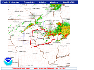
TORNADO AND T/STORM WATCHES ISSUED...
The Storm Prediction Center has issued thunderstorm and tornado watches for areas near and south of HWY 20. Scattered storms have begun to form in my western counties and they are likely to intensify as they move southeast into a more unstable environment. Here are the specifics of the watches. . TORNADO WATCH UNTIL 11:00 PM: SEVERE THUNDERSTORM WATCH UNTIL 11:00 PM Along with the threat of severe weather, the strongest storms are likely to produce very heavy rain on the orde

STRONG STORMS THREATEN THE SOUTH LATER TODAY...
A complex set-up exists late this afternoon and evening for strong to severe thunderstorms in my southern counties, especially south of I-80 in SE Iowa and WC Illinois. The potential is complicated by the lack of robust heating but shear profiles and convergence are there for a few supercells towards evening. Low level hodographs are also enlarged and with any supercells that develop there is a risk of a tornado. Some of the hi-resolution short term convective models are show