


SHADES OF 2008, HOPEFULLY NOTHING MORE...

For those who do not remember 2008, it was a remarkable year for flooding over the eastern half of Iowa. Between May 10-June 10th 15-20″ of rain fell on the cedar River watershed. The result was catastrophic flood in Cedar Rapids where the the Cedar crested more than 12 feet above flood stage. Nearly 4,000 homes were flooded and damage of 1.5 billion dollars was measured. 9 major Iowa rivers crested at all time highs. Here is a summary of some of the flood facts.
Quick Summary for the 2008 Midwest Flood: *Two dozen people killed and 148 injured *Approximately 35,000 – 40,000 people evacuated from homes *Flood warnings cover a span of about 325 miles from Dubuque, Iowa to St. Louis, Missouri *Mississippi crested at 37 feet in St. Louis area, seven feet above flood level *Iowa’s agricultural economic losses are estimated to exceed $2 billion *9 Iowa rivers crested at record levels *83 of 99 Iowa counties are disaster areas *21 Illinois counties declared disaster areas *Cedar Rapids – water covered 1,300 city blocks, 9.2 square mile *Cedar Rapids – City Hall, the Linn County jail, the fire department, police communication equipment, most of the public library’s collection and 3,900 homes were all under water *Cedar River flood crest exceeds historic 1929 record *Cedar River flood crested at over 32 feet Friday, June 13 *South Dakota, Minnesota, Wisconsin, Nebraska, Illinois and Indiana have also been affected *Floods have wrecked the Midwest’s corn and soybean crops *22 levees breeched as of 6.20.08 *Abnormally heavy snowpack with unseasonably heavy rainfall are root causes of flooding*Cedar Rapids recorded 24.09 inches of rain for the year – more than 10 inches above normal*Other parts of Eastern Iowa within the Cedar watershed recorded from 15–20 inches of rain between May 10–June 10.*Cedar River has flooded more than 4,000 homes and many businesses in Cedar Rapids*Areas of Cedar Rapids are flooded beyond the so-called 500-year flood level of 26.5 feet*Damage costs in Cedar Rapids estimated at over $1.5 Billion

Meteorological Factors Leading up to the Flood of 2008 from the NWS Quad Cities
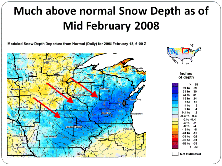
The culmination of many above normal to record meteorological factors, from the winter of 2007-2008 through the spring of 2008, led to the historic Midwest Flood of June 2008. Locally this flood might be most remembered for its devastating impacts in the Cedar Rapids, Iowa City, Oakville, and Gulfport areas.
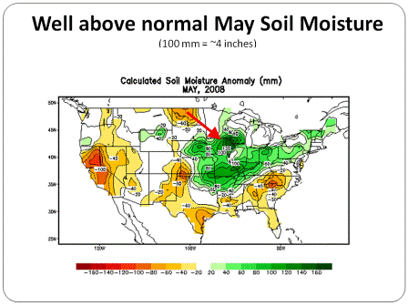
Key Contributing factors to the Historic Flooding of 2008:
Heavy winter snow (from late 2007 through early 2008)
* Significant flooding in April 2008 (resulting in high river levels)
* Extremely moist soils (continuing through May)
* Heavy June rains
= Historic flooding


The big difference this year 2014, is that going into spring river and soil moisture levels were much lower than 2008. Additionally, the rains which have been just as excessive if not heavier this year, have been centered slightly further north and west. So far, that’s made all the difference. Even so as you can see below, many eastern Iowa rivers are experiencing flooding with moderate to major levels anticipated in several reporting stages.

CLICK FOR RIVER STAGES
With another significant rain threat due in over the weekend and into early next week, this is far from over. Here is the rainfall forecast on tonight’s GFS over the next 7 days. 3-5″ is shown over much of Iowa, SE Minnesota, and SW Wisconsin.

It’s very difficult to say how this plays out. I’m not suggesting this is anywhere close to 2008 levels but I am concerned. Models have a hard time forecasting rainfall from large convective systems where training is involved. In fact, they often times underestimate rain totals in a situation such as the one coming up. I hope I’m wrong but it would not shock me to see some localized places in the upper Midwest pick up 6-8″ of rain between Friday and next Tuesday. I have no idea where that will be other than the focus looks along and north of I-80.
Anybody with river interests from Minneapolis to the Quad Cities…including the Mississippi River should pay close attention to forecast trends in the days ahead. I’ll keep monitoring the situation while hoping it does not escalate to 2008 levels. More to come. In the meantime….roll weather! TS


