


SPRING IS OFFICIALLY ON "SPRING BREAK"...
Some folks in parts of eastern Iowa and SW Wisconsin got to enjoy some late season snow early Thursday. While amounts from EC Iowa into WC Wisconsin were generally an inch or less it's somewhat rare to see snow this late in the year. This image was sent my way by Chad Hesket of Anamosa, Iowa showing enough of the white gold to write hi on the car wind shield!

Here's the general area where snow was reported.

For most of the event rain was the dominate form of precipitation. Here you can see where the system produced the greatest amounts.

Back to the topic of snow, a remarkable event hit the central Midwest May 1-3 in 2013. Here's a nice account of the record breaking storm from the NWS in Des Moines.
May 1-3, 2013 Historic Spring Snowstorm
An unprecedented spring snowstorm impacted the central United States from May 1 to May 3, dropping record-shattering amounts of snow up and down the western Mississippi River Valley. Some locations across the southern United States saw their first ever May snowfall and cities in Kansas and Missouri saw their highest snowfall totals in 106 years. Meanwhile, noteworthy May single day and storm total records for the states of Iowa, Minnesota, and Wisconsin were eclipsed by this event. South central Iowa up through southeast Minnesota and western Wisconsin bore the brunt of the snowfall with 10+ inch reports not uncommon. Warm road temperatures across Iowa helped to initially melt the falling snow, but conditions quickly deteriorated across the regions where heavier snow fell. This led to numerous accidents and spin outs. Sporadic power outages also occurred as snow-coated tree branches broke and took out power lines.
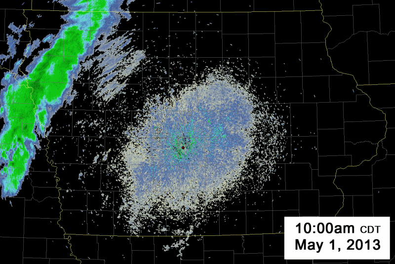
Radar loop of the snowstorm from the Des Moines WSR-88D Radar from 10am on May 1 to 6pm on May 3 (56 Hours!)

Snowfall totals map from May 1 to 3 across Iowa. The highest snowfall amounts were recorded in south central and north central Iowa.

Snowfall totals across the central United States from the storm.
Records Broken
May snowfall and temperature records across Iowa fell like dominoes during this historic event. Below is a listing of central Iowa and statewide records that were surpassed. Previous records are listed in italics.
State of Iowa
- Highest May Storm Total Snowfall: 13.0" in Osage (10.0" in Le Mars on 5/28/1947) - Biggest Iowa Snowstorm based on Average Statewide Snowfall: 3.3" ** (1.2" on 5/28/1947) - Latest Spring Storm to produce more than a Foot of Snowfall: 5/1/2013 to 5/3/2013 (4/20/1918 and 4/20/1992)
Des Moines
Snowfall - 5/2 Daily Snowfall Record: 3.4" (T in 1976) - 5/3 Daily Snowfall Record: 3.5" (1.2" in 1907) - Monthly (May) Maximum One Day Snowfall: 3.5" on 5/3/2013 (1.2" set on 5/3/1907) - Total May Snowfall: 6.9" (1.3" in 1907) - Latest Snowfall of 3.5": 5/3/2013 (4/29/1907) Interesting Fact: Snow was continuously reported at the Des Moines Airport from 6:34am on May 2 to 2:48pm on May 3, or for an uninterrupted 31 hours and 14 minutes! Temperature - 5/2 Record Low Maximum Temperature: 41 (47 in 1953) - 5/3 Record Low Maximum Temperature: 35 (41 in 1967) - Monthly (May) Record Low Maximum Temperature: 35 on 5/3/2013 (39 on 5/5/1944) Interesting Fact: The average temperature at Des Moines on May 3 was 34.5 degrees, tying it with May 5, 1944 for the coldest May day on record. That day in 1944 was also the last time Des Moines had measurable snowfall in May (0.2").
Waterloo
Snowfall - 5/2 Daily Snowfall Record: 1.2" (T in 2005/1976) - 5/3 Daily Snowfall Record: 0.5" (Ties Previous Record of 0.5" in 1935) - Second Highest Total May Snowfall: 1.7" (Highest Total: 2.0" in 1945 and 1947) Temperature - 5/2 Record Low Maximum Temperature: 39 (42 in 1909) - 5/3 Record Low Maximum Temperature: 36 (38 in 1954) - Monthly (May) Record Low Maximum Temperature: 36 on 5/3/2013 (37 on 5/1/1909)
Mason City
Snowfall - 5/2 Daily Snowfall Record: 6.0" (T in 1954) - 5/3 Daily Snowfall Record: 3.5" (T in 1954) - Monthly (May) Maximum One Day Snowfall: 6.0" on 5/2/2013 (4.0" set on 5/28/1947 and 5/8/1938) - Total May Snowfall: 9.5" (4.5" in 1947) - Latest Snowfall of 6.0": 5/2/2013 (4/14/1949) Temperature - 5/2 Record Low Maximum Temperature: 36 (40 in 1935) - 5/3 Record Low Maximum Temperature: 33 (35 in 1954) - Monthly (May) Record Low Maximum Temperature: 33 on 5/3/2013 (34 on 5/1/1909)
Meteorological Overview
It took a combination of several unseasonably strong and unusual features to produce this exceeding rare snow event.
The last few days of April were characterized by warm, summer-like temperatures with Des Moines reaching 86 degrees on the 30th. This was a welcome reprieve after what had been undoubtedly a cold and damp start to spring. This warmup came to an abrupt end late on Tuesday, April 30 as a strong cold front slid through Iowa, igniting several severe thunderstorms over the southwest corner of the state. Temperatures behind the front began falling on Tuesday night and kept dropping through the day on Wednesday (May 1), with many locations recording their warmest readings for the day shortly after midnight. Daytime temperatures on May 1 were a full 30-40 degrees colder than the previous day. The surface observation map animation on the left loops between the early morning hours of May 1 and May 2, showing the stark change in temperatures (in red) over the state after the passage of the front.
Just behind the surface cold front, a strong mid to upper level trough of low pressure slid southeastward from Canada. However, a large stationary ridge of high pressure, known as a omega block, was also taking shape across the eastern United States. Its forward progress inhibited, the upper level trough simply came to a grinding halt over Iowa. The trough eventually formed a cut-off low centered over the south central US by Friday morning (May 3), which meandered over the region for the next three days before drifting eastward. The system was also able to tap into a nearly continuous supply of moisture from both the Gulf of Mexico and western Atlantic Ocean during its stay over the Midwest. This moisture worked up into Iowa, where strong mesoscale and synoptic lift generated a wide swath of precipitation that fell for days straight. The synoptic setup for this event is shown in the image on the right.
The precipitation shield first took the shape of rain showers over southeast South Dakota and northwest Iowa late on April 30th. This band of rain lifted northwestward during the overnight hours as the trough stalled and began transitioning to snow over far northwest Iowa just before sunrise on Wednesday, May 1. It then began a slow, steady march to the southeast over the next 36 hours. The leading edge of the precipitation shield consisted of light rain with embedded heavier showers. The rain eventually transitioned to a rain/snow mix and eventually snow as continued cold air advection and melting ice crystals cooled temperatures aloft below freezing. The cross section on the left attempts to tie the type and location of forcing, vertical temperature/moisture profiles, and radar signatures to what was observed on the ground. The diagram shows that the precipitation-generating frontogenetical forcing on the eastern side of the precipitation shield was well within the low-level above freezing layer, leading to the rain (and lack of a melting layer aloft in CC). Meanwhile as one travels further NW the frontogenesis band becomes more elevated and broad, synoptic lift associated with the trough of low pressure becomes evident in the omega plot. This leads to the generation of large snowflakes aloft (note how the omega maximum is located in the dendritic growth zone) that, as they fall/melt through the 850-700mb warm layer, quickly cause the air to cool below freezing and allow the snow to reach the ground. This schematic almost perfectly matches what was seen in the CC radar product (top right), where the melting layer shows up as the area of orange and yellow values.
The cold air advection and cooling due to melting snow caused the rain/snow line to shift all the way to east central Iowa. The line then became stationary late on May 2 as the upper level trough transitioned to a closed low. The rain/snow line then retreated back to the west during the day on May 3 as a broad region of warm air wrapped north and west around the eastern flank of the low. This surge of warm air eventually brought the snow to an end by late in the day on Friday, but a widespread, cold rainfall continued into the weekend with the cut-off low spinning overhead.
Below is a picture taken in Dakota City, Iowa of a car buried in snow May 3rd, 2013

Thanks to the NWS for the recap............................................................................................................
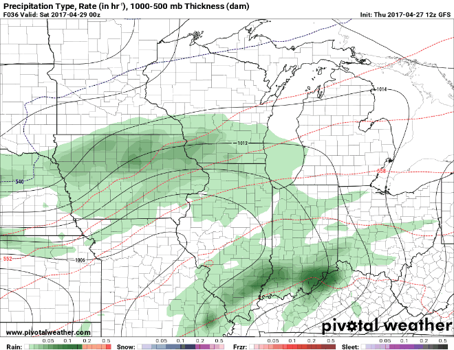
This year another big storm is getting set to hit the Midwest only this time the snow will be further northwest than in 2013. Here's where the GFS shows the heaviest snow falling this coming Sunday night and Monday.

This will be caused by a deep low pressure which will track from Texas into Iowa Saturday through Monday. Here's the low causing widespread precipitation Monday. The blue depicts the snow.

In this animation you can watch the evolution of the system as it grinds across the Midwest.
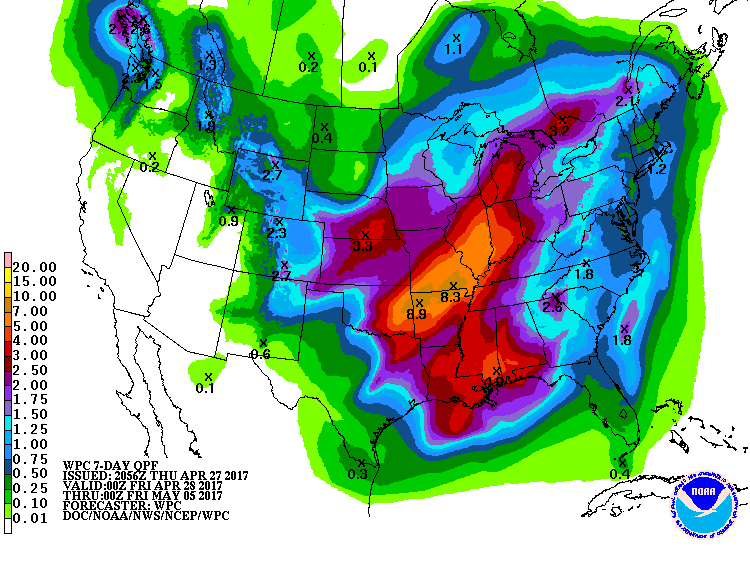
With the Gulf of Mexico wide open moisture will not be an issue and widespread rains of 1-3" will occur over much of the Midwest. Even heavier amounts are expected in parts of Missouri and Illinois where flooding is a significant risk. Here's what the Weather Prediction Center is showing for rain over the next week.
By the way, this chilly pattern is not expected to break anytime soon. Here's what the CVSv2 has for temperature departures the next 10 days.

That's unacceptable! Spring is officially on spring break until further notice. Roll weather...TS


