


FLIP FLOP, SNOW COULD DROP....
- Feb 20, 2018
- 2 min read
Whoa Nellie, Monday was a crazy day for temperatures around my area and the Midwest as a whole. Just in the state of Iowa alone, highs ranged from the upper teens in the northwest to 66 in Ottumwa. Two seasons in one small state.
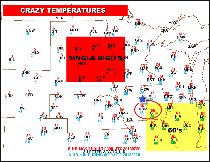
Even more impressive in Iowa was the range from Des Moines to Ottumwa where the spread was 30 degrees in roughly 80 miles. Nice! Oh by the way, virtually impossible to predict.

Now we're heading into a big change as we transition from a trough in the west ridge in the east pattern to the opposite set-up with a ridge west and trough east. It will take at least 10 days to kick in but blocking in Canada and an undercutting jet should make for a colder and potentially stormy period in the Midwest as we enter March. With this flip flop snow could drop. Take a look at the difference in the 500mb jet stream flow.
Today:

March 5th...a complete reversal.

You can also see the difference in the temperature departures. Today, above normal over the entire eastern U.S.

March 5th, well below normal temperatures over the eastern U.S.

This turn to colder weather is well supported by teleconnections. Note the AO (Arctic Oscillation) NAO (North Atlantic Oscillation) and EPO all going strongly negative by March 1st.


Get a load of the temperature departures associated with each of those teleconnections in March. Can you say chilly?
The AO:

The NAO:

The EPO:

All three of the teleconnections support widespread colder than normal temperatures. The unanswered question is will it be just a little colder or a whole bunch. Throw in the MJO which is headed for cold March phases of 1, 2, and 3 and the evidence is very strong for a wintry March.

In fact, I think the potential is on the table for some very significant late winter snowfall, especially over the upper Midwest with an emphasis on the NW half of Iowa, Minnesota, and much of Wisconsin. Some of that could work further south but that's the area I would bet on. The EURO weeklies just in support that idea. Here's the 46 day snowfall off the control.

The 46 mean looks like this.

Even the pattern during the overall transition looks active. After today's storm kicks east the next one to watch comes this weekend. There's pretty good agreement on a dynamic system but models are really spread on the storm tracks and who gets the snow. The GFS has been the most erratic and I won't even put it up until I can see some sort of consistent pattern or match to the EURO. Maybe tomorrow.
OK, that's enough for today. For those of you who got the warmth Monday I hope you enjoyed it The future looks interesting. Roll weather...TS


Comments