


WINTER STORM THIS WEEKEND...
- Mar 22, 2018
- 2 min read
Confidence is growing that some part of my area will see a significant late season snow event this weekend. There's still details to unearth but this much we do know.
High confidence: A winter storm will occur in parts of Iowa, Minnesota, Wisconsin, and Illinois.
High confidence: Strong winds of 30-35 mph will accompany the storm.
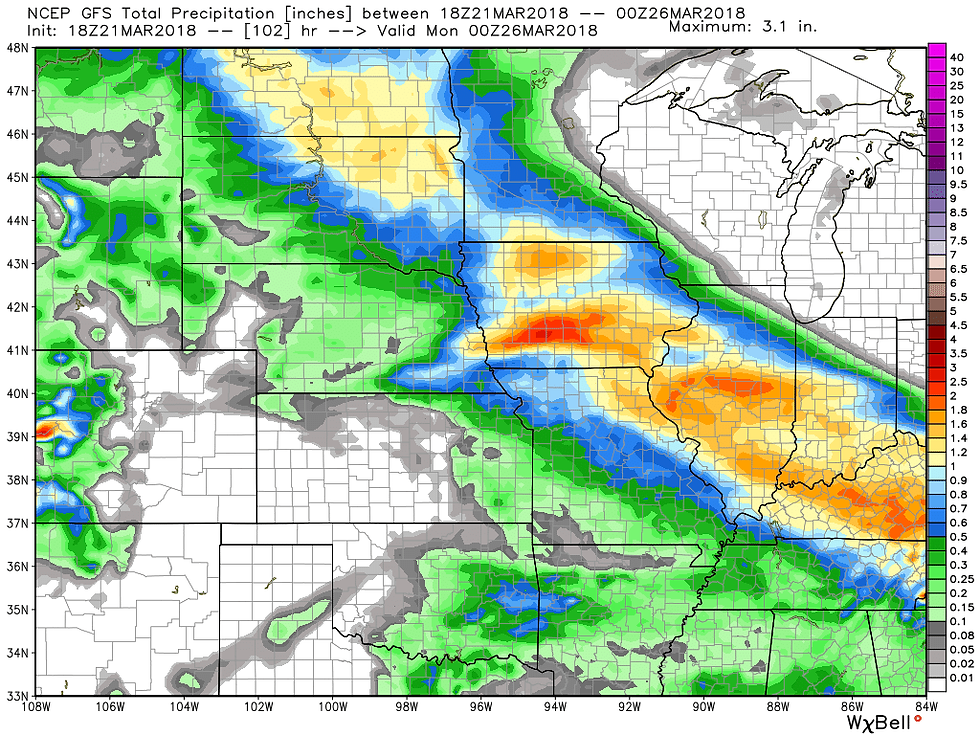
High confidence: Heavy precipitation totals of 1.00 to 1.50 will occur in my area.
High confidence: Timing for Friday night and Saturday
Medium confidence: Placement of the heaviest snow band.
Low to medium confidence: Amount of snowfall in any location
As of Wednesday night there is good agreement in modeling that a surface low accompanied by a tight pressure gradient will develop Friday in Kansas. From there it enters Missouri Friday night reaching peak intensity. After that it turns southeast Saturday on a track through St. Louis. Saturday morning at 6:00am the GFS and EURO show these surface depictions. Good consistency in placement and intensity.


As mentioned this system will have a significant moisture fetch and heavy precipitation is a given in many areas. This is what the GFS and EURO show for total precipitation. It starts Friday night and continues Saturday.

Winds will be a factor. By Saturday morning the EURO shows E winds gusting 35-40 mph over much of the central Midwest.

As is often the case in late March, forecasting snow is often a headache. Low level temperatures are marginal and a process known as dynamic cooling will come into play when determining the snow band. It appears there will be a sharp cut-off to the accumulating snows on both the northern and southern flank of the snow shield. In between, a relatively narrow but intense band of heavy snow is is expected.
It's too early to define the final track and amounts of snow, especially with the timing of the transition from rain to snow tied to dynamic cooling. However, models are converging on a solution and confidence is growing that the northeast 2/3rds of my area will get in on the larger totals, I do expect winter storm watches to be issued at some time Thursday.
Here's what some of the models are showing for snow accumulations. Don't get caught up in the number or the exact placement. There will be revisions but we are within 48 hours of the event and modeling is getting tighter. Take a peak.
Here's the 0z NAM

The 0z GFS

The 3k NAM shows this. However, it's only out until 1:00am and there is still more than 12 hours of snow to come. Keep than in mind.

Last but not least, the EURO, The model has been very consistent for 36 hours and certainly has some impressive snow totals. If this verifies most of my area will have some big issues to deal with by Saturday morning!

The data gets richer tomorrow and we should be able to tighten things up and get the watches issued and the focus narrowed. More later. Until then, roll weather...


Comments