


A BIG TICKET STORM IS ON THE WAY
What you're looking at is a GOES 16 hi-res satellite image. It shows an advancing trough off the west coast of the country. The energy is on its way to becoming a powerful mid-latitude cyclone that will impact the Midwest this weekend.

Friday evening a deep low pressure is centered over SW Iowa. Precipitation runs from Maine to Utah and Lake Superior to the Gulf of Mexico.

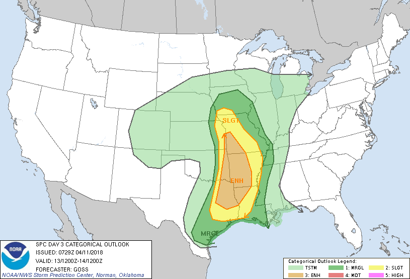
Strong thunderstorms are expected from SW Iowa into Texas and Arkansas. As of Wednesday evening the Storm Prediction Center shows the area where the most active convection is expected to be focused.
The system is drawing vast amounts of moisture northward with PWAT's (precipitable water values) of more than and inch all the way to Green Bay.

With moisture comes high dew points and they are forecast to reach the low 60s all the way to CENTRAL Iowa. Easily the most humid air mass we have seen this year.

The warm sector of the storm will produce highs in the 70s Friday afternoon. I still have my doubts the warmth will be this far north but that's what most models are currently showing. I'm concerned about a bust here.

With the warmth and moisture will come instability. CAPE (convective available potential energy) will be sufficient for thunderstorms. Some as mentioned could be strong, especially from SW Iowa into NE Kansas and NW MIssouri.

The size of the storm is reflected in the large amount of heavy precipitation shown on all the models. There's one axis north of the low and warm front over the upper Midwest. Another extends from the Ohio Valley back to Louisiana in the warm sector ahead of the cold front.

Despite the fact we'll be into mid-April there's also a wintry side to the storm. Look at the winter storm watches in effect.

Here's some of the snow totals the EURO is showing. It's very early so these amounts will change but it gives you a good idea this is big ticket winter storm for the upper Midwest.

The GFS shows this for snowfall.

This is an extremely complex and dynamic system that will impact the Midwest in some way shape or form Friday through Monday of next week. Lots of challenges and a difficult forecast ahead. Roll weather...TS


