IT'S HERE, TAKE IT IN....
- terryswails1
- Jul 26, 2018
- 2 min read
It seems as though I've been talking about it for forever (in reality 3 weeks) but the fall preview I've been advertising is underway. This weekend I'm projecting highs in the low to mid 70s which will make this the coldest 3 day period (Friday-Sunday) since May 11-13th when the weekend average was 60.3.

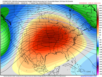
You can see the cool air arriving on the 500mb jet which is buckling into this position Friday.

Come Wednesday a full-latitude trough is covering the central U.S. You don't see an upper air pattern like that very often in late July.

It very clearly coincides with the Euro MJO cycle entering phase 6 (see the dotted green lines). You can see to the right, phase 6 strongly correlates to cool weather over the Midwest in July and August.

It's not surprising we see temperature departures like this day 0-5.

And like this days 5-10.

On this hi-resolution satellite image notice the leading edge of of the cool air pressing south from Lake Erie and Indiana all the way to NW Texas.

Something else that leads to cooler temperatures are the shorter days and less direct sunshine were beginning to experience. Thursday the sun set at 8:31 leaving us with 14 hrs and 37 min of daylight. In just the next 4 days we lose about 11 minutes of sunlight. By the start of September the sun sets at 7:40 shortening the days by one hour and 30 minutes. You know what comes after that!
If all this talk of cool weather has you nervous, there is likely to be moderation in temperatures towards the end of next week. The 500mb jet gets flattened into this position by August 9th.

That will no doubt bring some warmth and humidity back to the Midwest. However, I suspect it will be just a matter of a few days before the jet buckles again. Something to watch.
Meantime we are headed for a pleasantly cool weekend with cool lows in the 50s and mild highs in the 70s. That my friends is the way to close out July. Roll weather...TS


Comments