


WHAT A WEATHER PATTERN!....
What a weather pattern! I kid you not, I've been in the business for nearly 42 years and I don't recall seeing anything so wet, for so long, at this time of the year. Check out the precipitation that's fallen over the past 30 days. Many places between 8 and 15 inches centered on Iowa and Wisconsin. This does not include anything past Monday morning.

Quite a bit of it has come in just the past 7 days. Look at these numbers. Much of my area has seen 4-8" of rain in just the last week.

These amounts are 300-700% above normal.

In a general sense, the pattern is not expected to change dramatically the next 2 days as a massive ridge holds sway over the mid-Atlantic coast. Deep tropical moisture will continue to advect into the central U.S providing additional rounds of showers and thunderstorms. One significant difference is a shift of the heaviest rainfall paths to the NW and SE of my area. The Weather Prediction Center has this for rainfall the next week. Note the tropical plume of moisture that extends from Florida, the Gulf and right into the Midwest.
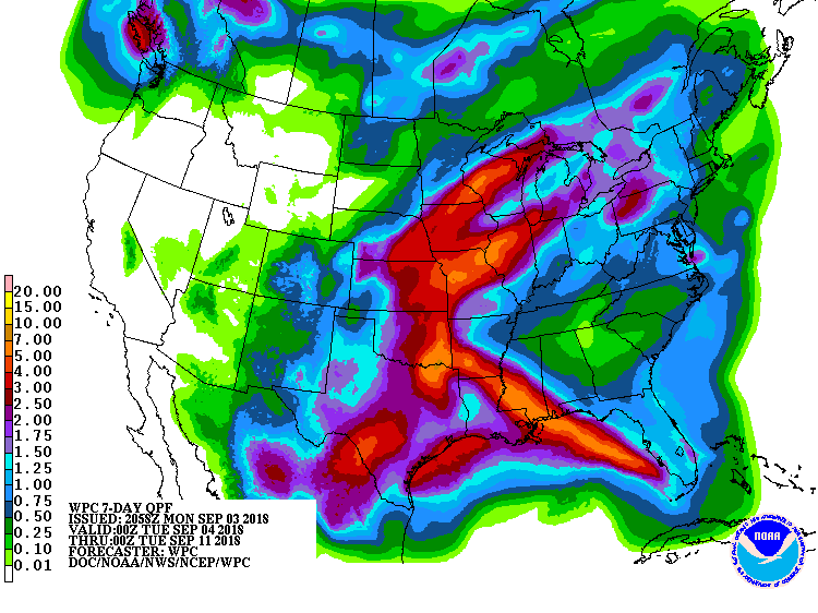
Here's a closer view with specific amounts from WPC. Remember these won't be exact. What we're interested in are the trends showing approximate locations and amounts.

With the recent onslaught of rain, rivers have been rising fast and many are expected to reach moderate flood stage (if not higher) in coming days. As of late Sunday these flash flood watches and river flood warnings were in effect over a large swath of the central Midwest. These could be expanded or retracted based on rains in the coming 24-48 hours.

WPC also has chances for excessive rain in some part of my local area into mid-week.

Notice the large area where significant river flooding is likely or is occurring.

Even through days 3-7, WPC is pointing towards more flooding in my area. However, much of it is likely due to run-off from previous rains entering the channels of larger rivers and streams.

Later Wednesday or Thursday the worst of the heavy rain threat may shift south of my area. The GFS is very bullish calling for a break, the EURO not so much. The remnants of tropical storm Gordon and its eventual track out of the gulf will be a critical factor as to what happens going forward. Right now the intense rains generated by Gordon look to stay just south of my local area in Missouri and central Illinois. We'll know more later Tuesday. Roll weather...TS


