


CONE OF UNCERTAINTY....
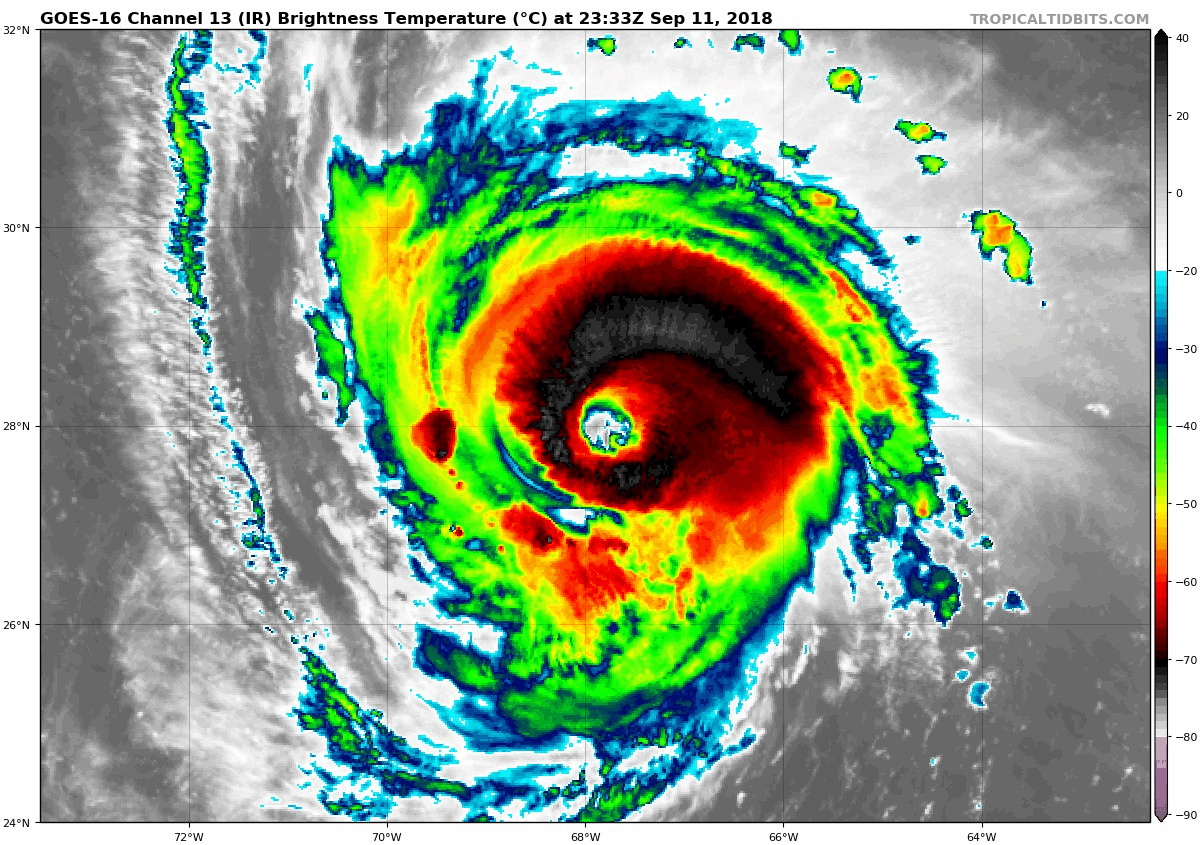
Florence is kicking up a fuss in the Atlantic as she takes aim on the southeast coast of the United States. For the moment, the fuss is not about the intensity but changes in track some of the models have shown. Here's what the Hurricane Center had been showing for several days. A very consistent landfall near Wilmington, North Carolina.

Now look what the GFS has gone and done. It takes the center just off the N.C. coast and then stone cold stalls it as if it hits a wall. Then it makes a hard left and rides the S.C. coast until turning inland north of Charleston. Wow, that's a radical change with big implications.
If that isn't bad enough, the EURO was just as dramatic showing a very similar solution with a stall, a turn, and a landfall near the Georgia, South Carolina border. That's even further south than the GFS and it would spare parts of North Carolina from significant impacts.
Most of the models are now sniffing the trend. Notice how the spaghetti plots were centered on North Carolina on the 6z model runs.

18 hours later the 0z runs are showing this. Not only is there a significant shift south there's also more spread in the solutions.

What it means is a sigh of relief for some and gulp of angst for others. I would also imagine forecasters at the Hurricane Center are scrambling to get a handle on these important trends. I've noticed their cone of uncertainty has expanded west and south as doubt begins to grow on the path and speed of the storm.

If there's one thing that's certain, it's that uncertainty remains high just 2 days before landfall. As it stands now NE South Carolina or SE North Carolina stand the best chance of seeing landfall. Some models have it making landfall on Thursday evening, others have it spin in the Atlantic until Monday! Depending on exactly what happens, it could have an impact of 1 day or up to 5 days, and rainfall measured in inches or feet! This is still a very dangerous and high impact storm for those in its path.
As I mentioned in my post yesterday the rex block that's influencing Florence is also dictating weather conditions over the Midwest. With the sluggish pattern holding into next week it's steady as she goes with more sunshine and no rain. The only change I see is a gradual uptick in temperatures and humidity as we enter the weekend. Enjoy and as always, roll weather...TS


