NO REST FOR THE WEARY THE REST OF WINTER....
- terryswails1
- Feb 20, 2019
- 3 min read
Our latest batch of snow and winter weather is in the process of pushing out of the region early Wednesday. With our recent flaky addition, the seasonal snow total in Cedar Rapids is now on its way to 50". If and when we make it, 2018/19 will go into the books as the 10th snowiest on record. The all-time mark as you can see is 62.4" set in the 1959/60 season.

With roughly a month to go in winter, there's no sign that the active pattern that's produced more than 40" of snow in the past 40 days is breaking down. In fact, the SOI (Southern Oscillation Index) hit -43.6 Tuesday. That's a sure indication of a very energetic pattern that is likely to bring both snow and cold the next 10 days.

Another feature I've been watching closely is the evolution of the MJO (Madden Julien Oscillation). Persistent convection west of Australia has finally moved east. With higher pressure in its place that has initiated the falling SOI levels and sent the MJO on a journey that takes it through the cold late winter phases of 1, 2, and 3 between now and the March 22nd (the end of winter). You can see the swing by following the dotted green lines below. On the right are the temperature anomalies for phase 1,2, and 3 heading through February and March.

Another teleconnection to watch for colder weather is the EPO (Eastern Pacific Oscillation). As you would expect with the coming "cold" MJO phases it's shown going strongly negative on both the EURO and GFS. The GEFS EPO forecast is more than 6 standard deviations below the baseline of zero. That could mean an Arctic outbreak is looming by the end of February. Here's the GEFS EPO forecast.

This is the EURO version of the EPO forecast.

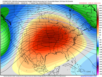
Below you can see the type of storm track and weather associated with the negative phase of the EPO. That looks plenty wintry!

Clearly there are a lot of key long range teleconnections that are signaling a cold and rather stormy period ahead. We shall see soon enough.
Speaking of the next storm, it's projected to be one of the strongest of the winter. Ironically, it could be on a track that delivers the heavy snows just to the northwest of my area. You can see below a deepening surface low on the GFS reaching 980mb as it cuts northeast out of Kansas into eastern Iowa on its way to Wisconsin.

Barring some sort of southward shift, the issue for most of my area Saturday and Saturday night on the GFS would be heavy rain. That falling on top of 8-20" of snow is bound to cause run-off issue. Here's the total precipitation forecast on the GFS for the weekend storm, most of it rain for my region. That's a little concerning to say the least.

This is where the GFS shows the heaviest snows. A real break not to get blasted with that!

Now, here's an important new twist. The latest EURO just in has made that southward shift. In many respects it makes sense to me with the very deep snow cover that extends across much of Iowa. The snow produces a cold feedback that keeps the baroclinic boundary (storm track) located on its southern edge. As you can see tonight's run does that by taking a 993mb low to Springfield, Illinois. From there it deepens to 985mb as it heads to Milwaukee.

That track still brings rain to eastern Iowa but it also implies some intense dynamic cooling as the low passes east that would change rain to snow, especially over central and eastern Iowa. The EURO shows a heavy band of snow west of a line from Dubuque to Iowa City and Ottumwa. That is significantly further south than previous guidance or what the latest GFS shows.

Since we are a few days out there are still some very significant issues to work out regarding track, intensity, and precipitation type. This is going to be a very interesting and challenging forecast. I'm very intrigued to see what Wednesday's modeling does regarding the EURO's shift south. Who knows, maybe it goes back north in coming runs but for now this has added some real drama to the weekend forecast in my area. Roll weather...TS


Comments