


ROUND AND ROUND WE GO...
For the first time this year the summery combination of heat and humidity has come to the Midwest. Check out the past 7 days, above normal readings for much of the corn belt. The crops have been loving it (as have many a farmer) following months of cool wet weather.

The northern fringe of that heat has established an active storm track that's impacted the upper Midwest. You can see where repeated rounds of thunderstorms have dumped excessive rains over much of Minnesota, Wisconsin, and NE Iowa the past 7 days.

The remainder of the week will see little if any change as the storm track remains in the same general position through Saturday. This is the projected 500mb jet stream flow Thursday July 4th. Round and round we go.

Aside from warm humid conditions, this will also ensure chances of showers and thunderstorms on a daily basis. The animation below shows how the rains accumulate over the next 7 days as repeated rounds of storms add up.
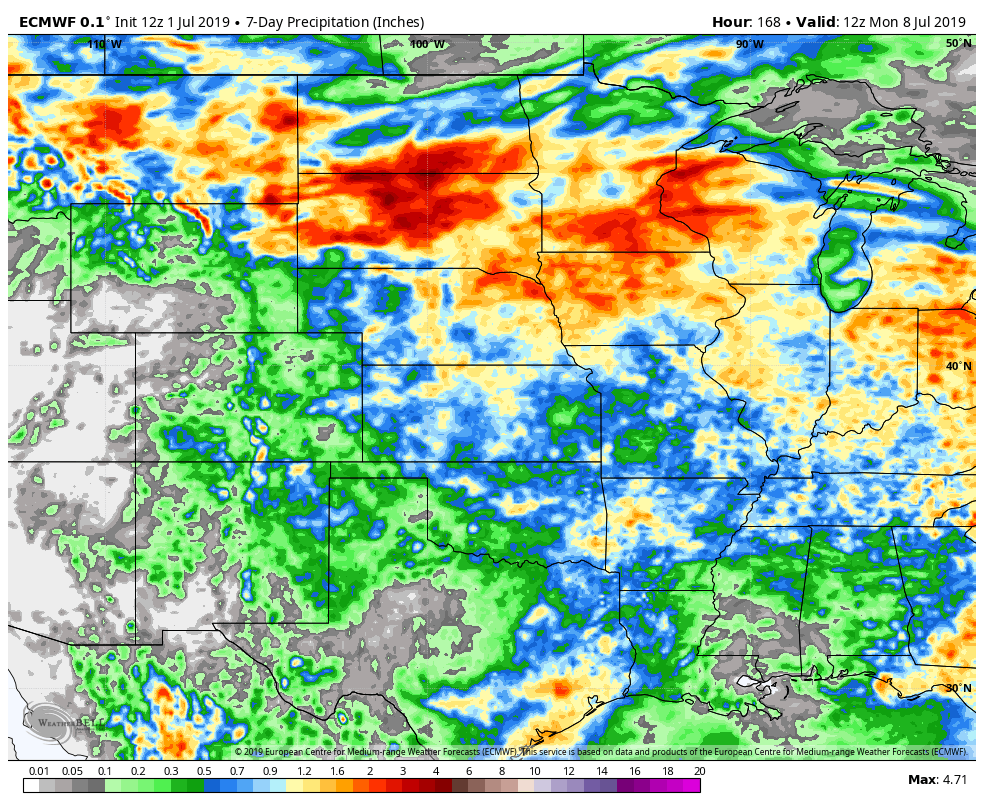
Here's the totals over the 7 day period off the EURO.

These are the 7 day departures.

With the holiday approaching many of you have plans involving the great outdoors. Unfortunately, it's very hard to time storms out 24 hours in advance, let alone 3 to 4 days. However, the general trend is for storms to be most numerous and strongest during the late afternoon or evening when instability peaks.
As it stands now (and this is subject to change), the 4th appears to be the day when rain chances are highest in my local area. I do not see a washout or an all day rain but at some point a shower or storm is a good possibility. The EURO shows this for surface features at 7:00pm Thursday.

The GFS has this for the same time period. Green indicates rain.

The EURO has this for highs the 4th.

The GFS is a bit cooler, but still very muggy.

By Sunday a front is expected to penetrate the Midwest bringing a push of cooler and drier air. Conditions should be quite pleasant as the first round of summer heat and humidity breaks across the Midwest. Roll weather...TS


