


GETTING LOUD AND PROUD BY HALLOWEEN...
BIG THANKS to those of you who have paid the voluntary subscription fee to keep TSwails going. Your exceptional generosity is extremely appreciated. My goal going forward is to work full-time on the site, build it, add new features, and be my own boss! If you can, please consider a voluntary subscription to TSwails of $12 dollars a year ($1 dollar per month). The future of the site is dependent on your contributions. We hope you see the value and hard work that exists in the daily content. There are new features currently in development that I think you will enjoy. Thank you so much for your consideration and help. To subscribe click on the secure green box below.

TODAY'S FEATURE POST
After a frosty start to your Thursday, the weather is going to warm up for a few days just in time for the weekend. Here's why. This is Wednesday nights 500 mb jet stream pattern. A vigorous trough is pulling some chilly air into the Midwest.

The trough is progressive and by Friday its replaced by a ridging as another powerful system digs into the west.

You can see the southerly winds blowing all the way to Hudson Bay. That transports warmer air into the center of the nation.

Highs Friday are projected to be in the 60s all the way into Minnesota and Wisconsin. They should hold there into Monday of next week.

Unfortunately with the warmer air comes moisture. As that western storm moves east, it pools ahead of it over Iowa Monday with water vapor (PWATS) exceeding 1.25" in the southeast.

Those PWAT values are about 2.5 times greater than normal.

That means rain will be back in the forecast Saturday (especially in the morning) and then again on Monday as that potent western energy plows east. Sunday should be dry.
Between the 2 rain producing impulses, the EURO shows this for rain totals. The banding indicates the potential for thunderstorms with the primary energy Monday.

Cold air won't be as prevalent up north with this disturbance but there will be enough for some snow. Here's what the EURO depicts.

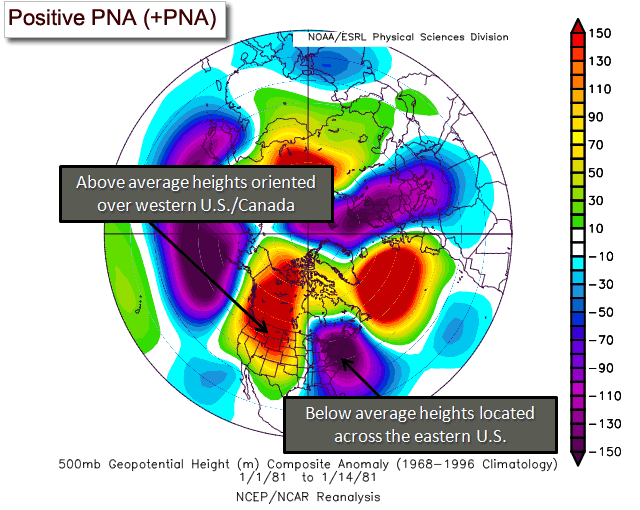
After this system departs the impacts of the Pacific typhoon and phase 2 of the MJO start to take hold bringing the long advertised cold air for the end of October. Lending confidence is the PNA (Pacific North America Oscillation) and the EPO (Eastern Pacific Oscillation). Look as the PNA climbs into a positive phase.

See the difference between the positive and negative phases below. A positive PNA depicts a trough over the east and a cold NW flow in the upper levels. The positive phase is just the opposite and warmer.
That east trough set-up is clearly established by October 28th when the jet looks like this.

Same thing for the EPO. It goes negative by that time.

A negative EPO teleconnects the same as a positive PNA ( in other words a trough over the east). You can see in the graphic below how much that resembles the 500mb jet stream flow October 28th. Classic stuff.

The bottom line is that the odds of some very chilly air just before Halloween continue to increase across the Midwest. Just look at the departures going into October 30th. Big tricks and no treats. That's a very cold look!

The Climate Prediction Center is in on the act now showing this for October 24-30.

With such intensity to the early season cold, I would expect the air to be unstable and I would be somewhat surprised if we don't see our first flakes of snow with the outbreak. It may not be much more than flurries or snow showers but that's a sure sign of the season ahead. Just for kicks, the GFS depicts this for snowfall between now and November 1st. Daddy likes!

Anyway, after a couple of pretty good days ahead, the pattern gets loud and proud the last 2 weeks of October. The times they are a changing! Roll weather...TS


