


COMPLEX WINTER STORM ON THE TABLE...
While some important details are yet to be resolved, confidence continues to grow that a significant storm will bring a wide variety of weather to the nations mid-section Friday night and especially later Saturday and Saturday night.
This system could pack a real punch and be quite disruptive to parts of my region and the surrounding area. No doubt it is going to be a challenge to forecast in terms of precipitation types, amounts, and the location of the heaviest snow. After some doubt earlier Wednesday about how the storm storm would evolve, now all models agree in principle on the general trends.
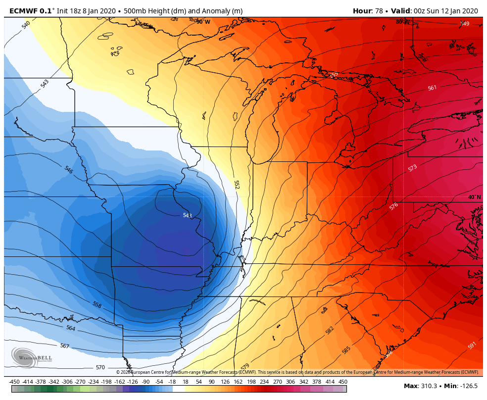
Due to their recent consistency I am leaning heavily on the EURO and 12K NAM in their overall handling of the track and precipitation shield. Both models have been staunch in taking a closed upper air low right over Quincy this weekend and that is the sweet spot for heavy snow, especially Saturday night.
There also looks to be two potential periods of precipitation. The first round in some areas could start as rain and then transitions to freezing rain, sleet. especially southeast of a line from Cedar Rapids to Dubuque. This initial wave of precip eventually mixes with or changes to snow before it moves out by Saturday morning.The best chances for a couple inches of slushy accumulation Friday night appears to be NW of a line from Iowa City and on to Freeport, Illinois. From that line southeast to the Quad Cities mixed precipitation is more likely with rain changing to freezing rain or sleet and perhaps some snow before ending. A few models show up to a 1/2" of freezing rain or sleet near the Quad Cities. This part of the forecast, especially the icing is very hard to call and much lower in confidence at this time
Accumulated freezing rain on the EURO

With that wave of energy departing early Saturday there should be a window through noon, maybe early afternoon where it's just cloudy and dry. Then the main energy ejects and that should generate snow as its precipitation shield spreads back over the region Saturday afternoon and night. The exception could be southeast of the Quad Cities where a mix would then change to snow in the evening. The surface low itself goes from south central Illinois right over the southern tip of Lake Michigan. again a prime spot for heavy snow in a deformation band that sets up over my area.

Winds will get going pretty good for a time Saturday night with some gusts up to 30 from the NE. The snow will be pretty wet initially but there could be a time Saturday night where blowing and drifting is found in the open country. By Sunday morning the snow quickly lets up and departs.
The operational EURO shows this for total snow accumulations (that includes what falls Friday night in the NW.

The 12K NAM has the general look of the EURO

The GFS is a bit further east but compared to what it showed earlier is finally in the ball game.

The key factors to watch for Thursday are any changes in track or intensity in coming runs that would move the playing field around...meaning the snow band could go east or west resulting in higher or lower amounts. That is a possibility you always worry about right up to the end. Having said that, I think if the idea of a phased storm holds like the EURO, NAM, and now the GFS show.
Another big factor with this storm is the potential for unusually heavy rains. Very high moisture levels could lead to rains of 3-5 inches in parts of Illinois. Flooding is a major concern and many flood watches are in effect.

This system has the potential to be a significant ice and snowstorm for some part of my area and I would expect winter storm watches to be issued at some point by the NWS...perhaps by the time you read this. We still have a little time to fine tune some key details but the models are very bullish and red flags are flying. So while this still has time to change some, confidence is now high for a healthy winter storm to impact a large part of my area. Stay tuned and roll weather...TS
PS... ONLY 3 SPOTS REMAIN AVAILABLE FOR WEATHER SCHOOL. GRAB YOURS NOW!

TSwails.com is offering a very special and unique opportunity to learn first-hand the ins and outs of weather forecasting with one of the best meteorologists in the Midwest along with his team of expert meteorologists.
That’s right… You want to forecast right along with Terry Swails, well now you can. He’s teaching weather with TSwails newest program called WEATHER SCHOOL. The opening bell rings this January and you can be a member of the very first graduating class. The one-day forecasting seminar for weather enthusiasts will be held at his home in January. It’s not your typical run-of-the-mill school. There will be no tests, but Terry, Rebecca, and Nick will cram your head with so much knowledge, it’ll be spinning like a tornado before the day is over.
You want to know the essential online sites to use for models, radar, and the basic weather tools? DONE! You want to understand the structure of models and the role they play? DONE! You want to be able to construct forecasts from the ground up? DONE!
WEATHER SCHOOL will be presented in a seminar-type format where you'll have the ability to ask questions and dig deep. You’ll get the scoop on data acquisition, model analysis, severe weather, and actual forecasting from the big dog himself, T. Swails. With 43 years of experience and an uncanny ability to break the science down, you’ll open the door to forecasting like never before.
Along with the head master T. Swails himself, meteorologists Rebecca Kopelman and Nick Stewart of KGAN TV will be there to lend their knowledge and experience to the discussion. It will be fun, informative, and factual! This is the day for you to see, feel, and experience what it’s like to be in the hot seat of a meteorologist.
The seminar will be held January 25th and will last from noon until 5:00pm. We have limited seating and the cost is $99 dollars per person. A catered lunch will be provided. Again..not a lot of seats so reservations with a pre-payment are required. Sorry, no refunds. If there’s enough interest, a second session will be added in early February. To register or get additional information send an email to carolynswettstone@yahoo.com
GIVE THE GIFT OF WEATHER. This might be the perfect gift for that hard to buy for person this Christmas. Along with a WEATHER SCHOOL admittance voucher, TSwails will send a special holiday greeting to your weather enthusiast if you give the gift of weather with the TSwails touch!
WEATHER SCHOOL AGENDA:
WELCOME AND INTRODUCTION
Purpose: To help weather enthusiasts understand the basics of forecasting and apply the knowledge and techniques learned to construct personal forecasts.
Session 1: DATA ACQUISITION
The essential on-line sites for models, observations, satellite and radar images, and general weather data.
Session 2: ANALYSIS:
Determining your objective goals. Short term, intermediate, or long-term. Understanding the process of analysis and its relationship to forecasting.
Model options and choices. What to use and when!
The GFS, EURO, NAM 3k, NAM 12K, Canadian, HRRR, MJO, ensembles, teleconnections, etc.
Locating, learning, and knowing what’s essential to make a reliable forecast.
The art and science of model interpretation: Using and understanding model output. Its called guidance for a reason!
Learn how to analyze key parameters such as:
Surface and upper air data
Vorticity and energy
Precipitation output
Wind and pressure
Session 3: MAKING A FORECAST FROM MODEL GUIDANCE
A simulation of the basic process using model output.
BREAK: A 25-30 minute recess to enjoy a catered lunch…
Session 4: SEVERE WEATHER:
Thunderstorms, tornadoes, derechoes, and squall lines.
Soundings. What are they and why should I care?
Instability (CAPE) vs (CIN) Critical interaction involving moisture, heating, and forcing.
Uncovering the ingredients of a severe weather set-up.
TVS signatures. What to look for on radar.
Role of SPC vs NWS, and your local TV station regarding the warning process.
Simulated model driven forecast of a severe weather event/tornado outbreak
Session 5: WINTER STORMS:
The key ingredients required for significant winter storm:
How to forecast the rain snow line.
How to forecast snow totals from QPF
Determining totals from snow ratios.
What to look for at the surface and at upper levels (500 and 850mb)
Model bias and determining the storm track
Simulated model driven forecast of a significant Midwest winter storm
QUESTION AND ANSWER SESSION
An open period for attendees to ask questions regarding relevant topics or issues discussed during the day.
CONCLUSION:
Some final words of inspiration from the events headliners
Once again, to reserve a spot or ask questions send an email to carolynswettstone@yahoo.com See you when the bell rings! Roll weather...T. Swails


