


(G.O.A.T.) THE GREATEST 48 HRS OF WEATHER ALL-TIME...
January 24-26th, 1967 marked the anniversary of one of the most remarkable weather events in Midwest history. 53 years ago an unprecedented tornado outbreak exploded over southeastern Iowa and portions of Missouri, Illinois, and Wisconsin January 24th. There were at least 13 tornadoes in Iowa with many of them producing significant F2 or F3 damage. To this day, these are the only January tornadoes ever reported in Iowa.


Two tornadoes struck Lee County resulting in 10 injuries, and one of those tornadoes produced F3 damage that killed a youngster west of Fort Madison. Another tornado produced F4 damage just across the border in northeastern Missouri before entering Davis County Iowa. Later that evening, a strong cold front swept across the region and by the 26th, snow fell across about the southeast half of Iowa with snowfall amounts ranging up to 13.5 inches at Burlington, less than two days from the significant tornado outbreak in the same area.
Here's the surface pattern January 24th showing 60s in SE Iowa and teens in the NW corner of the state. Dewpoints in SC Iowa ahead of the advancing surface low approached 60 degrees...exceptional for January and no doubt the catalyst for tornadic supercells.

The incredible turn of events from tornadoes to blizzard conditions makes this one of the most extraordinary 48 hours of weather in Iowa and NW Illinois history.
While the warm side of the storm was unprecedented, so too was the wintry side which spun up about 24 hours later. In Chicago where the high reached 65 the 24th, thunderstorms ushered in the cold front that dropped temperatures to levels cold enough to produce snow. With plenty of moisture and warmth just to the southeast, snow broke out as a new low pressure wrapped up over southern Illinois. For a number of hours snow fell at the rate of 2" per hour. By the time it ended, 23" had piled up for an all-time record 24 hour snowfall in Chicago.


Here's some excerpts on the storm from an article produced by the NWS in Chicago.
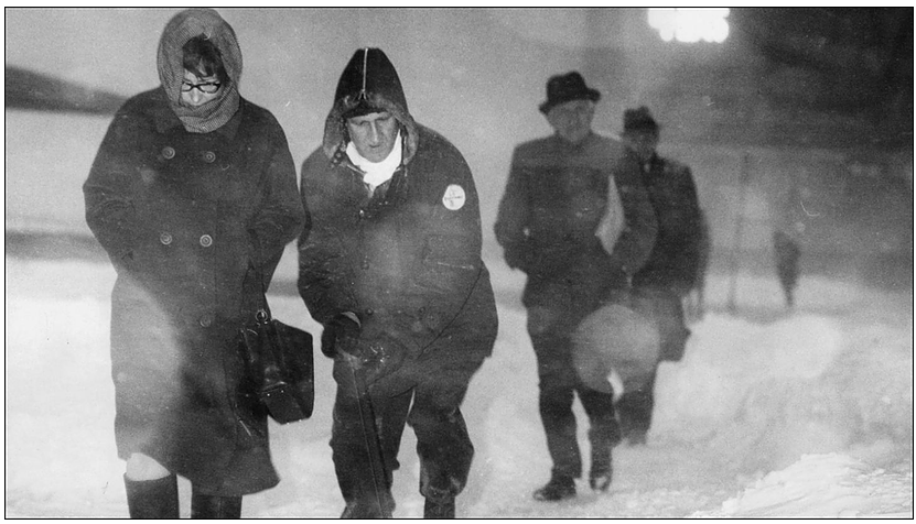
The Impact
Snow began on Thursday morning, January 26th but most people made it to work and school without much trouble. But by noon about 8 inches was already on the ground and O’Hare Airport was shut down. Some businesses and schools released employees and students early. The commute home, even for those who started early, was a nightmare. Many workers did not get home, or arrived very late. Many stayed at work or in hotels. By Friday morning the city was at a standstill. The airports and local transportation were shut down. In the city of Chicago 20,000 cars and 1,100 CTA buses were stranded in the snow. People walked to stores to clear the shelves of bread and milk. Helicopters were used to deliver medical supplies to hospitals, and food and blankets to stranded motorists. Expectant mothers were taken to hospitals by sled, bulldozer and snow plow. At least a dozen babies were born at home. Looting became a problem on the west and near south sides of the city. Another problem in the aftermath of the storm was low supplies of heating oil. Trucks couldn’t get access to buildings.
By Saturday the 28th, Chicago was beginning to dig itself out. Commuter trains were running and CTA buses were operating most lines. The city sent a workforce of 2,500 people with 500 pieces of equipment out to clear the streets. Iowa, Wisconsin and Michigan sent heavy equipment to help with the snow removal. But the thousands of abandoned vehicles hampered the clean up. Snow was hauled by dump truck to the Chicago River. O’Hare finally opened around midnight Monday, allowing people who had been stranded for days to finally get home. Most schools didn’t reopen until Tuesday. By then most transportation was back to normal.
By the time it was over, 60 people were dead and there was an estimated $150 million in business losses (about $904 million in 2006 dollars). The 1967 snowstorm probably caused the biggest disruption to the commerce and transportation of Chicago of any event since the Great Chicago Fire of 1871.

The Meteorology
On Wednesday January 25 a cold front had moved through the upper Midwest replacing the balmy 60 degree weather of the previous day with more seasonal readings. A strong 1032mb (30.48 in) high pressure center was over the prairie provinces of southern Canada. A vigorous upper level trough was moving across the southern Rockies causing a low pressure area to form at the surface near the Texas Panhandle. By midnight of Thursday January 26 the high was building into the northern plains states while the low, now at 1008mb (29.77 in) continued to develop and move east to Oklahoma. During the day Thursday the upper trough moved through the mid and lower Mississippi Valley and an upper level low began forming near the Missouri/Arkansas border. The surface low moved through Arkansas and western Tennessee and Kentucky, reaching south central Indiana by midnight Friday. The low deepened rapidly to 997mb (29.44 in) as it moved to Indiana.

Dew points in the 50s to lower 60s over the southern plains and Gulf Coast states fed the storm with ample moisture while the Canadian high pressure, now centered over Lake Superior and southern Ontario, kept cold dry air pouring into the Great Lakes. The strong pressure gradient between the high over the upper Lakes and the deepening low over the Ohio Valley caused winds to howl off Lake Michigan. This produced severe blowing and drifting of snow as well as causing lake effect enhancement of the snowfall.
On Friday the upper low continued to form and move northeast to northwest Ohio. The surface low occluded and deepened to 990mb (29.23 in) as it lifted northeast across Lake Erie and into southeast Ontario, Canada by Friday night. By this time the snow had ended in Chicago and winds shifted to north northwest and began to subside.


Far from accurate forecasts.
Forecasters had a difficult time seeing the strength of the storm and a day before the flakes flew forecasts were only calling for a 50% chance of snow in Chicago. The night before the blizzard hit still no mention of accumulations. The next morning with snow falling the NWS issued a heavy snow warning for 4 or more inches. At the peak of the storm forecasts were amended to include and additional 4-8 implying the potential for total accumulations of 8-12". By the time it ended 23" clogged the city and brought Chicago to a standstill. Here are the official NWS forecasts for the storm starting 24 hours in advance of its arrival.
Issued at 945 AM Wednesday January 25th
Thursday...Cloudy with a chance of snow especially in the afternoon. High near 30. Northeast winds 8 to 15 mph. Chance of precipitation 50 percent.
Issued at 345 PM Wednesday January 25th
Thursday...Cloudy with rain or snow likely. High in the 30s. Northeast to east winds 10 to 18 mph. Chance of precipitation 50 percent.
Thursday Night...Rain or snow likely. Low in the lower 30s. Chance of precipitation 50 percent.
Friday...Rain or snow ending.
Issued 945 PM Wednesday January 25th
Hazardous Driving Warning late tonight and Thursday...
Remainder of tonight...Cloudy and colder with snow possibly mixed with freezing rain beginning late tonight. Low in the upper 20s. Chance of precipitation 50 percent.
Thursday...Snow mixed with freezing rain likely. High in the lower 30s. Northeast to east winds 10 to 20 mph. Chance of precipitation greater than 90 percent.
Thursday Night...Snow or rain changing to snow and turning colder. Low near 20. Chance of precipitation greater than 90 percent.
Friday...Partly cloudy and colder.
Issued at 345 AM Thursday January 26
Heavy Snow Warning...
Today...Snow with accumulations of 4 inches or more by this afternoon. High in the lower 30s. Northeast winds 15 to 25 mph. Chance of precipitation greater than 90 percent.
Tonight...Snow diminishing or ending. Colder with the low near 20. North to northeast winds 15 to 25 mph. Chance of precipitation 80 percent.
Friday...Partly cloudy and colder. High in the mid 20s. Chance of precipitation 20 percent.
Issued at 945 AM Thursday January 26
Heavy Snow Warning...
Today...An additional 4 to 8 inches. Windy with steady temperatures. Northeast winds 25 to 35 mph. Chance of precipitation 100 percent.
Tonight...Snow diminishing and ending. Colder with the low 10 to 15. North to northwest winds 15 to 30 mph. Chance of precipitation 50 percent.
Friday...Partly cloudy and colder. High in the middle 20s. Northwest winds 12 to 22 mph. Chance of precipitation 20 percent.
Over the last half century, the advent of high resolution forecast models, advanced GOES satellite technology, Doppler radar, and a dense network of automated surface observations has allowed forecasters to give much more accurate warnings of snow storms with much greater lead time. That enabled forecasters in the Groundhog's Day Blizzard of 2011 to give ample warning that a serious storm was on the way. Despite the infamous photos of cars standed on a snowbound Lakeshore Drive, similar scenes were far more isolated in Chicago after the 21.2" that fell in 2011. That's because the blizzard warnings were heeded and many businesses were closed by the time snow started, allowing many people to stay home or leave work early enough to get home safely.
In my opinion, going from tornado touchdowns to more than a foot of snow in 2 days represents the super bowl of weather extremes. What a remarkable period of weather, in my opinion it's the G.O.A.T.
As far as the weather goes the rest of this week I don't see anything that will cause any serious disruptions. Some light snow is possible in parts of the area Wednesday and again Friday but in most areas little if any accumulations are expected. Temperatures will continue near to slightly above normal resulting in highs close to the freezing mark through Friday. Nothing to write home about. Roll weather...TS


