


A LATE JANUARY THAW, THEN A FALL...
The rest of the week promises little (if any) in the way of sunshine, continuing a dreary trend that goes back more than a week. The pattern also includes some some weak forcing in the form of 2 meager troughs that could kick up some periods of light snow or flurries.
The first is slated to arrive Wednesday and it looks weak. What little impacts it creates occur over my western counties where some models do try and generate up to 1/2" of snow. I'm not sold on amounts reaching that level but some spots could squeeze out 1/4 to perhaps 1/2" of snow, especially west of I-380 running from Waterloo to Cedar Rapids and on to Iowa City. Totals east of there should be minimal if any. The EURO shows this for amounts at a 10:1 ratio.

The next system Friday or Friday evening is also lacking in dynamics and moisture. If anything, it's even weaker and in most areas amounts should again be confined to a dusting or less, worst case a 1/4" based on Tuesday nights models. The EURO at a 10:1 ratio has this for totals ending in most of my area by midnight Friday.

After this nickle and dime parade departs the door is open for a couple days of warmer weather and melting snow...a late January early February thaw!
You can see the flow at 500mb bringing mild Pacific air into the Midwest, especially at 5,000 feet (850mb) Sunday.

Here are the temperature departures in the EURO Sunday and Monday. If it weren't for snow cover they would be
greater than this.
Sunday

Monday

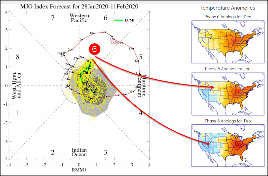
The warmth certainly fits the classic phase 6 look of the MJO. In the diagram below you can see we are in phase 6 now and to the right you can see the temperature analogs for both January and February. There is a strong correlation above normal readings and that will lead to highs that get at least into the 40s, perhaps pushing 50 in the south Monday where there will be less snow to hinder the warm-up.
The MJO does cycle out of 6 and into a null phase by next Wednesday allowing colder air to return to the Midwest. Next Thursday the EURO has a significant trough crossing the Midwest.

If the model is correct in its depiction that could open up the Midwest to a colder pattern (at least for a time) that would have some potential for snow as well. The EURO EPS control showed this for snowfall over the period January 28-February 12th. This is very preliminary and the storm track is far from certain but it shows the type of potential that exist wherever it decides to lay out. The first period to watch for any decent snow is next Tuesday or Wednesday.

On that note, I will call it a day and say thanks for checking out TSwails.com. You are appreciated! Roll weather...TS


