


ONE YEAR AGO, ALL-TIME RECORD COLD...PLUS MORE SNOW
- Jan 31, 2020
- 3 min read
I was grumbling earlier today how dreary it's been and how I can't recall the last time I saw the sun. Then it hit me, what in tarnation am I complaining about? Just a year ago we were in the midst of a horrendous deep freeze that set records for all-time cold and in some cases wind chills. Here's a little refresher in the big-chill from last years blog pertaining to the subject....
THE BIG CHILL OF 2019...
The Midwest is in the process of recovering from a historic outbreak of cold weather. Every reporting station in my area established daily record lows Wednesday and Thursday morning. In Cedar Rapids and the Quad Cities, all-time record lows were established. Additionally, here in Cedar Rapids we recorded our lowest wind chill temperature ever at -55 degrees.

Here's a model that I saved showing the forecast lows. I new it would come in handy in a year. I may never see anything like this again in my life!

There were a few places with wind chills 60-65 below.

33 below in Moline is still hard to fathom.

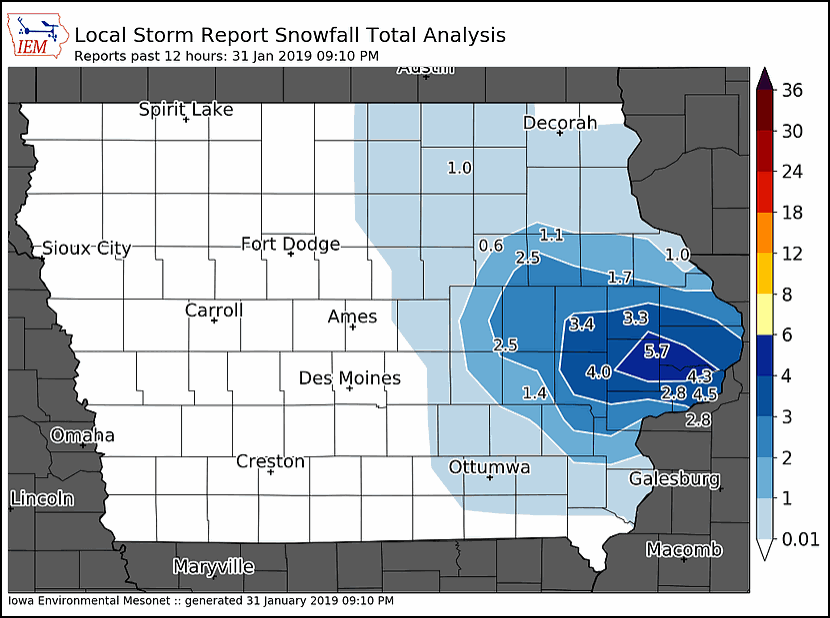
Another remarkable feature of our weather was the combination of cold and snow that occurred Thursday. Following the 30 below temperatures snow developed within 6 hours. It fell all afternoon with readings in the range of -5 to -10. With snow ratios of 30:1 the flakes fluffed up and produced a 2-5" band on a line from Cedar Rapids to the Quad Cities. I've never experienced anything like that 12 hr period in my 6 decades here in eastern Iowa. Frankly, I'm just blown away by that.
Also for you folks in the Quad Cities, I don't have the official numbers but the Moline climate site has broken the record for all-time snowiest January. If I'm reading the data right 30.2" has fallen breaking the old mark of 26.7 set in the legendary winter of 1979. You also broke the November all-time mark with 18.4". Turning into an epic winter over that way friends! Could Mississippi flooding become an issue this spring?
Wasn't that an epic stretch of weather....
I've been on the road all day today and my tank is running low so the last thing on my plate is to touch on 2 potential snow systems. The first has sprung up rapidly and should produce some snow accumulations Friday afternoon and evening, especially near and north of I-80. My guess is amounts generally in the 1/2 to 1.5" range. The euro below has a few spots with as much as 2". Since previous runs had 1/2" or less this is a big jump and my confidence is far from high. We'll have more data in the morning to confirm the trends before the snow arrives. Look for that.

The next system I've been talking about for a couple days is looking more and more probable late next Tuesday, especially Tuesday night. At this distance totals a far from certain but the potential seems to mounting for a band of 2-5" accumulations in some part of my area. This will be better resolved in the next 24-48 hours but there is very good consistency in the snow forecasts which you can see below. Additionally, these are 10:1 ratios. Using the Kuchera method which has higher ratios amounts are an inch or two higher! We shall see.
The EURO:

The GFS

The Canadian GEM

Anyway, that's all I have for now. Lots going on and you can bet I'll have more on the latest trends in future posts. Roll weather...TS


Comments