


PIECING THE PUZZLE TOGETHER...
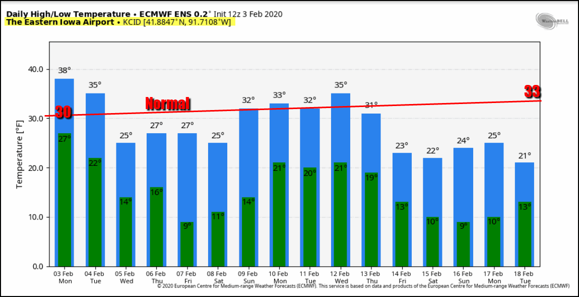
After a little hint of spring in our temperatures the past few days it looks as if we are heading into a period where readings will average near to below normal the next 14 days.The EURO has this for highs and lows. Only a couple days above freezing and a bunch more in the 20s.
The downward trend (if it does indeed materialize) would be the direct result of the EPO (eastern Pacific oscillation) trending negative. Notice how since early December that teleconnection has remained largely positive.
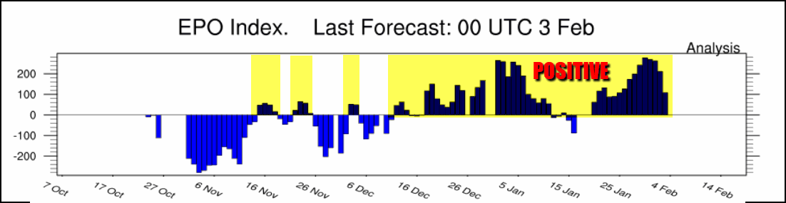
Over the past 60 days (2 months) the positive EPO has been associated to temperature departures running 4-8 degrees above normal.

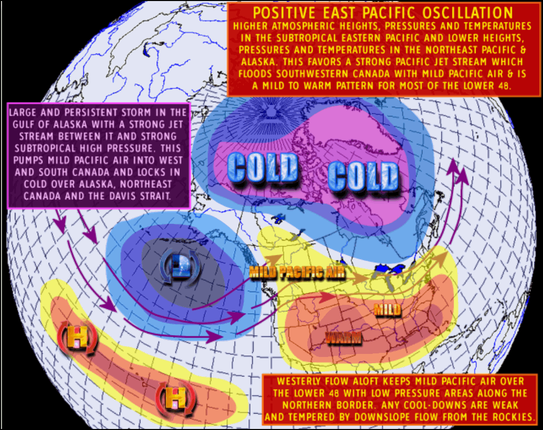
It makes sense when you look at the type of jet stream flow the positive EPO brings. With a strong trough over Alaska it's kept the flow aloft coming consistently off the Pacific. That seeds the U.S. with mild oceanic air masses as opposed to those that originate in the polar regions of Alaska or the Arctic.
Now you can see that the EURO, Canadian, and GFS are pointing to a negative phase of the EPO. If this change happens it implies a colder temperature pattern in the making. Here's the various forecasts.
The EURO EPS ensemble

The GEFS ensemble

The Canadian ensemble

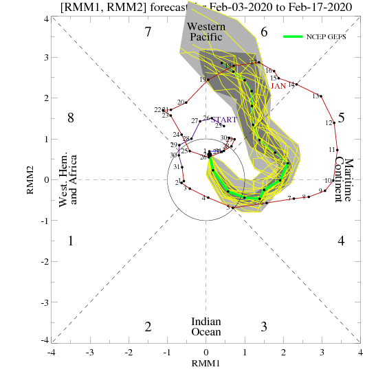
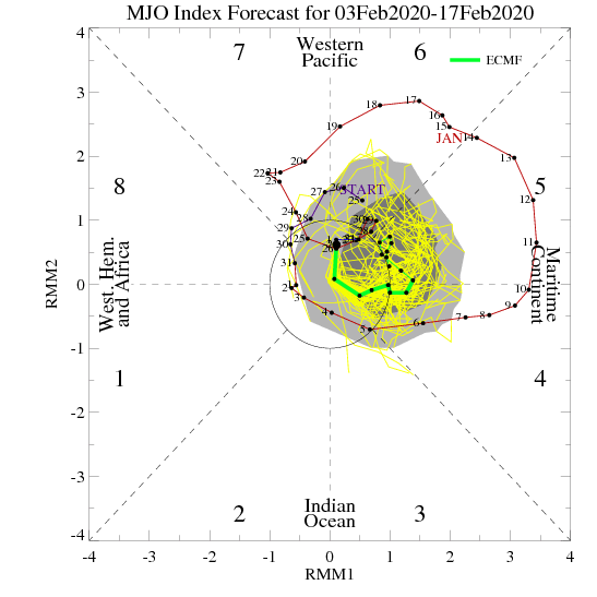
What troubles me, and gives me hesitation this will bring the type of cold it should in February, is again the MJO. The Madden Julien Oscillation on the US based NCEP forecast is highly amplified in the warm phases of 4, 5, and 6.
The EURO has a tamer look but still not the type I would associate with below normal temperatures.
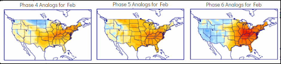
Just look at what the temperature analogs produce for phases 4, 5, and 6 in February. Toasty....
So basically we have a real contradiction as to why the models are developing the negative EPO when the MJO is locked in phases that don't support it. My feeling based on the winter so far is that any move into negative territory by the EPO is is likely to be brief as long as the MJO is in warm phases. It may also be more tempered (less amplified) than models are showing. I could rationalize some could intrusions from time to time but I don't see how it can be too severe and hold on for long until the MJO decides to make a move into its colder phases. This is just one more example of contradiction in a winter full of false leads and hope. I'm nut buying long term trends of cold until the MJO says it's time.
If that frustration is not enough, models continue to struggle this winter with phasing issues. Lack of it killed what looked like a promising snow system for today just a couple days ago. Now, models have jumped on another piece of energy they indicate will produce snow in some part of the Midwest Wednesday night and early Thursday. At this point the data indicates a track that would put most of the accumulating snows SE of a line that runs from Cedar Rapids to Dubuque. The greatest chances of and inch of two exist SE of a line from Ottumwa to the Quad Cities and on to Freeport, Illinois. We should have a good handle on trends tomorrow. That said, these are the latest snowfall forecasts which will need updating later Tuesday.
The EURO

The GFS

The Canadian (GEM)

With all that, I will welcome sleep and a new day of energy and perspective Tuesday to get the pieces of the puzzle where they belong. Have a good day everybody and roll weather...TS


