


60 BELOW ZERO, STRAIGHT UP...
Back in 1996 the Midwest was just coming out of a vicious Arctic blast that kept temperatures below zero for over 120 consecutive hours in some areas. All-time record lows were established in most areas which stood until last years deep freeze. I was in the Quad Cities at the time and remembering watching the thermometer sink to minus 28.

The morning before, the core of the cold was in Tower, Minnesota where with clear skies, 4 feet of snow, and light winds the mercury tumbled to a mind boggling 60 below. That is the coldest temperature ever recorded in Minnesota state history. That is saying something!

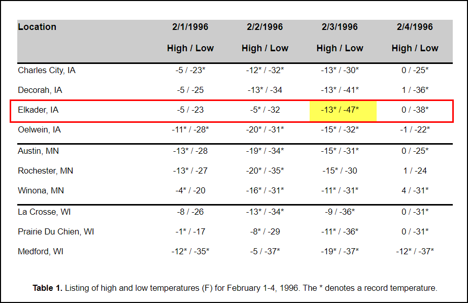
The coldest in Iowa was -47 in Elkader. That was good enough to tie the record for the coldest temperature in Iowa weather history.
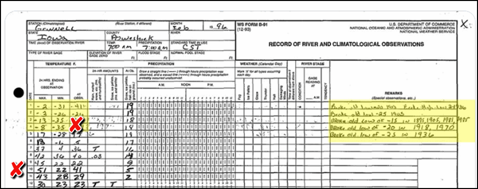
In an unusual twist, Grinnell, Iowa went from a low of 35 below February 4th to a high of 51 the 10th. That's a warm-up of 86 degrees! All of us around the Midwest were pretty pleased about that.
Well, today the focus won't be on cold (although it will be chilly) as much as snow chances for the SE half of my area. It's tied to a complex interaction of energy and moisture that will bring a big snow to places close to St Louis and Chicago.
The northern fringe of this snow band will clip the SE 1/2 to 1/3 of my area Wednesday afternoon and night. The big key on how far north this event gets is the depth of dry air that is building slowly southward Tuesday night. The dry air will act as a wall and create a very sharp cutoff to the northern edge of the snow somewhere near the Mississippi River in southeast Iowa. 24 hours ago the Quad Cites was in the heart of the band and now it appears could just be on the very fringe. Another shift of 25 miles in the final track could make the difference in the QCA of 1-2" or just some flurries. Counties all along the NW fringe of the snow band will see similar sharp cut-offs.
So what I'm saying its this...its impossible to call the cut-off line this far in advance. Models are just not good enough at this distance to pin point the exact delineation. So, we will need to keep an eye on radars and short term trends tomorrow morning to get the fine line of who's in and who's out. I can say I don't expect much if any snow northwest of the Quad Cities. In Iowa only the extreme SE part of the state gets in on snow. In Illinois, most areas SE of a line from the Quad Cities to Sterling and Rockford should see accumulations. The further southeast you go the heavier. It still seems like the zone from Macomb to Princeton east has 2-4" potential. Again, all this is dependent on the track holding firm. A slight shift further southeast and the Quad Cities could miss out entirely.
Here are the latest raw snowfall forecasts I have for you from the models late Tuesday night.
The 3k NAM

The 12k NAM

The EURO

The GFS

The Canadian GEM

For the here and now that's what I have for you. New data will be out around mid-day Wednesday. It's feast or famine on this storm. You are in or out of the snow band in a hurry. Updates tomorrow. Meantime, roll weather...TS


