


THE FINE LINE...AN UPDATE ON SNOW IN THE S/EAST
If there is one thing I've been hammering home its that this snow system that splits my area later today has a sharp cut-off line that makes it a real bear to forecast. If it weren't for that fact it would be a rather basic system with 1-3" totals and all the traditional trappings of a low to mid range intensity snow system.
So what do we know with all the new data down from today's models? First and foremost there is a bunch of dry air in place in the northwest half of my area (especially NW of the Quad Cities). That part of my area will see little if any snow. Perhaps a dusting in spots SE of Iowa City, particularly the closer you get to the Quad Cities.
It's near the Quad Cities where the challenges set in as that's where the wall of death is setting up for accumulating snow. It's lined up SW to NE from roughly Keosauqua to near the Quad Cities and on to Sterling. It seems slightly further east than yesterday and that really puts snow totals in the QCA in jeopardy. The EURO still has close to an inch but I have doubts about that. Let me show you the various model solutions for snow late this afternoon and tonight and then I will summarize.


Of the 6 models, I took the average of the raw forecasts for the Quad Cities and it came out to .6 (just over 1/2") of snow. Two models had nothing and two had 1.2". So that's your range, zero to 1.2". With a fine cut like that we'll just need to see how it sets up on radar later today and watch it evolve. It would not surprise me if it turns out that little if any falls in the Quad Cities and dry air rules.
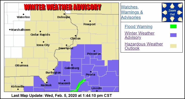
Further south the odds are much better for 1, maybe 2" east of a line from Keokuk to Kewanee. I can see 2-3" totals from near Macomb to Princeton. Again, this won't be perfect but that's my best attempt. Hopefully the dry air is not stronger than advertised and the snow line does not advance any further east than this, It is a possibility even at this late hour. Advisories are in effect for these areas and roads will get slick as the day and evening wears on.
That's the latest and greatest. Now we wait for fate to make the final call. Roll weather...TS


