


LET THE PARTY BEGIN...WINTER STORM UPDATE!
The winter storm that will bring snow, wind, and bitterly cold temperatures is moving into my southern counties now and will be lifting northward during the day. Here's more on what to expect.
SNOW
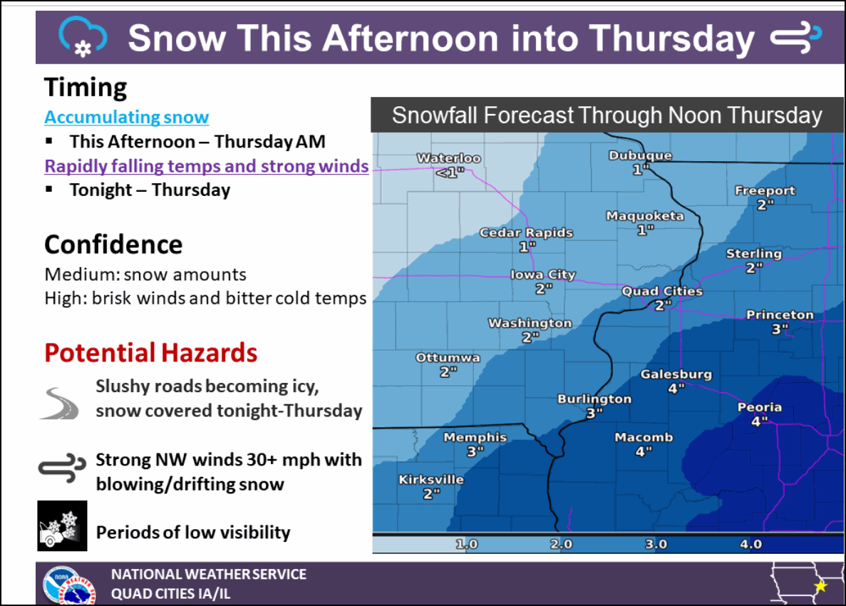
The snow aspect of the storm is not extreme. The totals which for many will be in the 1-4" range warrant winter weather advisories as opposed to warnings. For most of my region in Iowa 1-2" totals are expected except in the far southeast where 3-4" amounts are likely near Burlington, Ft. Madison, and Keokuk. From the Quad Cities southeast 2-3" totals are likely with a couple of my counties down near Macomb, Galesburg and over to Princeton in that 3-5" category. The snow is starting in my southern counties but it's going to take much of the afternoon for it to reach my northernmost areas.
With temperatures initially near freezing the snow starts wet but with time gets progressively drier as cold air gets pulled into the system. With occasional snow and snow showers much of Wednesday night and into early Thursday there will be enough powder for blowing snow to develop along the advancing arctic front.
Here's the latest GFS and its snowfall forecast. This might be a little bullish by 1/2 to 1", especially in the NW. Will need to monitor this the net few hours.

The official NWS forecast from the NWS Quad Cities has this.
The NWS out of Des Moines shows this for snow.

FRIGID AIR
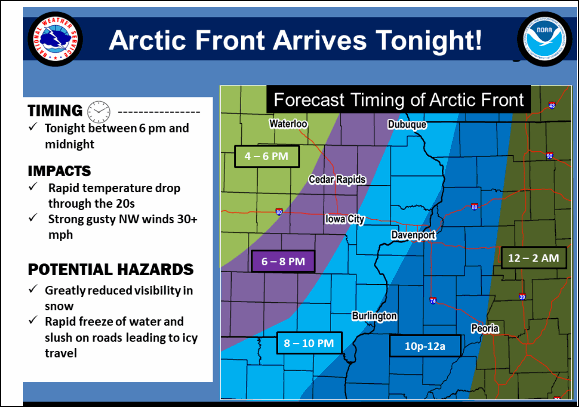
The arctic front hits my western counties toward mid evening Wednesday and quickly streaks southeast hitting the Mississippi by midnight. Temperatures will rapidly fall and by morning the GFS shows lows in my area ranging from 10 below to 13 above in the southeast

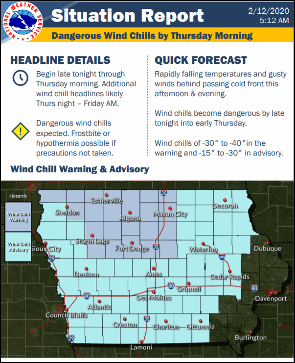
Wind chills will be serious and warnings and advisories are likely with some wind chills in NC Iowa shown as lows as 45 below. Most of my area 15-30 below zero!

Friday morning lows could be in that 10-20 below range with fresh snow cover and much lighter winds.

THE WINDS
The arctic air will generate plenty of wind. 10 meter gusts just above the surface show speeds of 30-40 mph. With the intense cold squeezing out moisture snow squalls are possible that combined with the winds could create blowing snow sharply reducing visibility at times, particularly in the open country. Anybody traveling Wednesday night needs to be properly prepared for the cold, especially in my northwest counties where the cold could be deadly for anybody exposed for only a short period of time. Highs on Thursday won't get above zero in my NW counties.
That's what we have to look forward to the next 48 hours! Sounds like fun...not! Roll weather...TS


