


BABY, IT'S COLD OUTSIDE...

This Valentines Day weekend you will "love" the President's Day specials going on at Chestnut Mountain Resort in Galena. There's something for everybody and that includes plenty of snow. There's currently a 42-68" base and some fresh Galena powder. There's never been a better time to plan a trip to the Midwest's Premier Year Round Resort. Tell 'em TSwails sent you, with love!
THURSDAY'S FEATURE POST
The coldest air of the winter is slashing a trail across the Midwest. It was preceded by snow Wednesday that accumulated 1 to 4" from northwest to southeast across my area, Here are some of the preliminary snow totals reported as of !:00 am Thursday. from the Iowa mesonet.

Now a stiff wind is tugging sub-zero temperatures and eye popping wind chills into the region. No doubt about it baby, it's cold outside and we all need to prepare for a day of frigid temperatures! Early morning readings should look something like this. Not a pretty.way to start your day.

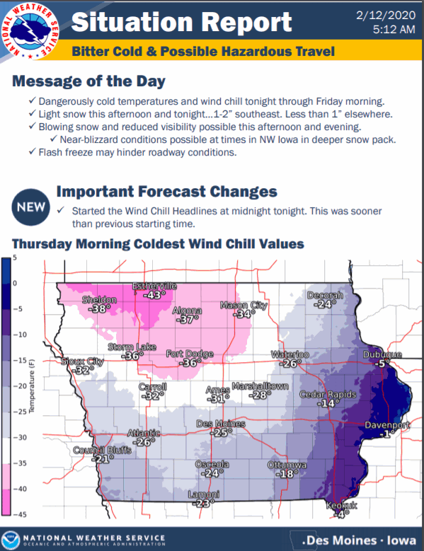
However, it gets even uglier. Throw in the wind and you get wind chills that are substantially colder. Some as low as 46 below in NC Iowa. I'm already seeing it verify as I write this with Estherville, Iowa reporting a WC of -44 at 1:00 am. These are projected wind chills at 9:00am Thursday morning.

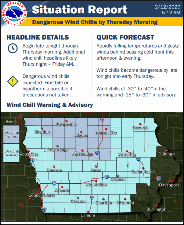
Wind chill warnings and advisories have been issued for much of Iowa as you can see in the lower portion of this graphic from the NWS in Des Moines. These could be expanded further east by the time your read this.
With strong cold advection continuing all day Thursday's temperatures will have a tough time rising much. Readings in the NW half of my area in Iowa may never get above zero. The GFS shows this for highs.

By evening Thursday, temperatures will be more than 45 degrees colder than 24 hours earlier over some parts of my area.

With much lighter winds and snow cover Thursday night, radiational cooling should be sufficient for some lows to reach 15 below in my Iowa counties. No thanks!

Return flow will commence Friday and by Saturday readings are projected be back up around the freezing mark and close to normal.
Overall temperatures should remain at seasonal levels into early next week as we await the next weather maker.
Speaking of that, Wednesday morning the EURO and GFS both were showing some good snows around my area net Tuesday but the night runs are much warmer and paint more rain than snow in my area..the whole storm is just less organized. With so much variation in solutions the past 12 hours I don't see any reason to say much more than there is plenty of uncertainty and we are going to need a couple days of a consistency in solutions to bring confidence to the table. I suspect we'll have a better handle on trends later Thursday. Until then, stay toasty and roll weather...TS.


