


A BREEZY BOUNCE UP...

This weekend you will "love" the President's Day specials going on at Chestnut Mountain Resort in Galena. There's something for everybody and that includes plenty of snow. There's currently a 42-68" base and with warmer temperatures arriving conditions should be ideal on the slopes . There's never been a better time to plan a trip to the Midwest's Premier Year Round Resort. Tell 'em TSwails sent you,on a quest to enjoy Galena gold!
RECORD HEAT IN ANTARCTICA
In some disturbing global news, earlier this February researchers in Antarctica recorded a temperature of 64.9 degrees Fahrenheit, which would be a record if confirmed. Now, however, different Antarctic researchers already may have surpassed it. Brazilian scientists on Seymour Island in the Antarctic Peninsula recorded a temperature of 69.3 degrees on February 9, which would be the first time the Antarctic has gone above 20 degrees Celsius, or 68 degrees Fahrenheit. Some quick caveats: Neither temperature has yet to be confirmed by the World Meteorological Organization, and the Washington Post reports that the higher temperature may not make the cut. Among other things, the temperature gauge sits 1.5 meters above the ground, instead of the usual 2 meters, which could have impacted the reading.
Still, it nonetheless confirms that unusually warm weather hit the continent in February. "We are seeing the warming trend in many of the sites we are monitoring, but we have never seen anything like this," says Brazilian researcher Carlos Schaefer of the latest reading.
These were the Antarctic temperature departures the day of the 69 degree reading. In some areas they are off the scale warm at the bottom of the graphic.

WARMER WEATHER HERE
Back in the homeland, warmer air is invading the Midwest and that is very good news. Friday morning lows of 8-16 below were very common across my area. Galena dipped to 18 below and was the cold spot! Cresco in NE Iowa sank to 28 below and was one of the coldest places regionally. Hibbing, Mn. enjoyed a refreshing minus 32.
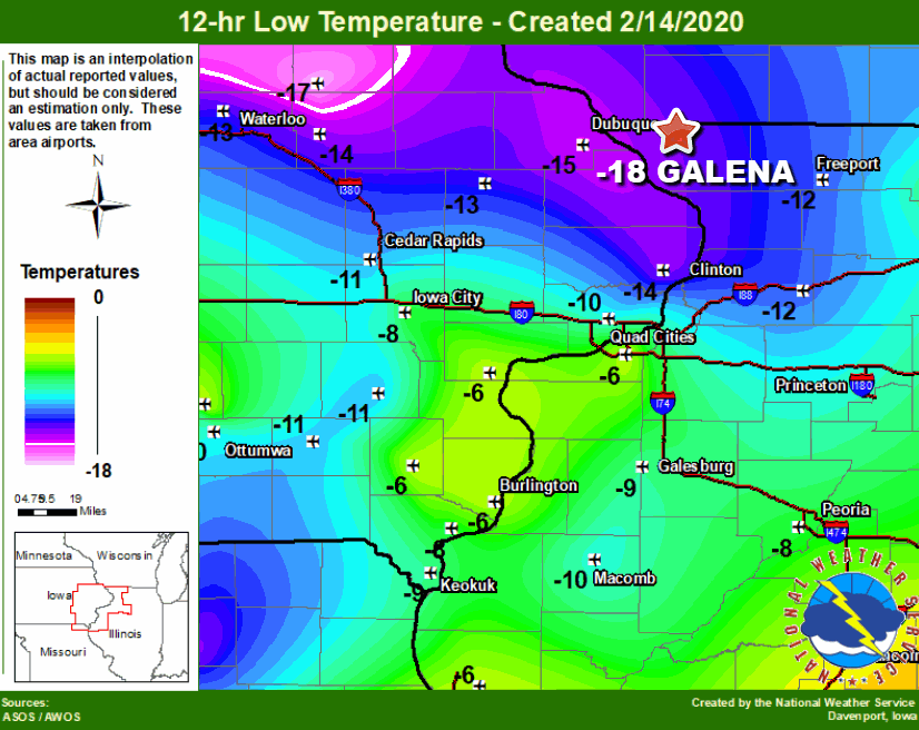
Sub-zero lows made it well into Missouri and Illinois.
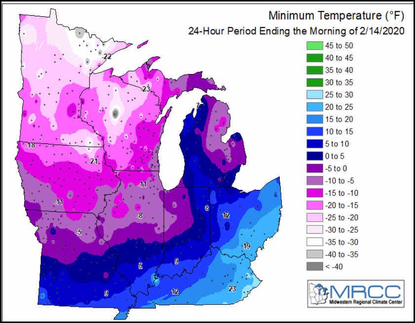
Saturday will see a nice improvement in readings as brisk SW winds send temperatures near and even above freezing in the south. Temps late afternoon should be 25-30 degrees warmer than what we saw Friday. A breezy but worthwhile bounce. Here's the 24 hour departures.

This is what the GFS projects for highs.

The warm advection that drives the higher readings will also bring some clouds and perhaps even an isolated brief rain or snow shower. Nothing to be concerned about.
PRECIPITATION CHANCES
Sunday is dry as a front dips southeast and then stalls in Missouri. Eventually it will be the focus for a complex disturbance late Sunday night and Monday. Moisture and dynamics are slightly more impressive but cold air is lacking. That means precipitation may start briefly as light snow and then rapidly transition to rain from south to north Monday morning as warmer air sneaks into the system. The depth of the warm air and how far it gets into the area will determine any accumulations. We'll need to keep tabs on it but current indications have the bulk of the snow staying north of my area. The model consensus is for most of the accumulating snow to remain north of HWY 20. The EURO shows this for accumulations.

The GFS has this for totals.

LONGER TERM TRENDS
After this system passes the rest of next week turns colder (but not extreme). No signs of any significant storm systems until next Sunday or Monday (the 23-24th) For now that's what I have for you. Have a sensational weekend and roll weather...TS


