


ONE MONTH TIL SPRING! WHAT'S TO COME...
The sun was back out around the region today. A nice change from the sloppy dreary crud we dealt with Monday. While most of my area avoided snow with the system it did fall in earnest of to the north. Here are the snowfall totals coming out of the NWS. There were pockets where as much as 6" did come down. Most of the area north of a line from Freeport, Illinois to Dubuque, Strawberry Point, and Clear Lake had 2-4" amounts.
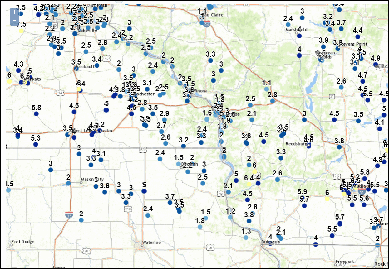
Iowa Mesonet totals

The snow coincides with colder temperatures that have returned the Midwest. These are the temperature departures over the past 7 days.

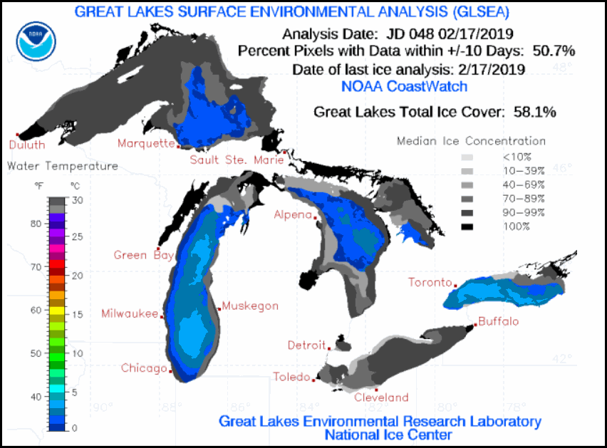
The colder air allowed some ice growth on the Great Lakes but overall mild air has kept it to a minimum. As of the 17th only 18% of the lakes had ice cover.

That's a far cry from last year when surface ice covered 58.1% of the Great Lakes. At its peak, that number reached 80.9 precent
Below you can also see 2014 and 2015 were also big years for ice, especially 2014 when coverage reached 92.5%. Only the winter of 1979 saw more at 94.7%.
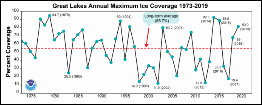
By the way the long term average for ice coverage is 55% so we are far from that at 18% Monday.
The forecast does show the potential for ice growth with 10-15 day temperature departures that are expected to look like this on the GFS ensembles.Much of my area 12-18 degrees below average February 28th to March 4th.

That's a big change in a winter that is running in the top 10 warmest in some parts of the MIdwest. The reason cold is expected back into the pattern is the EPO (Eastern Pacific Oscillation). Since December the EPO has been in a positive phase. That's allowed a fast zonal flow that has kept Arctic and Polar intrusions from getting deep into the Midwest. We did see a drop in the EPO the last week but now its temporarily on the way up again. That implies mild readings returning with that positive spike which maxes out around the 22nd. After that the dive begins into negative territory and that foretells colder weather for at least the first week of March. Thus the brisk look to that day 10-15 departure.

If the U.S. climate model the CFSv2 is right the chill should be around much of March too. This is what the latest run looks like with regard to temperature departures for the month. Not a very springlike look!

Short term the weather appears pretty quiet through Saturday. Cool to start and then warmer by the weekend.Some snow is possible just to my west Wednesday but nothing more than a few flurries is shown in my area.
After that a couple of strong weather systems threaten some part of the Midwest Sunday and again Tuesday. Model inconsistency abounds with track and precipitation type. As of Tuesday night the Sunday system looks to hold its rain and a bit of snow mainly south of the Iowa border.
Then a complex interaction of energy could yield a decent storm for some part of the region Tuesday. As has been the case many times this winter. phasing will play a critical role in the storms potential strength and track. It could be several days before that is ironed out but I would hope we at least start trending towards a more consistent solution than what the models are offering tonight. For example the EURO depicts 0.36" total precipitation in Waterloo, Iowa while the GFS has a whopping 2.48". Considering it's the GFS going wild I would assume it's on the wrong scent.
Alright, that is all I have for now. Remember we have a new weather school, "Severe Weather 101" coming up as well as this years tornado chase in May. You can get details on both in the rotating graphics at the top of the blog. Would love to have you aboard for both events! Roll weather...TS


