


SOME SPRING IN THAT STEP
Thursday morning the mercury went into the tank once again with Oelwein dropping to a low of -9. The zero line ran from about Cedar Rapids northeast to Dubuque. With any luck that will be the last sub-zero lows of the winter. I doubt that will be the case but I can honestly say it gets tougher and tougher to get there with each passing day.

The short term focus now centers on warmer temperatures for the weekend. Winds are going to swing around to the south and in places where there is little to no snow on the ground temperatures will get a nice bounce.Here's the meteogram for Cedar Rapids Saturday through next Friday. This is a blend of multiple models...some higher and others lower. A few spots south of I-80 may give 50 a run come Sunday! That should put a little "spring" in your step.
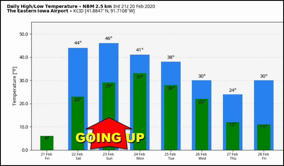
Notice the dramatic change that takes place Friday. Many parts of eastern Iowa will be 20-30 degrees warmer

That gets highs into the upper 20s in the snow covered north to the mid 30s south.

The warmest day looks to be Sunday when highs could be as much as 10 degrees above normal in my southern counties. These are the projected anomalies for Sunday on the GFS.

Sunday night is when things start to turn sour as cooler air and a complex upper air pattern brings headaches to the forecast in the form of 2 separate systems. Right off the bat phasing again rears its ugly head. When I talk about phasing its how energy in the northern and southern streams interact. Split flows mean no phasing and little cold air. Full mergers can get you big intense precipitation producers. Then there's everything in between where there is some interaction and influence of each stream but with varying amounts of impact.
For reasons I won't get into, this winter the entrance region of the jet into the Pacific Northwest is in just the right place that energy diving into it goes into the southwest. There it waits for a kicker to send it east across the country. This is where models have to decide if the two streams merge of go separate ways. What happens at this point can mean the difference between a sunny day or one with 8" of snow...or something in between.
Phasing is a known challenge for models to resolve but this year the process seems to be particularly daunting producing solutions that seem to go back and forth right up to the very end. It's extremely frustrating as a forecaster as the ups and downs and lack of consistency make it mighty tough to get a read on what's going on.
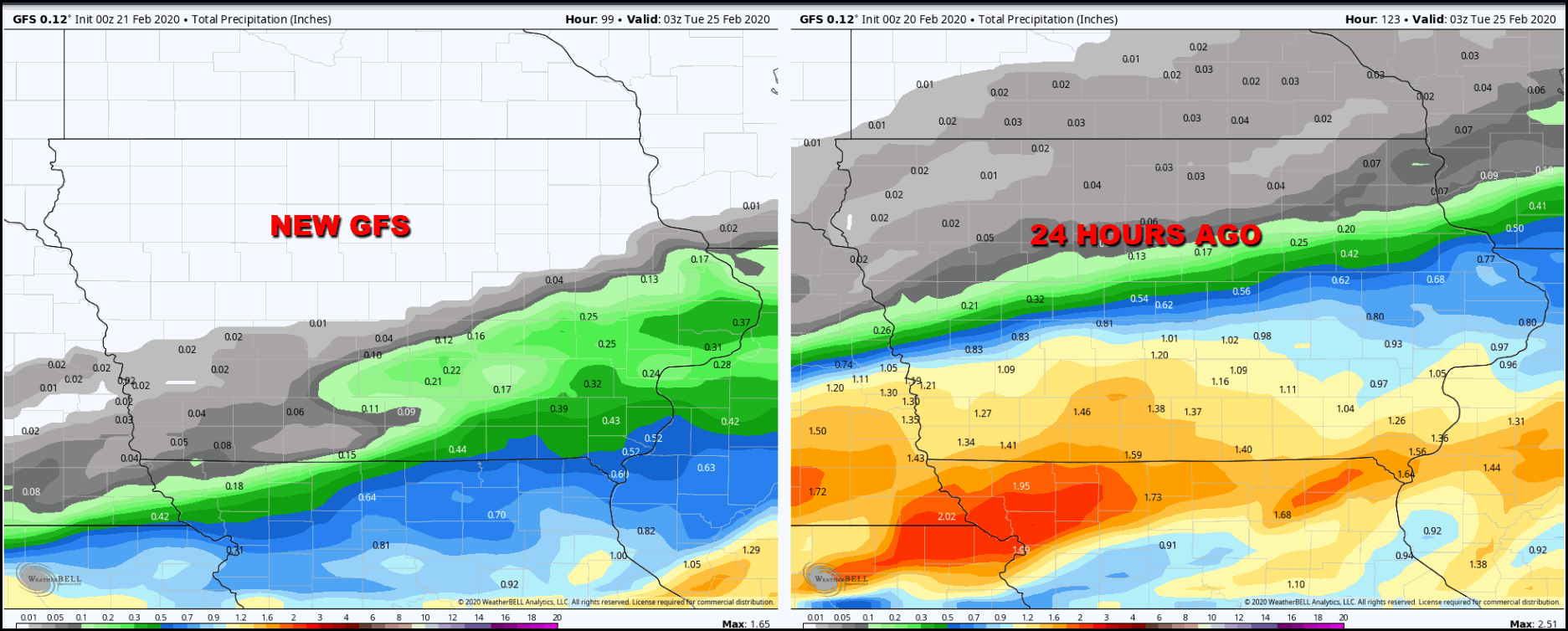
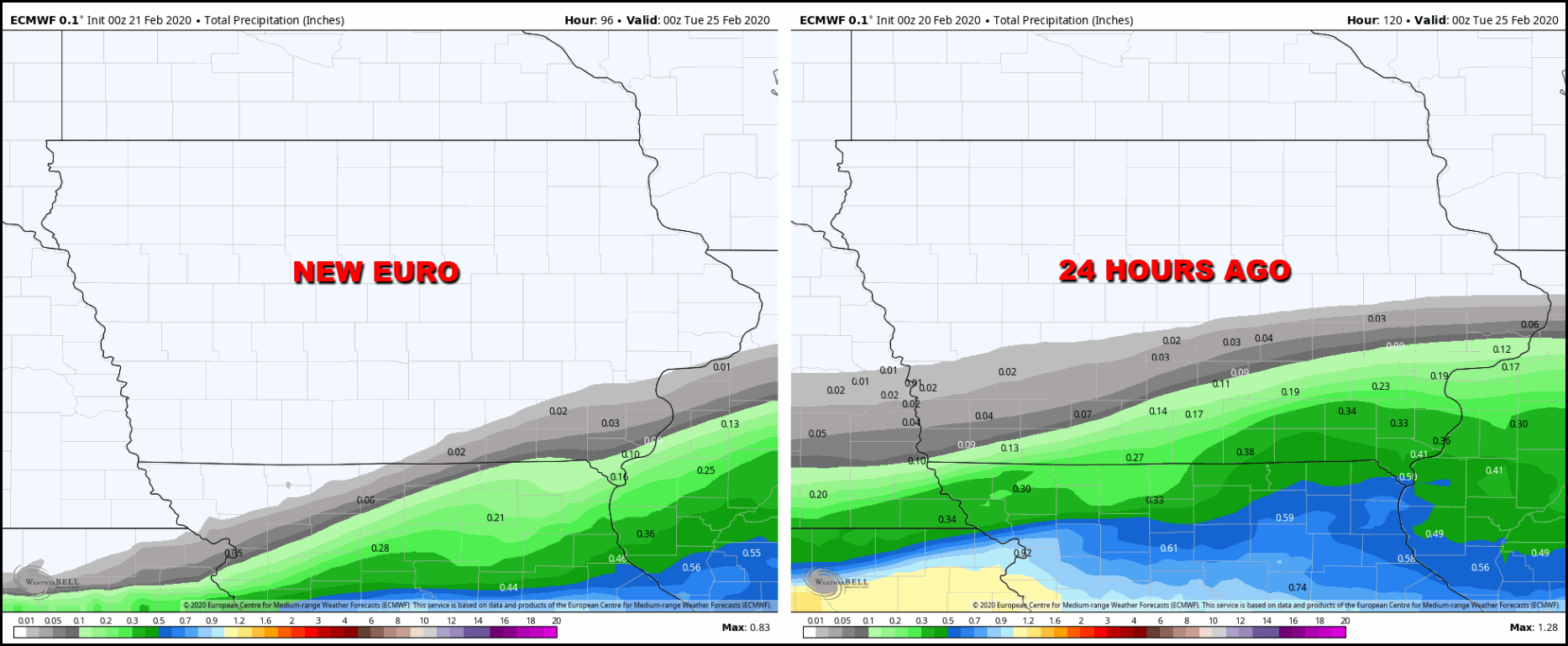
That leads me into the first system Sunday night and Monday. Two days ago models were in agreement the precipitation shield would stay south of the area, Yesterday, more phasing had it well into Iowa. Today. less phasing has pushed it back south. The EURO really buries it and keeps things dry all the way to the Missouri border. The GFS gets precipitation up to I-80. For comparison purposes, here's the 24 hour precipitation changes in the 2 models for the period Sunday night and Monday.
The GFS, Wednesday night (24 hours ago) it had the half inch precipitation line close to HWY 20. Thursday night that's down near the Iowa Missouri border
The EURO. Wednesday night (24 hours ago) the half inch precipitation line just clipped the southeast tip of Iowa.Thursday night it's closer to St. Louis.
So, that leaves me with the question, keep things high and dry like the EURO Sunday night Monday or go with some rain or mixed rain and snow in my southern counties like the GFS shows? If you took in my post yesterday you dang well know the sword I fall on is the EURO. I suspect its drier solution is correct for system number one so I will throw out the GFS and go dry Sunday night and Monday like the EURO depicts. I will also cross my fingers no last minute phasing pulls the whole thing north again. I really don't think that's likely now.
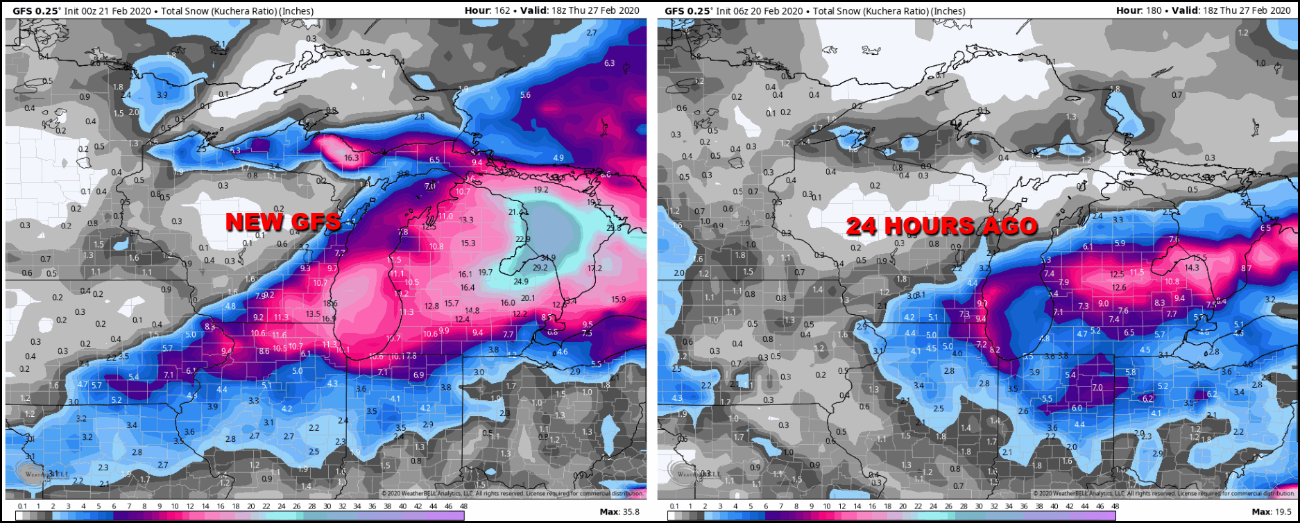
That brings me to the second system and that is where some part of the Midwest has the potential to see snow Tuesday night and parts of Wednesday. That's tied to a deepening 500mb upper air low that closes off over Missouri and heads for southern Illinois and Indiana. It's far too early to get caught up in numbers but Thursday night's runs do show some decent accumulations that in spots are up around 4-6 inches. However, you can see there has been a lot of movement over the past 24 hours and the EURO is further south and east than the GFS. That's a big deal for my area as it would keep the more significant accumulations from the Mississippi River on east. The GFS would have them well back into the SE third of Iowa.
The GFS
The EURO

I'm not sure either model has a handle on the trends just yet but it does appear Tuesday night and Wednesday is the next time frame to watch for weather issues in my area. I would say confidence is at least moderate that there will be some snow in the central Midwest but it's low with regards to amounts and location. Time is needed to get a grip in this part of the long range forecast. At least we have the luxury of that. Roll weather...TS
PLEASE JOIN US FOR WEATHER SCHOOL, SEVERE WEATHER 101:

We have a brand new weather school planned for April 4th. This one is called Severe Storms 101. If you want to know more about the ins and outs of severe thunderstorms and how to forecast them this will be a great introductory session. There will be event simulations and a big focus on tornadoes. Some tips on chasing them as well. Aside from that there will be in depth focus on the 1968 EF5 Charles City tornado outbreak, the Parkersburg EF5 of 2008, and the rare mid-November EF4 Washington, Illinois twister that occurred November 17, 2013. Lots of compelling video and insights presented by 3 meteorologists. Contact Carolynswettstone@yahoo.com to sign up or click on the more details button in the graphic above to find out more!
Thanks


