WHAT GOES UP...
- terryswails1
- Mar 12, 2020
- 3 min read
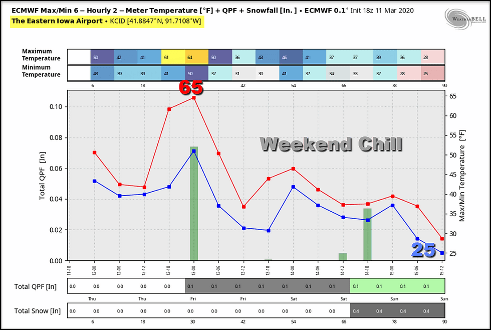
The next few 48 hours my area will be on the temperature roller coaster spring is noted for here in the Midwest. You can see it in the meteogram the EURO lays out here in Cedar Rapids through Sunday.

Here's another way of looking at the same data. In 3 days we drop 40 degrees from a high of 65 Thursday to a low of 25 Sunday. Thump!

Needless to say you will want to enjoy Thursday's warmth, but it won't be a flawless day. The cold front that brings the change will also bring the threat of some showers. These could start late morning in my NW counties and then spread to the Mississippi River by evening. Overall, amounts should be light 1/10th of an inch or less. On the surface map below you can see the showers advancing out of eastern Iowa into Illinois at 6:00pm Thursday.
After the front passes much cooler air starts to enter the pattern just in time for the weekend. While it won't be that noticeable where we are Friday with highs upper 40s to low 50s, the air aloft at 5,000 ft. will be much colder. In fact, it's so cold at that level by Saturday that any precipitation that falls would come in the form of snow. That is where the forecast becomes challenging for me and my southern counties.
The issue is whether a band of snow that develops in Missouri will reach my southern counties as snow? If it does, how far north does it spread? If you look as the surface map mid-day Friday you will see high pressure building into the Midwest. That's responsible for the colder air

It's also tapping into dry Canadian air. The graphic below represents the amount of water vapor available for precipitation. It's bone dry at only 10 percent of normal.

So Saturday as a 500mb short wave crosses the Midwest, the concern for my area becomes (especially south of I-80), how strong is that dry air and does it eat away at the moisture that would otherwise fall as snow. It will no doubt create a sharp gradient to the northern edge of the snow band. In other words, a very hard edge to who's in and who's out of the snow. That line currently appears to be somewhere close to HWY 34 running through southern Iowa and WC Illinois.
Something else that's very relevant is that models often struggle with this issue of dry air. They tend to push the snow too far into it during the early stages of development...like we are in now. I have serious concerns that they are too far north with the snow and associated accumulations into my southern counties. To off-set that issue, the short wave would have to be stronger than what models currently show. There's no way for me to know some of these factors just yet but they could certainly alter the forecast with regards to where snow falls, if it does at all. My confidence is still lower than average and all I can do is wait for more data to confirm my suspicions of a more southerly track that bypasses my southern counties..
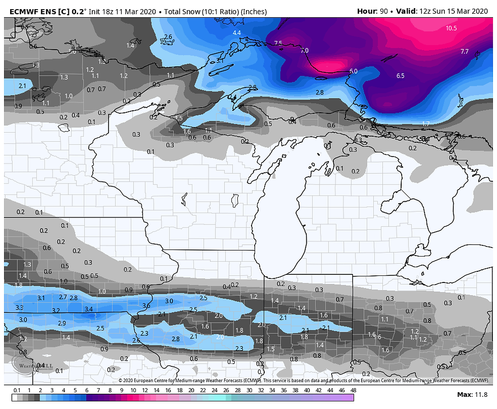
As things stand now, we still have 48-64 hours before the event and changes of some magnitude are likely. With that, these are the model snow forecasts available to use as guidance.
The EURO

The GFS

The 12K NAM

We should have a better feel for trends later Thursday. Meantime, most of my area will enjoy a decent day until the showers arrive later in the afternoon. Have a fine day and roll weather...TS
WOULD LOVE TO HAVE YOU FOR WEATHER SCHOOL..
There's still space available for about 25 people in our newest addition of weather school. We've put a lot of work into developing interesting and educational content with the goal of teaching you how to foresee and forecast severe weather. The small size of the class will allow a very personal and interactive experience. This will be a fantastic chance to see and learn about the most violent storms on earth. It's a robust session with interactive simulations and heart thumping videos! Click on the banner below for more details or, email the fabulous Carolynswettstone@yahoo.com to grab a spot. Would love to have you as our guest.


Comments