


TIME TO PAY THE PIPER...
We enjoyed a a mild winter here in the Midwest but now (when we least want it) it's about time to pay the piper. Following a springlike day Tuesday a significant pattern change arrives in the form of a late afternoon cold front.that should mean at least 2 weeks of below normal temperatures.
The Weather Prediction Center has a moderate to high risk of hazardous temperatures in the April 14 to 16th time frame.

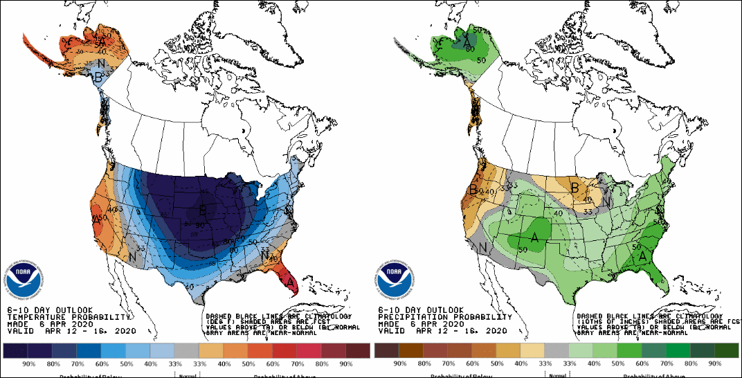
There's a greater than 70 percent chance of below normal readings April 11-17th.
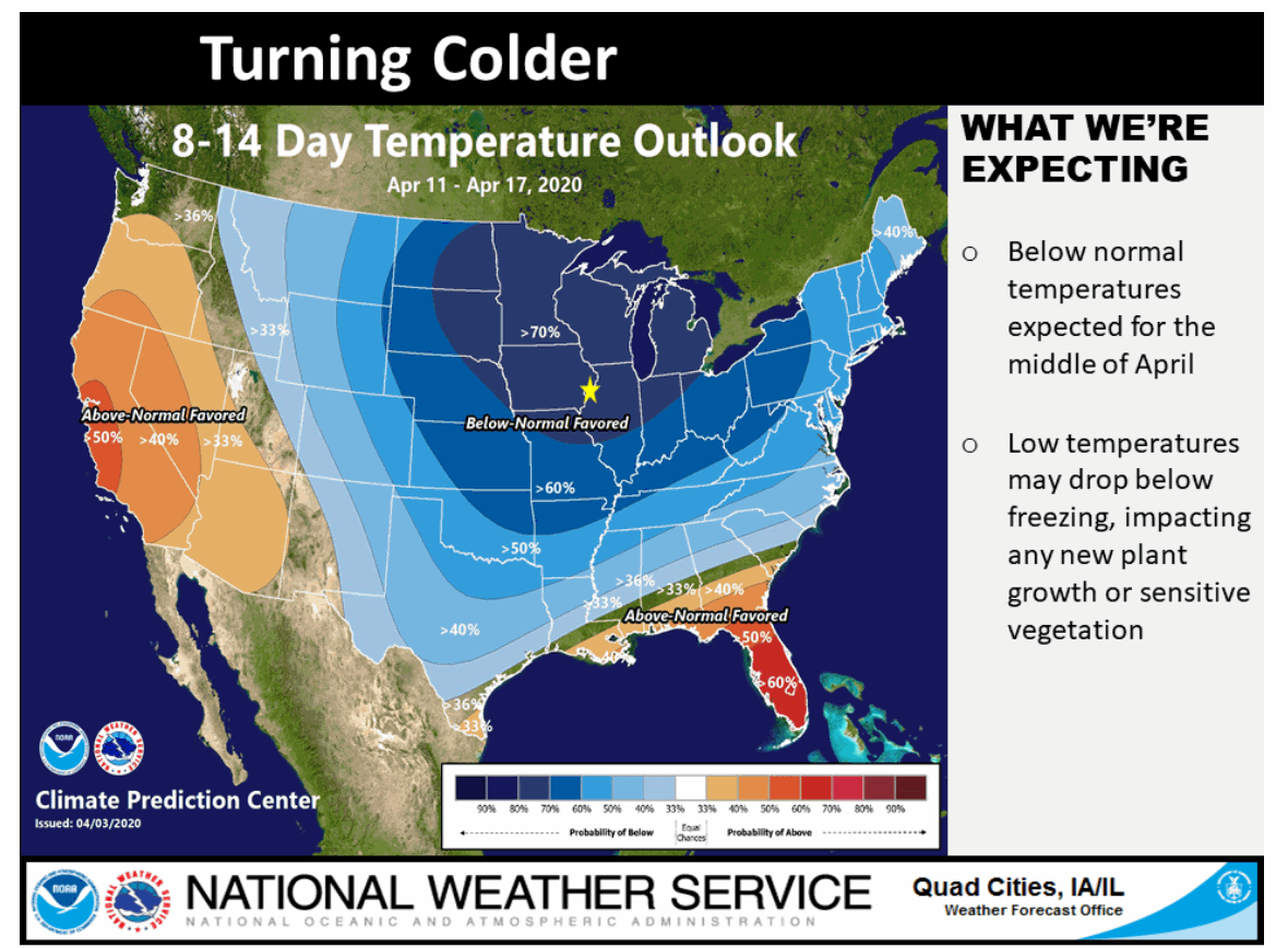
During the period April 12-16th the odds are 80-90 percent of below normal temperatures over the entire north central United States!
You can see we have a day of warmth to enjoy Tuesday when highs should reach 74-80 from north to south in my area. That's a good 25-28 degrees above what's typical. There is a chance of a late day or evening shower or thunderstorm, mainly southeast of a line from Cedar Rapids to Dubuque and on to Madison. There is a bit of a cap to overcome but if things time out right there is enough instability for a few strong storms. A wild card to watch. Some models show it, others nothing at all.

Anyway, that breaks the ice for colder air to start entering the Midwest. By the 14th the storm track has morphed into this and down comes the cold air that's been lurking in Canada. There's a strong connection to the Arctic in that type of pattern.

That leads to temperature departures in some parts of the Plains that are 50 degrees below normal. Locally we're looking at a few that could get more than 30 degrees below average by April 15th.

One other issue to deal with is the potential that a part of the Midwest could see late season snow. I mentioned this possibility last week and indicated my confidence was growing that some areas of the central Midwest would see some flakes I also noted it was impossible to tell this early where that would be or even how much would fall. But, based on the amount of cold air on the table and the added moisture and dynamics of April, it could make for an impressive set-up with a decent band of wet snow.
What a strong storm in this type of environment will come down to is phasing. If (and right now it is far from a sure thing) the northern and southern branches of the jet can merge into one, there is a high likelihood of a significant storm spinning up. I'm going to show you what the worst case scenario would look like but this is just for meteorological and educational purposes. This is what the 12z EURO developed Monday and for all practical purposes it is a superstorm! Is it possible? Probably not. Every conceivable factor would have to come together just right which is a huge undertaking.
However, I will say in defense of the EURO, there is record warm water in the Gulf of Mexico that is loaded with latent heat. There is also what appears to be record cold air digging into the central U.S. If the interaction between the two were to take place in the proper way, rapid and deep cyclogenesis could result. However, without full phasing that scenario will never be realized and we have a far weaker solution with much less impact.
So, just for the purpose of showing you what is the worst case solution is (one that I very much doubt will come to full fruition), I show you the EURO 12z superstorm. Nothing more than eye candy and a trip into fantasy land for a single model run. In my world this is as good as it gets and a set-up that you rarely see. So, enjoy it for what it's worth, it's a near certainty it's gone on Tuesday's 12Z runs.
Here's the surface low the night of April 14th. It's bombing out in WC Indiana at 977mb. Powerful winds and heavy snow are falling to the northwest.

When I say powerful winds I mean gusts of 70-85 mph in the Great Lakes. Everybody in the Midwest seeing winds of 50 mph or greater.

By Wednesday at mid-day the storm has deepened to 962mb which is 28.39". That is a beast!

Look what the storm is shown producing with regards to snow. A swath in Missouri through Illinois and Michigan racks up 20-38". Toss in those winds and the heavy wet nature of the snow and this would be one for the April record books. However, the chances of this ever happening are slim and none so everybody take a deep breath. Something like this happens maybe once every 75 years and I doubt this is that time.

In fact, if this wasn't the EURO I wouldn't even put this up. The GFS comes up with junk like this all the time and I just laugh it off. Being the EURO, I laughed but not nearly as hard or long. As a forecaster I just have to think, what if this was the time it actually happened. Then I pinch myself and say, no way, time to wake up from that beautiful dream!
Okay, that's all I have for now. Tuesday I'm sure we can chalk this up to a case of model indigestion and we can put this whole scenario behind us. However. It sure was fun to look at in fantasy form. I just don't see charts like that very often, especially on the EURO (be it right or wrong). No matter what happens with any sort of snow threat, it is going to get cold by April standards and spring is going to take an extended break. Roll weather and enjoy today's relative warmth...TS


