


HAIL YES!...
After an absolutely beautiful afternoon and highs in the upper 70s to near 80, conditions became conducive for severe hail along a southward advancing cold front Tuesday evening. Storms rapidly developed and it just so happens that I was in the right place for some of the bigger stones. Here in Marion, Iowa and parts of NE Cedar Rapids, golf ball sized hail (with some stones as big as tennis balls) broke some car windows and damaged the body of many others. In my neighborhood there was all kinds of excitement following the show as kids shrieked with amazement as they ran through yards collecting the biggest chunks of ice which they loaded into buckets.
This is my dog Nimbus curiously inspecting a golf ball sized hailstone.

Here's an image taken by the Iowa Storm Chasing Network of tennis ball sized hail near Cedar Rapids.

This shot was sent to me by meteorologist Nick Stewart of stones that damaged numerous cars at KGAN TV, my old station.

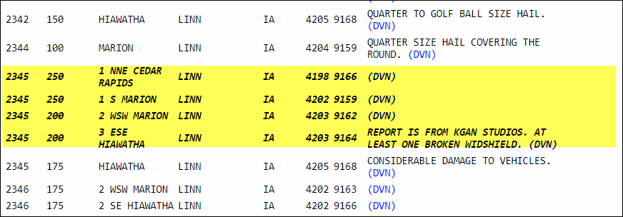
East central Iowa and northern Illinois were at the epicenter of the hail storms. Just before 9:30 Tuesday evening SPC indicated 187 hail reports with 19 of large hail (2" diameter or greater).

Below you can see the 2.5" diameter reports around my place in Marion. It was sweet to watch.
A much stronger cold front will arrives Wednesday afternoon and once again mild air will be in place at the surface. By afternoon, temperatures in the lower to mid 70s will combine with the front and dew points in the upper 40s to mid 50s. This combination will provided high clouds bases for any storms but like Tuesday, deep layer shear and steep mid level lapse rates will bring a threat for organized cells. With a stronger cold front Wednesday, a more widespread coverage is likely in the afternoon and early evening hours, especially over the southeast half of my area. With high clouds bases, any tornado threat is low, but a deeply mixed inverted-V should support momentum transfer into the downdrafts and this could support a wind threat. Any storms are likely to organize an outflow boundary and quickly form into a line, exiting the area early Wednesday evening.
Then the winds increase and the temperatures decrease as the Midwest enters into one of the coldest final 3 weeks of April in the past 2-3 decades. Just one look at the projected 500mb pattern on the EURO April 14th tells you all you need to know. A big west coast ridge and a central U.S. trough mean well below normal temperatures.

Some of the coldest readings are projected around the 15th when much of the Midwest is looking at temperature departures of 20-25 below average.

Here's the day 5-10 departures April 12-17th

Now April 17th-22nd.

With so much cold around the potential is there for some of the precipitation that falls to come in the form of snow. As expected the EURO has phased energy differently than Monday and taken the superstorm it showed out of the picture. Even so, the operational EURO has plenty of snow its just further NW.

The GFS is further south impacting parts of my area with significant snow. Again, I would put more much more faith in the EURO solution than the GFS. But, their is more chaos in the pattern than usual so I think we need more time to see this through.

Again, I would not read anything into snow forecasts until we can get the cold air in place later this week and get a better handle on its depth and where short waves are likely to track. I still believe we have not seen the last of this seasons snowflakes and I would not be a bit surprised if some part of the central Midwest experienced a significant wet snow before we get this pattern turned around late April. At least for now, I don't see any snow issues locally through the rest of the week. Roll weather...TS


