


WINTER IS FAR FROM OVER...
Late Wednesday afternoon we turned the switch on for a much cold weather pattern for much the remainder of April. As of 7:00 pm temperatures over all of my area were running 20-30 degrees cooler than 24 hours earlier!

With the arrival of the colder air storms again developed in parts of my area Wednesday afternoon. As they departed weather photographer Paul Brooks to this beautiful shot in Cedar County, Iowa.

There were again some reports of severe weather in southeast Iowa and WC Illinois where 1.75" hail far near Macomb in Mcdonough, County Illinois.
The Storm Prediction Center through late Wednesday indicated another 325 reports of severe weather. mainly hail and wind.
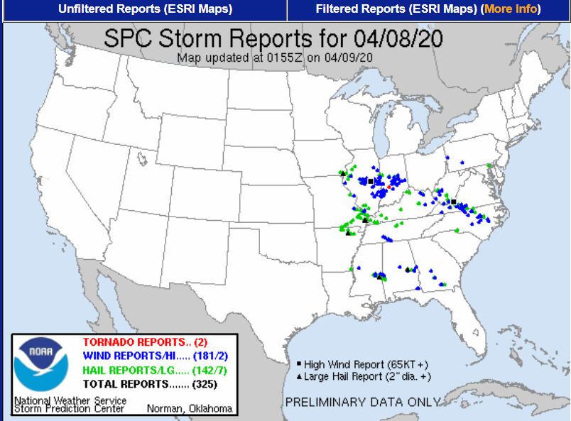
Compare that to what was found Monday.

Around here the threat of severe thunderstorms appears minimal for some time as the colder pattern driven by this upper air configuration gets established.

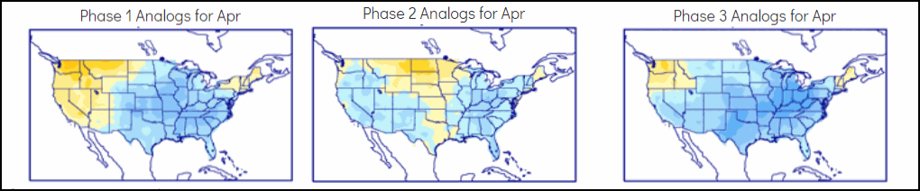
This is in keeping with the MJO (Madden Julien Oscillation) which is set to cycle through phases 1,2, and 3 over the next 2 weeks. Follow the dotted green lines for the daily advancement through the 22nd.

That's the holy grail of cold when it comes to April. Here's the phase correlation of phases 1, 2, and 3 in April.
Here's what the temperature departures look like over the next 15 days in 5 day increments.
Day 0-5

Day 5-10

Day 10-15

With all the late season cold air in place the models are suggesting snow for many parts of Midwest with a significant late season event possible late this weekend and Monday. Models have exhibited a great deal of uncertainty the past few days as to the location and extent of the system. However, Wednesday night's guidance has come into better agreement showing more consistency and an important shift south in the placement of the snow. This is still far from certain but the odds are increasing that northern parts of my area could see a heavy wet snow, especially northwest of a line from near Ottumwa to Cedar Rapids and on to Dubuque and Madison. Here's the latest snowfall forecasts.
The EURO

A closer view of the EURO.

The GFS

Ahead of the snow another disturbance will bring some rain to my area Saturday afternoon which exits by Sunday morning. Then the next wave arrives late Sunday afternoon with rain or (snow in the NW) that continues into Monday morning. Some significant precipitation amounts are likely with the 2 events that could exceed an inch over my entire area. The EURO has this for totals.

Whatever happens we are entering into an ugly period of weather devoid of any spring warmth for the next 7-10 days, or beyond Hope you enjoyed the mild conditions of the past few days! Winter is far from over. Roll weather...TS


