


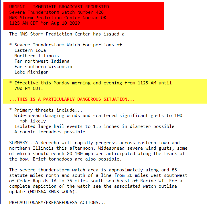
PDS WATCH IN EFFECT...PARTICULARLY DANGEROUS SITUATION
A PDS Thunderstorm Watch has been issued for most of my area until 7:00pm. PDS stands for particularly dangerous situation, primarily for straight line winds that have the potential to reach 80-100 mph.

The watch is in effect until 7:00 pm but with storms racing east at up to 70 mph they will likely cross the Mississippi and be out of my Illinois counties by no later than 5:00 pm

SPC indicates a greater than 95 percent chance of at least 6 events of severe wind. Odds are at 90 percent for more than 10 severe wind events along with a 90 percent chance of at least one 80 mph gust.

The actual PDS watch and discussion.
As you can see the microburst parameters have focused heavily on my area indicating a high likelihood of strong winds as a bow echo races east. Damage and winds to 90 mph have been reported.

Here is the radar showing the intense bow echo on NWS Doppler entering my western counties. If you have things outdoors that will blow around get them in or secure asap. Bow echoes area also know to produce quick tornado spin ups. This is a legitimate threat that should be taken seriously. Atkins, Iowa in Benton County just reported a 90 mph gust! Roll weather...TS


