


THE CALM AFTER THE WIND STORM OF A LIFETIME...
- Aug 12, 2020
- 3 min read
Let me start this blog by saying how sorry I am for the hundreds of you back in the Midwest who lost so much in Monday's massive storm. The extensive trail of destruction is beyond belief and staggering in overall scale. Iowa's Governor Kim Reynolds says a third of the states' corn crop, (10 million acres) was damaged by the long tracked derecho. That is a mind boggling figure. Damaged crops can be seen in this hi-resolution GOES satellite imagery shot Tuesday.

Among what was destroyed or impacted: trees, crops, power lines, homes, farm buildings, health care facilities, semi-trucks and some transportation routes like highways. Parts of Interstate 35 and 380 and highways 18 and 69 were impassable, parts of which were closed entirely."Although it will take days and weeks to know the full scope of the damage, initial reports are significant," Reynolds said. Without question this will be one of the most destructive storms in Iowa history. Some preliminary damage estimates have already come in at $10 billion dollars.
For some more perspective, just look at the percent of people without power in Iowa 24 hours after the storm. Incredibly, entire counties were left in the dark. 97 percent of Linn, Tama, and Marshall counties were without power Tuesday morning with many more counties in Iowa and Illinois in similar but less extreme positions. In my long weather career, I cannot remember such astounding figures over such a large area, and that includes a couple devastating ice storms.

Below you can see the core of the worst damage running on a southeast line from Sioux City to Cedar Rapids and on to the Quad Cities.

This next image shows the timestamp of the derecho as it barreled across the Midwest. At the apex of the derecho (near the comma head) wind gusts of 80-112 mph occurred.

This is a video that gives you some real insight to the power of the storm. It was shot by my friend and KGAN meteorologist Nick Stewart. At about the 3 minute mark the window in his vehicle blows out. Technically we don't have hurricanes in Iowa but if we did this is what they would look like. Thanks Nick, what a ride that was.
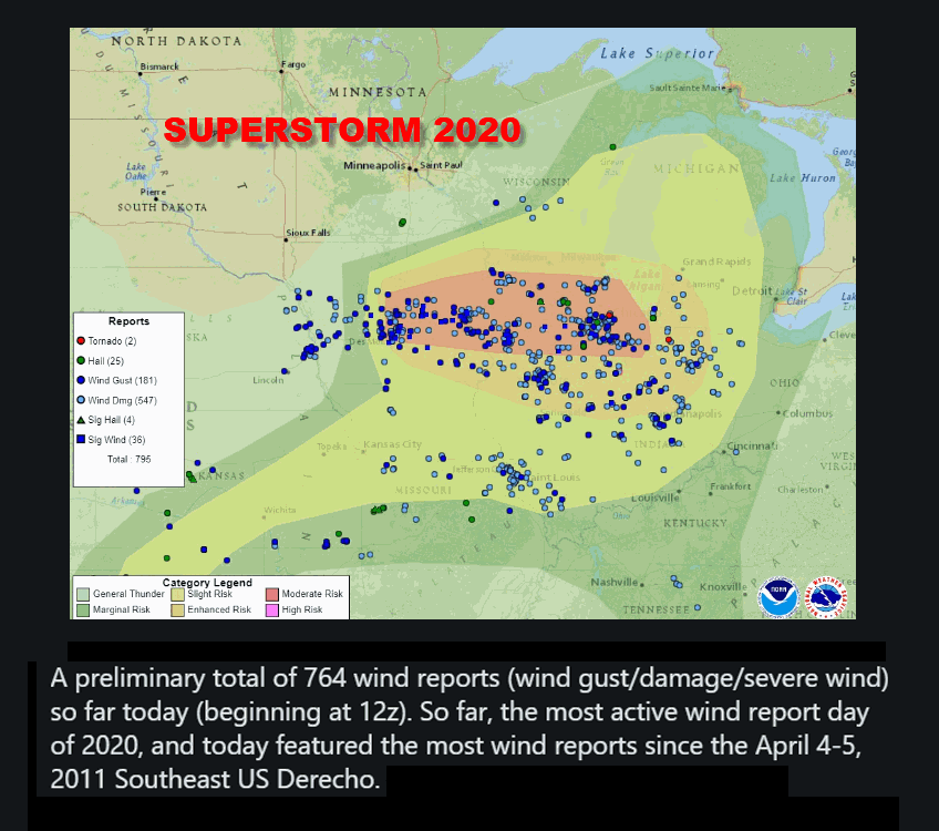
The 764 wind reports Monday make this the most active wind report day of the year for severe weather. Additionally, this becomes the most wind reports since a derecho slammed the southeast April 4-5 2011.
On this Doppler velocity scan a wind gust of 141 mph is indicated east of Mt Vernon, Iowa near Mechanicsville. Due to the distance from the radar site and the curvature of the earth this was not at ground level but up in the structure of the derecho. However, it's some of this momentum that was transferred to the surface unleashing gusts of 90-100 mph at the deck. Doppler is such an incredible meteorological tool.

Again, it pains me to see so many people negatively impacted. I'm especially dismayed for all of our hard working farmers whose margins are already slim. Every farmer knows from year to year the weather can break you. It's the great intangible you can't plan for. I'm just hoping that the spirit of our farming men and women remains strong and your faith and love for the land can get you through this difficult year. Bless you all and know that our thoughts are with you. ANF!
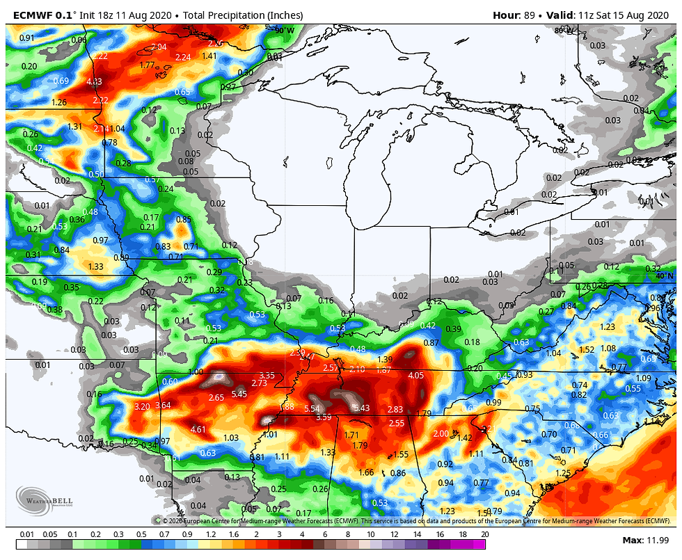
Regarding what's ahead with our weather, I would have to say not much for the next week or so. The EURO has this for rainfall through Saturday morning indicating dry conditions for much of my immediate area and points east..
Temperatures the next few days look seasonal with highs in that 80-85 degree range. The EURO has this in Cedar Rapids the next 4 days.

Going a step further, the 6-10 day outlook promises some great weather if you don't need rain. Pleasantly cool and dry sums it up.At least it's good for the long clean up ahead.

That's all I have for you this time around. Stay strong and positive everyone! Roll weather...TS


Comments