


SOMETHING TO LOOK FORWARD TO...
The weather around the central Midwest is taking on a decidedly quiet look the next couple of weeks. That means comfortable temperatures along with well below normal precipitation. To get the combination in mid-late August you certainly need an upper air pattern that has a northwesterly component limiting moisture and warm air. We do see that on the GFS next Monday.

The ensuing temperature departures look like this in 5 day increments.
Days 0-5 ending August 17th

Days 5-10 ending August 22nd

The GFS meteorgram the next 12 days. I like that party!

Here's the precipitation departures which are also significant in terms of the dryness indicated over the next 10 days throughout the central Midwest.

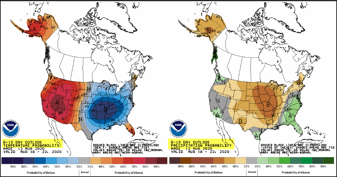
The Climate Prediction Center is on the bandwagon showing the trend of pleasantly cool temperatures and dry conditions. Take a look.
The 6-10 day temperature and precipitation outlook August 16-22.
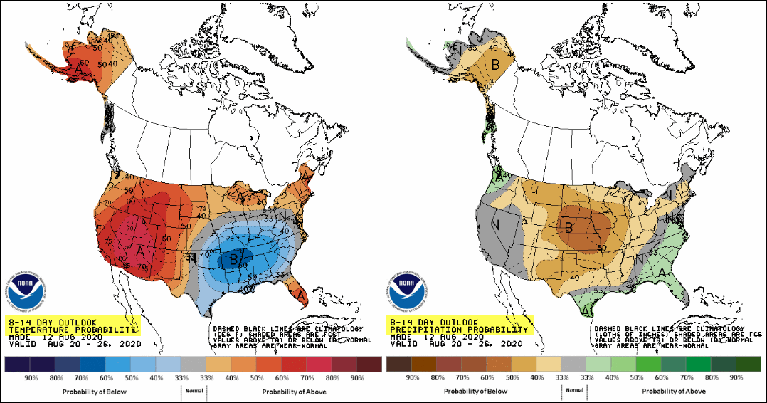
The 8-14 day temperature and precipitation outlook August 20-26.
While we'll all enjoy the mild temperatures many areas could still use some rain meaning the lack of it is not necessarily good news. Here's the 30 day deficits as a percentage of the mean. Much of my area, especially in Iowa has seen just 25-50 percent of its average rainfall.

Prospects for anything beneficial are not very bright with the EURO showing this for 10 day rainfall totals.

By the way, clean up continues from Monday's derecho. 33 percent of Iowa's corn crop has been significantly damaged or destroyed. Damages to the 10 million acres involved is currently estimated at close to 3.4 billion dollars. That's just corn, the figure does not include all the trees, power lines, structures, and vehicles that sustained heavy losses. This picture was retweeted by the NWS in the Quad Cities. It was initially sent by my friend and KGAN meteorologist Nick Stewart. It shows a before and after image of Cedar Rapids along Collins Road NE. Notice the difference in the amount of tree foliage. What a devastating storm.

Again, the bright spot in the aftermath of the storm has been cooler and much quieter weather. Readings will warm a bit the next couple of days but in essence should be close to seasonal norms around 83-87 degrees. There is a slight chance of a shower Thursday morning in the north and in most areas again Saturday. However, these look to be scattered and light. Best chances seem to be near and north of HWY 20 near Waterloo where a few spots could see up to 1/3 of an inch. In general, amounts of that magnitude are going to be the exception as opposed to the rule. Most spots that see rain will be lucky to pick up 1/10 of an inch. The majority of my area south of HWY 20 is currently in line for little if any rain through Saturday.
That is all I have for now. Until next time, roll weather...TS


