SEPTEMBER'S VARIED SONG...
- terryswails1
- Sep 2, 2020
- 2 min read
A new month has arrived and weather changes are coming with it. We've already noted that with some rain falling in parts of the area Tuesday. Unfortunately coverage was spotty and confined mainly to the far southeast. Models did not do a great job of depicting amounts or placement. The EURO was especially overdone which is unusual for it within 24 hours of an event. It showed this for rainfall Monday night for the period ending Tuesday night.

In reality, these are the Doppler estimates from the NWS radar in the Quad Cities Tuesday night. There were some good amounts in Missouri and Illinois but they only grazed my southeastern counties. Not one of the EURO's better efforts. I was in its camp and expected more than what we got. So much for putting the hex on the saying, in times of drought signs of precipitation don't pan out. The drought won this round in my area.

Now that this wave has departed it looks like the rest of the week will be quiet and pleasant. Here's what the EURO shows for highs through Saturday.

The second half of the weekend and next week gets much more interesting. The fun begins with a pair of tropical systems that will effect South Korea and Japan the next few days. They go by the names of Maysak and Haishen.

Here's another perspective of the pair.

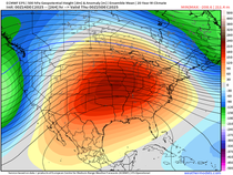
I typically don't focus on this part of the planet but these two entities will move north drawing their energy into the hemispheric wave pattern. They will amplify the global upper air pattern by building a large ridge over the Pacific Northwest. The downstream effect for the Midwest is a major central US trough containing the coldest air in many months. Here is the trough September 9th.

These are the associated temperature departures. The GFS is showing widespread readings of 26-36 degrees below normal.

The GFS also spins up a nice surface low along the edge of the trough that has the potential to bring some soaking rains which would be be very welcome. Before that potential, the arrival of the cooler air could also bring some good rain Saturday night and Sunday. That is worth watching as well.
No doubt about it, September is going to get off to rocking start with a wide variety of weather and temperature extremes. Bring it on. Roll weather...TS


Comments