RAGING WILDFIRES OUT WEST, TROPICAL TROUBLE DOWN SOUTH...
- Sep 13, 2020
- 1 min read
You may have noticed already (or will soon see) the hazy skies in the Midwest. That may linger over the next few days... it's smoke from the wildfires unfortunately raging out in the western U.S.
Here's an image from the National Weather Service in Omaha:

The smoke is caught in the jet stream and is sitting over much of the U.S. right now. Our milky skies are nothing compared to some of the scenes out west.
And check out this statistic from the California Department of Forestry and Fire Protection. Five of the top 20 largest wildfires in the state's history have occurred in 2020:

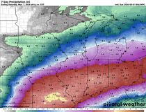
Unfortunately there won't be much precipitation to help the west coast battle these historic wildfires this week. There won't be much precipitation across much of the western and central U.S. this week. There will be a lot of rain -- too much rain -- with Tropical Storm Sally (expected to be a hurricane by Monday afternoon).

Some areas could see more than a FOOT of rain. Storm surge and heavy rain will lead to flooding along the Gulf Coast and in Louisiana, a state still reeling from the effects of Hurricane Laura a few weeks ago.
Sally could be a category two hurricane before making landfall, but the bigger issue is it is moving VERY SLOWLY:

In the Midwest we are getting a break from our deluge of last week and it will be a sunny, quiet week up ahead. Temperatures will generally be in the 70s to low 80s and the next chance for rain doesn't arrive until Friday:

Much quieter here compared to the west and south....
RK


Comments