


NEAR RECORD HEAT SATURDAY...
If you've been following along lately you know we're in for some pretty good temperature swings in the next few days. To give you an idea what's on the table the GFS has us going from a high of 83 Saturday to la low of 32 next Saturday and Sunday. Nothing like a 51 degree swing. (personally I think it could be even greater with Saturday's high closer to the upper 80s.

The EURO is showing a similar situation just not as cold on the lows. The model does have a warm bias at that range and I suspect it will end up colder than 41 by at least 5 degrees. That brings a 50 degree spread into play for it as well.

Here's some noteworthy news. Saturday, the potential exists for some areas to near or even break record highs. Much of my region is shown with 850 temperatures of 24-25 degrees C. That's some of the highest 850s of the year! If we get good mixing and sunshine readings will likely over-respond from what guidance is depicting which is generally mid 80s. These are the EURO 850 temps depicted Saturday afternoon. Impressive by late September standards.

These are the existing high temperature records for Saturday September 26th. Cedar Rapids and Waterloo stand the best chance of breaking records. Burlington is the one station that has virtually no shot at all.
Waterloo 88, 1998
Cedar Rapids 87, 1998
Quad Cities 90, 1891
Dubuque 89, 1891
Burlington 95, 1897
You can see the odds are 90-100 percent on the EURO that highs will exceed 80 degrees Saturday so record or not, it is going to be a very warm day with highs in the top 5 percent of all September 26th days.

Then we get a frontal passage Sunday and we begin the decline that brings temperatures to some fresh levels by the middle of next week. Today models are in less agreement on the evolution and speed of the cold air's arrival. However, in the end both the GFS and EURO come to the same conclusion that breezy and chilly conditions will dominate the pattern by the end of next week. Here's the side by side comparison of the 500mb jet stream flow late next week.

Once we get into that upper level alignment we have entered phase 5 of the MJO (Madden Julien Oscillation). As you can see in the seasonal prediction forecast the MJO locks tightly into phase 5 through October 23rd

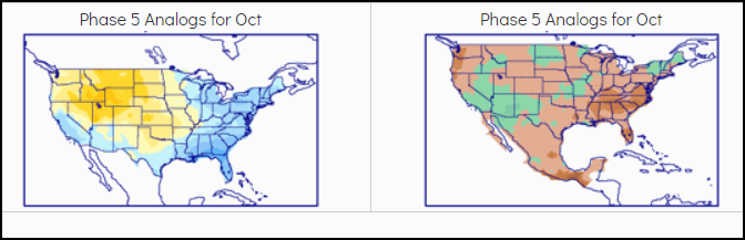
What that implies is that some degree of troughiness remains anchored over the east with a ridge centered over the west. If indeed that trend holds we are in a spot where northwest flow will dominate much of the next 3 weeks. That would imply temperatures close to normal over that period.. However, we may end up getting there with days that are 15 above normal and others 15 below. That's not as extreme as what's coming the next few days but a more subdued version of that type of push pull pattern is in the offering. It's actually pretty common this time of year. See how the temperature analogs for phase 5 (bottom left below) show the break between above and below normal readings right over my area.
Also regarding temperatures, the precise position of the mean trough will determine how close to normal we are. A slight shift west or east could make an appreciable difference. After the cold in the pattern days 5-10, the day 10-15 day departures show a nice resemblance to the phase 5 October analog above. Note you don't have to go far west to see above normal readings. With time some of that warmth may push east in the days after October 9th as the flow flattens and becomes less amplified.

Then there's precipitation which overall looks meager and that makes sense in a pattern dominated by NW flow and limited moisture. Unless the jet can briefly amplify with a strong short wave, chances for widespread rain appear low over much of the central Midwest. The next chance comes Sunday. The EURO is far more aggressive than the GFS on amounts. We'll see what fresh data bring later today. Meantime, this is the 16 day rainfall departures on the GFS.

Rainfall departures on the EURO out 10 days.

Since today is Friday I say it's only appropriate we end the week with a beautiful day. Your wish is my command. Here's to a sunny mild day and a relaxing weekend. Roll weather...TS


