


A NOVEMBER ZEPHER...
- Nov 18, 2020
- 3 min read
Temperatures struggled to rise Tuesday as the region remained under the impacts of a seasonally cool high pressure. Today it all skedaddles to the east and return flow begins in earnest with a brisk south winds that could exceed 40 mph. These are the 10 meter gusts forecast by the 3k NAM. These are just above the surface so the question is how much of this can mix down to the surface. Even if you adjust 5-10 mph less you still hit gusts of 40 on the low end.

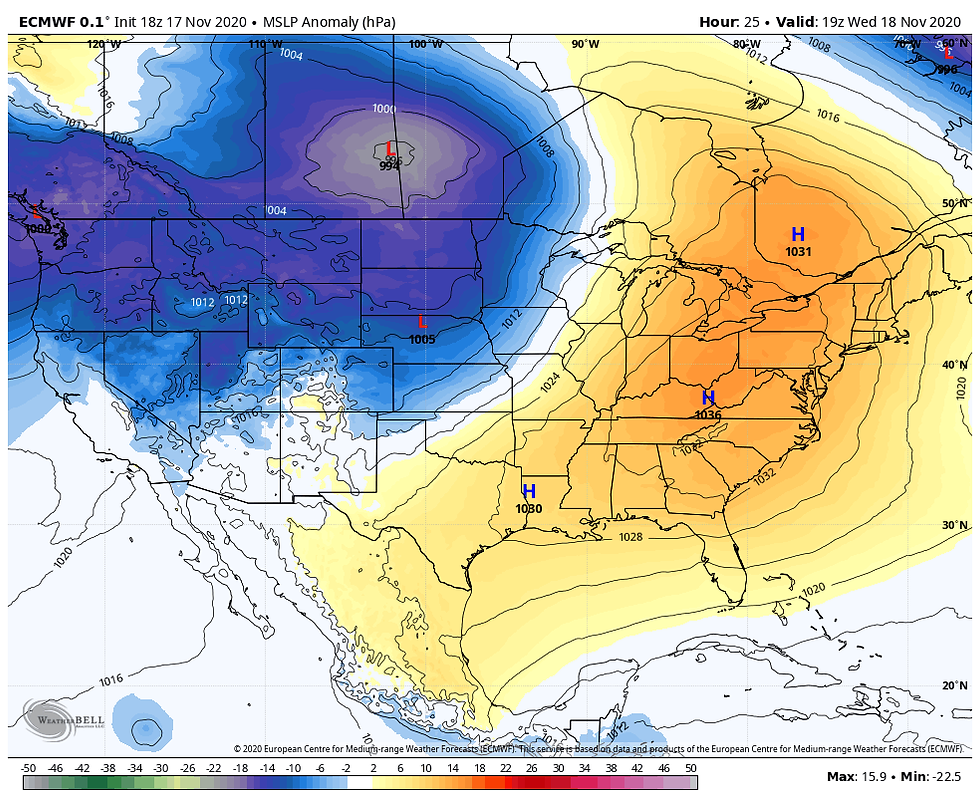
Below you can see the tight gradient between the high to the east and developing low pressure out west. The rapid drop in pressure is the catalyst for todays strong southwest winds at both the surface and aloft.
Temperatures will be at least 10-12 degrees warmer Wednesday but thanks to the brisk winds it will still feel a tad on the chilly side. Thursday the warming builds as the SW wind component remains intact. I look for highs in the mid 60s with a few places, especially near and south of I-80 pushing 70. This is what the EURO is projecting.

As you can see that's about 20-22 degrees above the norms which are in the low to mid 40s.

Eventually a front slips south ending the warmth and bringing precipitation chances back for the start of the weekend. This is where the forecast is less clear and far more challenging. The good news for forecasters is that the GFS has now joined the ranks of the EURO with a cooler push of high pressure. That consistency tightens up where precipitation falls and brings more unity to weekend temperatures.
Starting with temperatures, Friday highs slip to the low to mid 50s with the return of northerly winds. Saturday readings drop another 10 degrees and hold in the low to mid 40s. Come Sunday, we're back in the 30s to near 40.
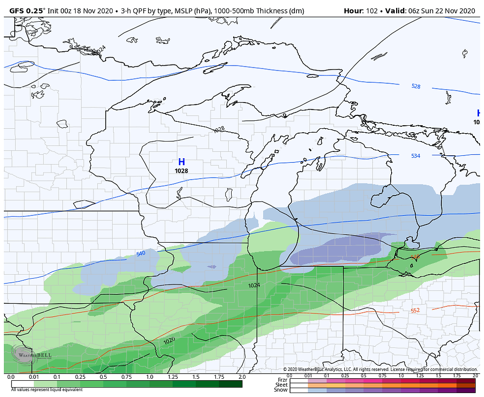
With regards to precipitation, with the front turning stationary in Missouri and southern Illinois Friday night energy will begin to ripple along it. This leads to over-running and the development of clouds on Saturday. Rain that develops in Missouri during the morning attempts to push into my southern counties late Saturday before bucking the high and its dry air to the north. The axis of heavier precipitation has steadily shifted further and further south which each passing model run. The EURO has now eliminated weekend rain entirely from my counties north of HWY 30. The GFS is trending that way but still brings rain as far north as HWY 20. What once looked like a significant precipitation event has now dwindled to one that is light and likely confined to the southern third of my area. Even there it should be light, generally 1/4" or less south of I-80. This is a big change in model guidance.
The GFS has this for total rainfall.

The EURO is even further south and lighter on the totals.

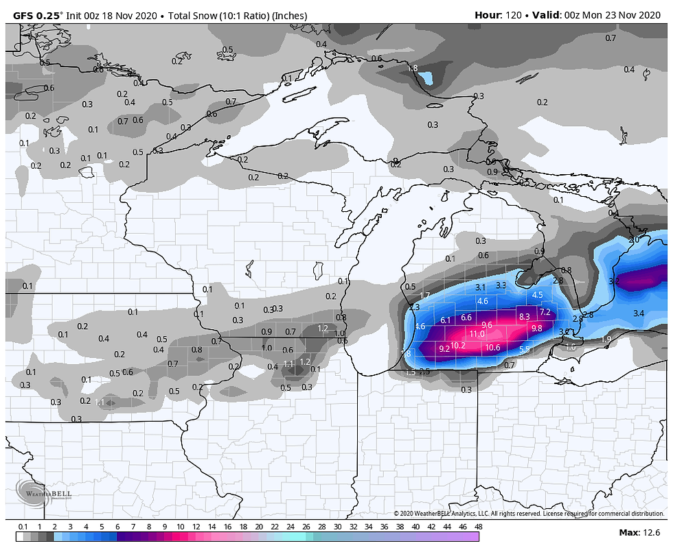
At the tail end of the system the GFS goes so far as to show enough dynamic cooling to change the rain to snow in a narrow swath focused on the central third of my area Saturday night. Here's the surface map at 6:00pm Saturday evening.
Here's what the GFS has for accumulations.
The EURO is less dynamic and does not depict the cooling necessary for any accumulating snow. Again, I think snow (especially accumulating snow) is a very low confidence solution right now with marginal boundary layer temperatures and the warmth preceding the event. I am siding with the snow free EURO and its lower overall precipitation totals based on the evidence I've seen Tuesday night. I think future runs will support my idea and we should be able to confirm my thoughts in my next post. Roll weather...TS
Before I go, here's a graphic on derecho climatology in the United States. As you can see, these types of storms are a summertime phenomena with the peak months of occurrence being June and July, following the peak of tornado season.

In my new book Derecho 911, Iowa's Inland Hurricane, I take a comprehensive look at past derechos and examine the climatology of when and why they form. I also include research that shows there is a part of Iowa that has been especially vulnerable to high end derechos over the past 3 decades. You'll learn why these storms are harder to predict than tornadoes and hurricanes and why they can be just as damaging and deadly. Our special pre-sales promotion continues. For more information or to get your copy click on the link below. Thanks much and ride low...TS!


Comments