


DOING THE LONG RANGE RAIN DANCE...
- Jun 15, 2021
- 3 min read
I think it's an established fact that outside of some small pockets, most of my area and points west have been on the short end of the rain stick this month. Here's the totals through June 14th.

Those amounts are 2 to 35 percent of the accumulated mean for the period. Time to do the old rain dance!

Not only has it been dry, it's been very warm with some of my northern counties close to 9 degrees above normal for the month so far. Minnesota has been especially toasty with departures up to 13 degrees..

The combination of warmth and dryness is taking a toll on crops and pastures making it critical that parts of the central Midwest get needed rains in the next couple of weeks.
Observing the projected pattern, I'm seeing things that bring me optimism regarding the potential for a wetter pattern. Lets start with the EPO (eastern Pacific oscillation). This teleconnection in a negative phase strongly signals a trough over the eastern and central United States. Below are the 2 latest EPO projections off the EURO ensembles. The mean (dotted green line) dips to -4 on both runs. That's a strong negative EPO. The control on the 0Z run (black line in the bottom graph) actually went off the grid by 7 standard deviations. Holy cow!

The 0Z run with its control value at -7 is unworldly.

What this suggests to me is that a strong baroclinic boundary is likely to set up on the southern edge of the jet, a spot where lift is enhanced and precipitation likes to form. Here's an example of the pattern at 500mb next Monday on the EURO.
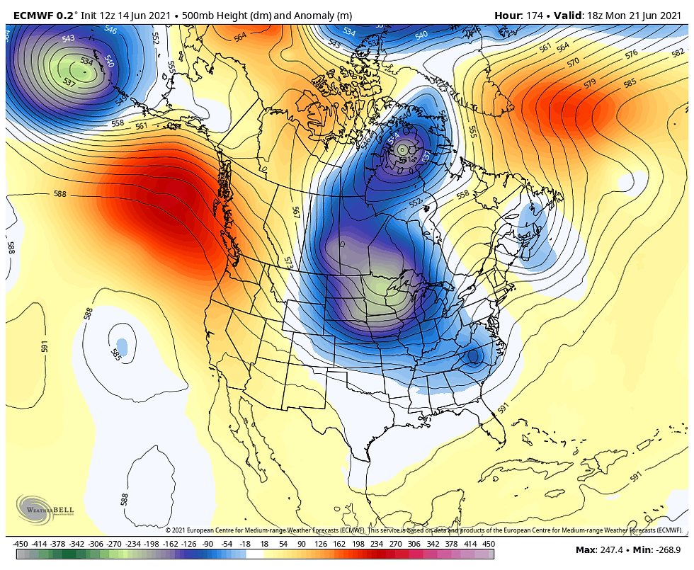
Note temperatures near 100 in Missouri lowering to the 50s in northern Minnesota. The baroclinic boundary is where the contrasting air masses converge along the northern edge of the heat, a spot known as the ring of fire.

The ring of fire has a reputation for producing thunderstorm complexes known MCS's (mesoscale convective complexes) that can generate severe weather and heavy rain. In June and July these can become big players generating much of the rainfall that occurs during those months.
At this distance, we can see the ingredients coming together but what we have difficulty projecting where the boundary that triggers the thunderstorms will set up. Lots of variables come into play regarding how far the cool air can push and how long the pattern locks in. If the cool air is too strong, the heavy rains fall in Missouri. If the push is less than expected, it could be near the Minnesota border. MCS generated outflow boundaries can also alter the position of the instability creating even more challenges defining where storms form on any given day.
That said, we usually have a pretty good idea of where the broad scale potential exists for rain and storms and right now the central Midwest is becoming a focus. The first opportunity arrives Thursday night but a more significant potential exists Sunday and parts of next week. This is by no means a slam dunk yet but I think this is one of the better chances for widespread rain during the past 2 months. Whatever happens could prove to be critical for agricultural interests with dry and even drought conditions continuing to expand.
I want to show you some rain numbers and then I will comment below.
Over the next 7 days the GFS shows this for rain...that's a start.

Over a 16 day period it explodes into this with multiple MCS opportunities.

That produces 16 day rainfall departures that look like this. Every part of my area is above normal and some spots as much as 4-5 inches,

First and foremost, the reason I show the numbers is to give you an insight into the potential the pattern is currently holding. However, potential is not reality and no model is going to give you accurate placement and amounts this far in advance. What we can derive is that parameters are currently in place that favor rain and even storms, especially in the 7-15 day period. What we are attempting to do now is identify where the chances are greatest and with time, just like with a snowstorm, we can assign some numbers. An old timer years ago said to me, "in times of drought, signs of precipitation don't pan out". Those wise words are also on the table and they act as a good reminder not to get too far ahead of the game. But at least for now there is reason for optimism, something I've had little of in recent times. More to come in the days ahead. Roll weather...TS


Comments