


DON'T NEED A ROCKET SCIENTIST TO SEE WHERE THIS SPACESHIP IS HEADED...
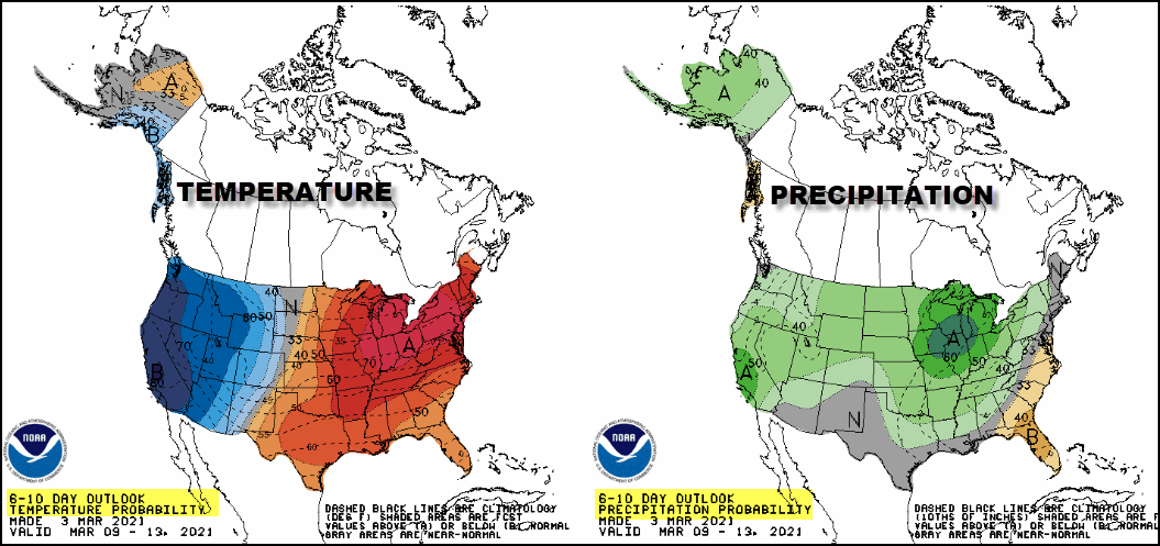
This is the 6-10 day long range outlook from the Climate Prediction Center. You don't need to be a rocket scientist to see the Midwest is expected to have well above normal temperatures and precipitation in the period March 9-13th
One only needs to take a quick look at the 500mb jet stream pattern for that time frame to see why. There are big height anomalies (negative west) and (positive east) representing a strong trough/ridge couplet over the nation.

In the west cold air resides within the trough and over the central and east, warm relatively moist air is being pumped northeast ahead of the cold pool. Where the two air masses clash, you have the fight zone (baroclinic boundary) where storms are born
These are the temperature departures the EURO sees with this set-up by Tuesday and Wednesday.

A closer perspective shows readings late next Tuesday 20-25 degrees above normal. Some places in Minnesota are up more than 32 degrees

The EURO suggests those departures produce highs that look like this next Tuesday.

With that type of warmth and such a stout SW flow for 72 hours, moisture is going to find its way deep into the upper Midwest. Available water vapor next Wednesday is shown exceeding 1 inch as far north as Minneapolis.

From my region north into Minnesota the water vapor levels are 2.5 to 4 times normal values. That indicates an unusually moisture rich system for so early in March.

That in turn fuels a strong storm on the nose of the powerful jet mid-week.

Here's the same surface reflection Wednesday evening showing precipitation wrapping into the center on brisk SW winds.

My area will be in the warm sector meaning rain will be the precipitation of choice. There's enough moisture and warmth to fuel instability that could pop Thunderstorms Wednesday. It's not overwhelming but the EURO does generate CAPE (convective available energy) which suggest the thunderstorm potential. This is the first time since last fall I have noted CAPE in the Midwest which is a good sign spring is waking up.

The product below depicts areas of lightning density and flash rates. This run indicates plenty of it ahead of the cold front as it advances through Iowa.

The EURO indicates rain totals that could exceed 1 inch, perhaps nearing 2 inches in some parts of my area.

Needless to say there are lots of details that need to be fine tuned at this distance, however confidence is medium to high that unseasonably mild air and moisture levels will lead to the warmest temperatures in nearly five months next week. Most areas should enjoy at least a couple days in the 60s, maybe three in a few spots south and east. It also appears that some areas could witness the first thunderstorms of spring next Wednesday. That increases the chances of locally heavy rain where where any storms do develop. Here's the EURO meteogram showing temperatures the next 10 days in Cedar Rapids. A far cry from where we were just a couple weeks ago when highs were below zero!

Short term, Thursday through Saturday look seasonal and dry. Existing snow cover will keep highs in the 40s near and north of I-80. Where the ground is exposed south of I-80 readings will be closer to 50. Then the warm-up really kicks in Sunday and readings approach 60 Monday though Wednesday. I propose a toast to that! Roll weather...TS
ONLY 37 COPIES LEFT:

I will take this opportunity to mention that I only have 37 copies left of my book on the most expensive thunderstorm in United States history (13 billion dollars in estimated damage). This will be the final printing. If you are interested in having the most authoritative account of this extreme event I would suggest you act now. Don't miss this opportunity to own the weather story of a generation. You can order yours at derechobook.com
BOOK ENDORSEMENT.
*This book has been quite the talk with the Iowa State Library promoting it. I have never seen the State Library promote any books like this unless it was an award winner of particular interest to libraries. Hopefully your sales are through the roof!
Jolene Kronschnabel-Director of Hawkins Memorial Library, La Porte City, Iowa


