


FIRST STRONG STORMS OF THE YEAR...
- Mar 10, 2021
- 2 min read
AMENDMENT TO PREVIOUS POST
The tornado watch I was expecting has been issued for my far western counties until 8:00 PM. I have added the graphic outline of the counties involved below. The rest of the post remains the same.

The potential exists for a few strong to severe thunderstorms to develop over parts of Iowa and SE Minnesota late this afternoon and early Wednesday evening. The Storm Prediction Center has issued this mesoscale discussion.

This is the text body associated with the MD. A 60 percent chance of a weather watch was noted by SPC forecasters.

The slight risk area issued by SPC just catches my western counties.

Storms are initiating now in central Iowa where there has been strong heating and dew points have reached the mid 50s in spots. That's allowed far more CAPE to develop than was indicated yesterday. Some areas in WC Iowa are up near 2000 j/kg

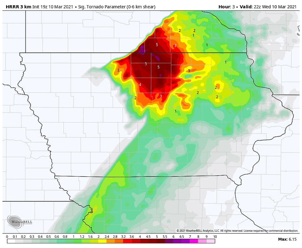
Notice the significant tornado parameters on the HRRR up around +5. That's a pretty hefty number for early March.
The tornado threat will be limited to a few hours and will quickly diminish towards sunset which keeps it focused more in NC IOWA and SE Minnesota. Eventually, storms should organize into a broken squall line that surges into eastern Iowa during the evening hours. By then the decreasing instability will diminish the strength of the storms. However, some strong winds and hail are possible in the stronger updrafts as the line heads east. After 9:00 pm the threat of severe weather is minimal but thunderstorms are still likely to advance across the rest of my area into Illinois ahead of the cold front.
We'll keep an eye on the trends and see if that watch gets issued out west. It's possible it could be a tornado watch which this early in the year could be a sign of what's to come this severe weather season. Roll weather...TS
ONLY 28 COPIES LEFT:

I will take this opportunity to mention that I only have 28 copies left of my book on the most expensive thunderstorm in United States history (11 billion dollars in estimated damage). This will be the final printing. If you are interested in having the most authoritative account of this extreme event I would suggest you act now. Don't miss this opportunity to own the weather story of a generation. You can order yours at derechobook.com
BOOK ENDORSEMENT.
*This book has been quite the talk with the Iowa State Library promoting it. I have never seen the State Library promote any books like this unless it was an award winner of particular interest to libraries. Hopefully your sales are through the roof!
Jolene Kronschnabel-Director of Hawkins Memorial Library, La Porte City, Iowa


Comments