


GOOD GOLLY MISS MOLLY, MORE SNOW...
- Apr 17, 2021
- 3 min read
Well first of all, let me start with a massive thank you to the nearly 1,000 people who welcomed my return to the Quad Cities in a week. I just can't get my mind around all the well wishes and positivity. The reason I put it out there was to warn you my posts might be a bit irregular and slightly abbreviated during extended moving process. Little did I know anyone would care. Anyway, you sure know how to make a man feel warm and fuzzy! By the way, I'll share one of the more direct and interesting messages which came from Ted Ketelsen who doesn't beat around the bush.

Funny stuff!. Thanks Ted, and to the hundreds more of you who made this an outstanding day when I really needed one. Respect and love to you all!
HAVE YOU SEEN SPRING?
We sure haven't seen much of spring the past week. The average temperature departures over the past 7 days look like this. A solid 5-7 degrees below normal per day.

I'm bummed to say that after a cool but relatively pleasant weekend, we are going back into the tank next week. These are the 7 day temperature departures for the period April 19th-26th. That stretch looks even colder than what we just went through.

Models continue to point towards Tuesday and Wednesday of next week as being extremely fresh with highs that might struggle to get above 40 in spots. The EURO shows this for temperatures Tuesday afternoon. Come on...

The big question on my mind is will it snow? For the past couple of weeks I've been touting the fact temperatures aloft were going to be cold enough at times to support snow in the central Midwest if we got the right set-up. From two weeks out you never know how forcing and boundaries will lay out so all I could do at the time was throw out the possibility in a process called pattern recognition. In other words, I can see the big picture but not the details or timing of the mesoscale details in the modeling ahead.
Well, today the picture is becoming clearer and it sure looks like much of the Midwest has not seen its last snowflakes and in some areas it could be more than that. What appears to be shaping up is centered around a strong late season cold front that sinks through the area Monday and then briefly stalls in Missouri. While some light precipitation is possible with the frontal passage Monday, that should be light rain, maybe a mix far north. The next wave is the one that works on the freshly delivered cold air and attempts to whip up some snow Monday night and Tuesday. The scenario is shown below on the EURO.

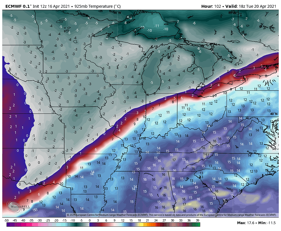
If that precipitation shield (shown in green) develops as shown, it is projected to fall into 850 temps of 6 to 9 below at the 5000 foot level. That's insanely cold for April 20th and will get snow all the way to the ground. A common concern this late in the season is that boundary layer temperatures are warm enough to melt the flakes just before arriving at ground level. It does not appear to be the case in this situation.

Even at 925mb, a half mile above ground readings are still 2 to 4 below zero. That has snow written all over it.
Assuming it happens, (not a sure thing yet) it would be a wet snow and the ground is warm so if there are accumulations, they should mainly be on grassy and elevated surfaces. Lots of compression too which potentially could make a 4" snow look more like a 2 incher.
Now onto the models and what they are showing for snow accumulations. Keep in mind, late season snow events are very fickle and challenging to predict. Small changes can make big differences. What you are seeing here are not forecasts, just raw model output, the stuff of which forecasts will be made closer to the event. Right now this is strictly guidance designed to point out trends. The more consistency we see, the higher the confidence. I'm using ensembles for the EURO and GFS output. Here you go.
The EURO

The GFS which is further south. I would not bet on that.

The Canadian GEM

The 12K NAM. (The model only goes out for a part of the event implying more snow than what it's showing).

Until we are sure about the track and thermal profiles of the situation all we can do is watch, wait, and wonder. However, I think some part of the central Midwest is in line for some very late accumulating snow. This looks really interesting to me. Good golly miss Molly! Roll weather...TS


Comments