


IT WASN'T MEANT TO BE...
- Jul 8, 2022
- 4 min read
For a couple days now, it's looked like a significant rain event was set to impact at least the southern half of my area Thursday night and Friday. Confidence was growing that amounts of an inch or two were likely, it was just a matter of where? Going into Thursday, the NBM guidance (a national blend of multiple models), showed widespread rain.

Thursday morning the hydrology experts at the Weather Prediction Center put out this rainfall forecast for the same period as the NMB blend.

The EURO indicated excessive totals that would cause real problems.

The GFS while not as aggressive, was still plenty wet as well.

Then came the 12z runs Thursday morning and boom, the whole set-up blew up before my eyes. In spots the rain was gone entirely, and where it was still shown in the south, it was quite a bit lighter. In Dubuque amounts went from 1.78" to nothing. In Davenport totals dropped from 4.01" to 0.52". Outside of the southeast tip of Iowa, nobody was showing as much as an inch.

What the heck happened. Well, it's hard to say but clearly models were having some initialization problems with data. (bad data in, bad data out). Some of that was likely tied to convection that produced heavy rain and outflow over Missouri Wednesday night. That altered boundaries, instability, and even intensity. These are known issues to contend with when forecasting convection and it was always my contention from the get go that the area from I-80 south was most likely to see the more significant rain. However, I did not see or expect the radical shift coming that eliminated the heavy rain threat for essentially all of my area.
As a forecaster, try as you will, sometimes things are just not meant to be and you pick up on the trend, pack it in (hopefully before others), and move on. In other words, you get the train back on the track! Sometimes that's easier said than done, but now that the event is unfolding the latest guidance is consistent showing a swing and a miss, maybe a ground ball in the south. Here's what the GFS and EURO depict for rainfall through Friday. This is nothing more than guidance but synoptically it makes the most sense to me with time running out. I like the idea that the majority of my area sees little if any rain. The lone exception would be the area south of HWY 34 down around Keokuk and Macomb where some moderate rains are possible. Even that may end up lighter than what's depicted.
The GFS

The EURO

The majority of what rain falls comes late Thursday night and Friday morning, although some spotty showers could linger into the afternoon. Temperatures should make it into the low 80s despite some passing clouds. With all the residual moisture it looks to be another muggy day. Good corn growing weather.
THE WEEKEND...
Saturday and Sunday a weak high pressure builds into the Great Lakes suppressing the heat dome even further to the west. That gets us into northwest flow aloft that delivers a nice looking weekend. After a brutal week of humidity, notice in the animation below how dew points fall from the 70s into the upper 50s to low 60s. Far more comfortable.

For the most part, highs Saturday and Sunday should be in the range of 81-85 degrees, a smidgeon below normal. We'll take it, sight unseen. Skies are expected to turn mostly sunny both days!
Our next cool front arrives Monday and while a shower or storm is possible, the EURO shows the front coming faster which gets it through before peak heating. Not only does that limit rain chances, it keeps temperatures a bit cooler than anticipated 24 hours ago. The GFS is slower and that matters as it generates a very steamy day with highs in the upper 80s to low 90s. It's additional heating generates much more instability for the front to work on making thunderstorms likely, some potentially strong. That's a long way away but those are the options on the table now.
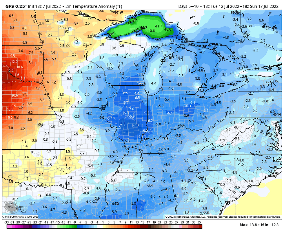
After that temperature trends become quite interesting. With the NW flow re-invigorated Tuesday-Saturday next week, the 5-10 day period should generally be dry and quite pleasant by mid-summer standards. The GFS shows these daily departures over that period. That could mean some upper 70s!
Unfortunately if the GFS is correct, the heat dome builds eastward once again allowing heat to return with a vengeance. At 500mb the upper high builds to 600 decameters, the hottest of the summer so far centered over St. Louis.

By July 21st, the GFS has temperatures 20-25 degrees above normal.

That results in highs that are above 100 in many parts of the Midwest.

We are well into the future here so there's plenty of time for the model to back away from this solution. However, it's my take that however this turns out, we are far from done with extreme heat this summer. I could certainly see that ridge expanding once again putting us right back into the hot box. Things could get really toasty in about a week!
Well, that's where things stand for now. It will be interesting to see how far north the big rains get Friday morning. Unless you are in far SE Iowa or WC Illinois, amounts look to be minimal, with some areas (especially north of I-80) seeing little if any rainfall . Roll weather...TS


Comments