


NOAA WINTER OUTLOOK WARMER...
- Oct 22, 2021
- 5 min read
FEELING THE LOVE. Over the past week thanks to your generous donations, we've been raising the funds necessary to cover the cost of this site. We are on our way and with your continued support we're going to make our goal. Still, we have a ways to go and I'm asking those of you that enjoy the insights and effort that goes into this site to consider a voluntary subscription. I'm asking $12.00 dollars for a year. That's $1 dollar a month or 3 cents a blog if you consider the fact there were 450 posts issued over the past year. The site requires a significant commitment of time and resources and every donation, whatever the size is deeply appreciated. I just need a little help to cover the expenses. Click on the link below if you can assist or or need additional information. I thank you for your support and consideration.

NOAA WINTER OUTLOOK UPDATE (MY THOUGHTS)
Some of you have heard and even messaged me about the revised winter outlook recently issued by NOAA. Based largely on what it believes will be a stronger than than originally anticipated La Nina, the outlook is warmer here in the Midwest.

Precipitation has increased some since the previous outlook and looks like this

The results were heavily based on the IRI seasonal forecasts with inputs from the NCEP-CFSv2, CanSIPsv2, and COLA-RSMAS-CCSM4, and GFDL-SPEAR models. This month’s forecasts also use the new climatological normal period 1991-2020.


As I mentioned, the biggest driver in this warmer outlook is the developing La Nina which is forecast to reach near moderate strength. Here are the model plumes, focus on the statistical average which near the heart of winter is around -0.6 below the neutral phase of 0.

Stronger La Nina's associated with cold water over the tropical Pacific tend to create a formidable zonal flow (west to east jet stream) which makes it harder for Arctic intrusions to enter deep into the United States. This favors cold in the northern tier and warmth over the southern half of the nation. In general, strong La Nina's tend to bring above normal temperatures to much of the nation.
For those of you who read my winter outlook several weeks ago, you recall I favored a winter that would be somewhat colder than average with near normal precipitation, perhaps a bit above. I also indicated that with the proper sea surface temperatures and teleconnections of the MJO and Arctic Oscillation, a relatively harsh winter was on the table. I looked for a faster start to winter as well with a colder and potentially snowier December than in recent years. Under the what could go wrong section, my "biggest concern" was that the La Nina turned out to be significantly stronger than forecast creating a temperature bust with much of the winter being influenced by modified Pacific air masses substantially warmer in nature.
I still haven't seen any strong reason to throw my outlook under the bus. Overall, the La Nina is doing about what was anticipated and until I see it go higher than anticipated I will hang tough. We've also got the sudden stratospheric warming going on which is unusual this early in the year and a wild card for cold.
Something else that's encouraging to me is the current seas surface temperatures in the Pacific. The top analog right now to where we are this year is 2008. Both were La Nina years and both show strong similarities, 2021 being a steroidal version of 2008. Also, the Atlantic this year is warm off the east coast which argues for a southeast ridge. Back in the Midwest that would put us within the mean trough and near the storm, a fun place to be. Ideally not overly cold but cold enough for snow systems.
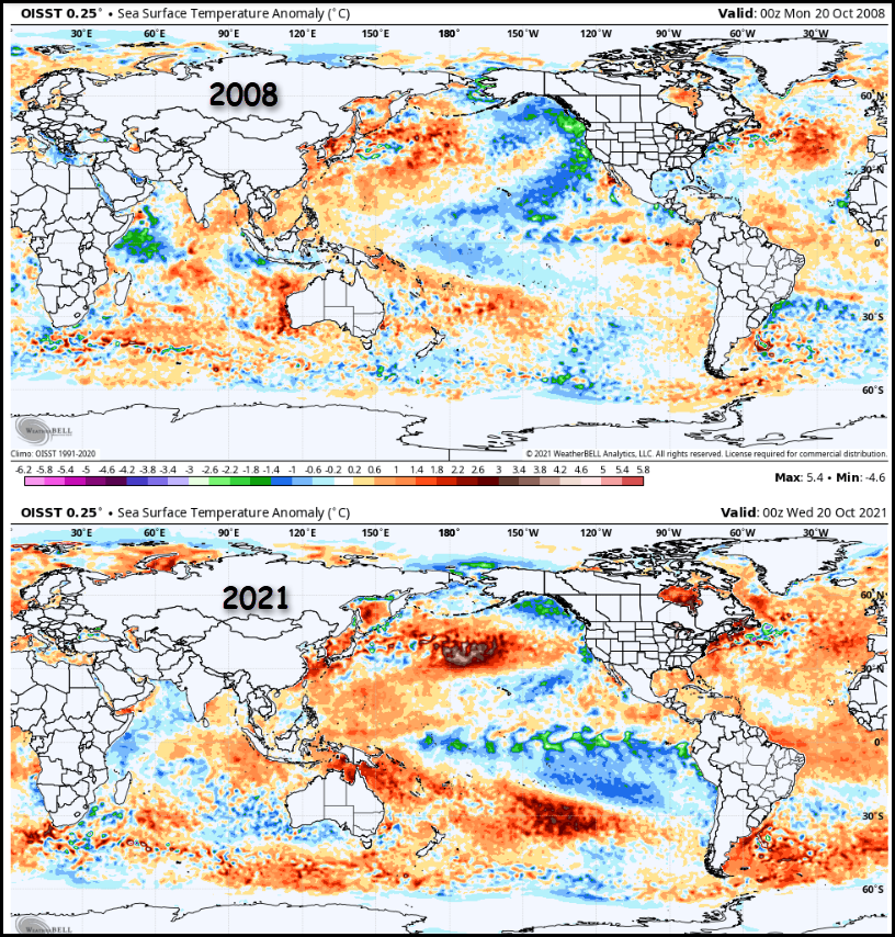
2007 also is in the mix and incidentally was a moderate El Nino winter. I looked up seasonal snowfall in the winters of 2007-2008 and 2008-2009 in Cedar Rapids. Those were big hitters with 56.6 and 45.5 inches respectively.

About three weeks ago 2013 was my best SST analog, you can see the early October comparison of 2013 to 2021.

The winter of 2013-14 was a tough one in my area, cold and snow ran the table all winter. What's interesting about 2013 is that the warm water in the NC Pacific in October moved into the Gulf of Alaska by early winter forcing a strong ridge to form off the west coast. That generated strong Arctic highs that repeatedly dumped cold air into the eastern 2/3rds of the nation. I will be watching to see if SSTs this year warm or continue to cool in the Gulf of Alaska. If by chance 2021 trends towards the lower panel below, let the party begin.

Just for kicks, the Cedar Rapids snowfall in the winter of 2013-14 came in at 42.9" All the years I mentioned above had big December's for snow. By the way, 2013-14 set the December-February record in the Quad Cities with 54 inches!

I'm not saying NOAA is wrong or that I'm right. I do still think there are some compelling reasons why this winter could be formidable. Nobody really knows, but just for the record I'm not throwing darts here or looking for attention. To me, the balance between a mild or cold winter is still slightly tilted cold.
One last bit of perspective, Steve Gottschalk my historian and weather folklore expert adds this:
I found 8 years with warm Octobers when La Nina's were in effect. 7 of those winters were normal to cold. I found 4 years with warm Octobers, cold May's and a La Nina like this year. All were cold.
Additionally, we have had 5 October days with thunder so far, this next system could bring more. When you have above normal thunderstorm days during the month there is a 67 percent chance of above normal snowfall during a La Nina.
Last but not least, I've seen ten woolly bears now and their markings point to near to below normal winter temperatures.
THE WEEKEND FORECAST
I'll make this part of the post relatively brief as I've already spent plenty of your time. Some of you out and about early already know that Jack Frost was in your hood. Skies cleared in my NW counties overnight and there readings dipped into the low to mid 30s under a frost advisory. Clouds in the rest of my area tempered readings significantly eliminating the frost threat.

Friday night frost and even freezing temperatures are possible but mainly across the north. Clouds will be the telling factor in how cold it gets. Some may linger in the south and that could keep readings from free-falling there. Needless to say we will know more regarding trends later Friday but be aware a frost advisory or freeze warning could be issued for many parts of the area.

The next order of business is the storm for the second half of the weekend. It is a well organized system with impressive dynamics and significant precipitation. Rain will arrive Saturday night in the far south and spread quickly into the rest of the region Sunday. With the storm track to the south, E/NE winds and precipitation will hold highs Sunday to the 40s in all but the far south. It will be one of the worst days in many months from the look of the charts tonight.
As for rain totals, it sure appears to be a soaker for most everyone with 1 to perhaps as much as 2 inches plus in the bucket before it ends late Sunday night or early Monday. Here's what models are suggesting.
The EURO

The GFS

The Weather Prediction Center

That will do it for this addition. Thanks for your time and if you appreciate the site please consider a donation by clicking the link below. The future of TSwails is in your kind and caring hands. Roll weather....TS


Comments