


SHOW ME THE STORMS, THE WAITING IS THE HARDEST PART...
- Dec 3, 2020
- 4 min read
FLATTENED CORN AND PARTS OF A GRAIN BIN AUGUST 2020 NEAR MARSHALLTOWN, IOWA

A SPECIAL THANK YOU
Before we get deep into the weather (or lack of it), I need to take care of some business. That involves thanking Melody Mercado of the Des Moines Register and Winona Whitaker of the Clinton Herald for features they produced in their papers regarding my new book, Derecho 911, Iowa's Inland Hurricane. Additional papers such as the Dubuque Telegraph Herald, The Galena Gazette, and The Quad City Times (to name a few) are also running articles slated to be published within the next week.

I am grateful to Melody, Winona, and the editors of their papers for seeing the importance of telling the story of this extraordinary Iowa storm. It will go down as the worst natural disaster in Iowa history and at least for now is the costliest thunderstorm in U.S. history with damage estimates at 7.5 billion dollars.
The book documents the damage, the stories, how this remarkable storm came to be, and why it will change the warning system going forward. It also explores the history of derechos in Iowa, their climatology, why they are the most difficult severe

storm to predict, and the Iowan who first coined the term.
Attention is also devoted to the severe impacts on Iowa's agriculture, power grid, and tree canopy. With 150 images, graphics, and diagrams Derecho 911 is the go-to resource for its detail to science, impacts, and survival stories of America's worst thunderstorm.
Order by December 15th and you can get your autographed copy by Christmas. It makes a thoughtful gift for that tough to buy for individual. Only 23 days til Christmas, time's a ticking so get your copy today exclusively at DERECHOBOOK.COM
THE WAITING IS THE HARDEST PART
December is a month I look forward to as back in Iowa it's one of the snowiest months of the year, or at least it was until the last 5 years. Those have been mild and snow free for the majority of my area. So I'm thinking its about time for the odds to even out as most spots from I-80 north have a 40-50 percent shot at a white Christmas in any given year.
At least for now, were not going to get any rain, let alone snow for what looks to be a prolonged period of time. This graphic here shows available water vapor which is necessary for any type of precipitation. Most of the country is covered by an extremely dry air mass with values in my area .10" or less. That's bone dry air.

Most of the eastern half of the nation is showing water vapor anomalies that are 15-35% of what's normal.

Here's the problem, the upper air flow is diving in from the north impeding any moisture from entering the pattern
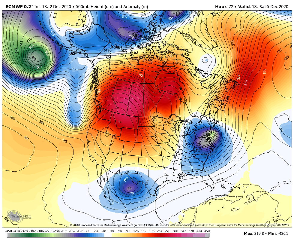
This is forecast to go on for what could be a couple more weeks. If the EURO is to be believed and I see no reason to fault it, there's no measurable precipitation in the Midwest the next 10 days (240 hours).

Just as pathetic, the EURO ensembles show little if anything the next 15 days, out to December 17th. I have doubts about that.

So for me, I'm playing the waiting game for storms which is always the hardest part. I'm not a patient man, especially when a set-up like this evolves in December during the prime of the snow season. These charts are painful for me to even look at.
As for temperatures, the next 15 days should be near to above normal until the end of the period when the day 10-15 period shows some significant cooling. Here's the 5 day breakdowns on the EURO at 850mb.
Day 0-5

Day 5-10

Day 10-15

Around day 15 the cooling indicated is a hopeful sign that a new pattern is emerging that can get some snow into the pattern by Christmas. I'm not holding my breath but it looks better for some storms and there is some cold air around. My next concern is that we get into a negative PNA (Pacific North America) which would deliver a trough to the west just before Christmas. Again, that's good for getting moisture back into the Midwest but the storm track can get pulled far enough NW to bring rain instead of snow. The position of that trough will be critical and needs to be watched. Anyway, I'm getting ahead of myself and at least for the next 10 days It's going to be a mighty quiet time for weather around the central U.S.
WHITE CHRISTMAS WATCH
With Christmas just over 3 weeks away I'm starting a feature called white Christmas Watch. I will try to put the ensembles of the EURO, GFS, and CANADIAN GEM up on a regular basis to give you an idea of what the models are showing. I do want to stress these are absolutely NOT forecasts and are not intended to be taken as such. Ensembles are an average of numerous solutions, some with more snow and often others with none at all. However, the average gives forecasters an idea of where trends are heading. When all three models are showing 6 or more inches in a given area that is a strong trend and one that probably has merit. 1-2" is low end and nothing to bank on. Just wanted you to see what I see behind the scenes and thought you might find it fun to watch as arm chair quarterbacks. There's a multitude of other factors that must be considered. Alright then, here you go with output that extends out to roughly Dec. 17-18th.
The EURO ensembles (average of 51 member solutions)

The GFS ensembles

The Canadian (GEM) ensembles

And with that I sign of. Here's hoping you have a fantastic day. Roll weather...TS


Comments