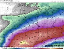
SNOWY, COLD START TO WEEK
- Oct 25, 2020
- 1 min read
Snow fell in parts of the Midwest Sunday and a few inches piled up in northwest Iowa, even covering the roads at times:

(Photo via Iowa DOT snow plow camera)
Some snow showers will linger into Monday morning across parts of Iowa and Illinois as a disturbance moves through:

Accumulation will be pretty minor, especially south of Highway 20:

Then even colder air settles in behind this front for Monday afternoon:

Temperatures will be close to records for Monday for the coldest high temperatures on October 26th, records will likely be set in areas where more snow fell. Same concept Monday night into Tuesday morning:

Tuesday remains cold but temperatures will gradually climb through the rest of the week. We go from having a big trough in the upper levels of the atmosphere (low pressure, generally colder weather):

To a big ridge (high pressure, warmer weather) by the end of the week:

Temperatures will get back into the 50s and even some 60s by the end of the week and early next week. Here's the temperature outlook from the Climate Prediction Center for November 2-8:

Maybe we will get a little fall, after all!
RK
PS -- don't forget to order your copy of Derecho 911. Terry Swails and Carolyn Wettstone have been working on telling a comprehensive story of the historic derecho of August 10th, 2020. It includes a history of derechos, the meteorology behind this intense storm, and real accounts of the storm from people who went through it. Take advantage of a discounted price by pre-ordering the book now! Click on the picture below to purchase:


Comments