SOUPY AND SOGGY IN SPOTS...
- Jun 29, 2021
- 2 min read
Well we're right back in the soup again thanks to a squeeze play at 500mb. Here you can see the SW flow of the jet stream aimed directly at the Midwest drawing deep tropical moisture. The end result has once again been very muggy conditions and scattered showers and storms with localized heavy rain.

Water vapor available for the production of precipitation is well above normal reaching levels up around 2 inches.

That's producing dew points Monday night that are in the range of the low to mid 70s and that is why it feels so damp and sultry.

The abundance of moisture means the fuel is there for heavy rains in just about any part of my area into Tuesday night. The caveat is the location of forcing that can trigger showers and storms. What there is, is rather strung out with a slightly greater focus centered on the southeast. The late night and afternoon hours are preferred for the best chances of organized rain in a situation like this. With somewhat better odds in the southeast (and rains hitting that area harder in past days), the NWS has issued a flash flood watch for the SE half.

The Weather Prediction Center does have a slight risk outlook for excessive rains over the SE Tuesday.

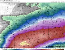
These are the rainfall totals over the past 7 days through 7am Monday. Some of my northern counties are still on the outside looking in while parts of the south have really been soaked.

After Tuesday night a front will slowly sink southward pushing rain chances out of the north by Wednesday. The south however, remains in play and some additional showers and storms are expected with pockets of heavy rain. Over the next 48 hours, these are what the models are showing for potential rain totals. You can see the variance in amounts and the hit and miss nature of the rain with an emphasis on the southeast. I wouldn't put much stock in any of these solutions with the random nature of storm development. It will rain where it wants no matter what the model or the forecaster implies.
The EURO

The GFS

The 3k NAM

The 12K NAM

The HRRR

From Thursday on (and right on into the 4th of July), the forecast looks essentially rain free and comfortable by early July standards. Highs should generally be in the upper 70s to low 80s, perhaps mid 80s late in the weekend. Humidity levels will drop too and Friday and Saturday will be sweet. Sunday and Monday that changes as southerly winds return muggy conditions for the second half of the holiday period.
That's a wrap for now. Have an excellent day and roll weather...TS


Comments