


WHICH DOOR DO I PICK...
- Nov 30, 2023
- 5 min read
The wicked winds of the north were "not" blowing Wednesday, and what a difference that made in our temperatures. Highs area wide reached 40-45, a nice recovery from the 20s of Monday and Tuesday. With readings again in the 40s Thursday, we'll end the month of November with above normal temperatures, concluding a month in Davenport that saw highs as warm as 71 and as cold as 4.

Wednesday's warmth took care of much of the snow that remained from our weekend dumping of 2-4 inches. Early in the day, enough of that remained for it to show up nicely on the GOES hi-res visible satellite. When the image was taken around 9:00am, skies were fair, meaning the white areas represented the snow covered fields and yards of the region. Take a look. You can even see the river valleys etched in the snow field.

The quiet weather of Wednesday will be with us again Thursday, but the pattern is in a state of flux and changes and challenges are in the forecast to start the weekend. Here's the large trough over the west that brings the unsettled period.

Unfortunately for me, there are a number of ways the next few days could turn out, with multiple disturbances in the flow. I've got several doors that I can pick from, and that being the case, I'm going to have to make tough choices and take things a day at a time until the overall picture becomes a little clearer.
SYSTEM NUMBER ONE
The first hurdle is a southern stream impulse, which darts NE through Missouri early Friday, passing close to St. Louis. Precipitation will blossom and work into my southern counties late Thursday night. The CAMS (hi-res convective allowing models) are furthest north on the track, eventually forcing the precipitation shield all the way to HWY 20. The GFS is a little further south, but not by much. The track of the EURO is furthest south, which confines precipitation to the south of HWY 30. So, the first order of business is how far north does measurable rain (and snow) get?
With cold air somewhat limited, I'm thinking the EURO's less amplified and more southerly track might be the way to go, especially with the system opening up and weakening as it lifts NE. I'm leaning that way, but there's no way to know for sure at this point.
At any rate, rain develops over the south Thursday night and then reaches into at least the southern half of the region Friday morning. As it gets further north, it is expected to mix with freezing rain or snow and eventually change to snow with thickness levels falling, especially north of I-80 and on towards HWY 30 (perhaps even further north than that if the CAM's are correct). That brings to mind potential accumulations, another challenge with marginal surface temperatures. If snow does accumulate, it may be more on grassy and elevated surfaces as opposed to roads. Snowfall rates will determine the outcome. The NWS in the Quad Cities had issued a Winter Weather Advisory for the following counties in EC Iowa for a period of icing and eventually snow that could accumulate 2 inches Friday morning.

The CAM's are a little spooky, with some totals up to 6 inches, but I think vertical velocities are inflated due to their stronger solutions. I prefer the lighter totals of the deterministic EURO and GFS. Hopefully we can pin this issue down later Thursday with newer data. That said, here's what models are suggesting for accumulations. Remember, the 3K and 12K NAM are the worst case scenarios and are far less likely. My central counties near and north of I-80 seem to be favored most for any accumulating snow early Friday.
The EURO

The GFS It has trended warmer at 850 which keeps most of its snow north of HWY 30.

The 3k NAM

The 12K NAM

THE GEM

These are the total precipitation amounts shown on the EURO and GFS through Friday afternoon. You can see the GFS is further north with the northern extent of its precipitation band.
The EURO
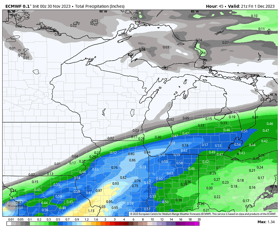
The GFS

THE NEXT HURDLE
The next hurdle is two more disturbances that are shown right on the heels of the first. The general idea is that after a break in Friday's rain and snow, a new band of mainly snow moves rapidly NE Friday night. The best lift appears to be NW of the Quad Cities, which means this event has its best chance of laying down some light snow over the NW half of the region before it departs by Saturday morning. Amounts of an inch (maybe 2) are a consideration.
ONE FOR THE ROAD
Another wave of energy follows a similar track late Saturday and sends what could be a third wave of precipitation Saturday night, ending early Sunday. While precipitation is shown in all areas, my SE counties may be warm enough to see a mix of rain or snow (perhaps just rain in the far SE). That would preclude accumulations there, but again some 1 inch plus totals would again be possible over the NW half of my area (mainly NW of the Quad Cities).
While it's very early, a clipper is shown Tuesday that could kick up some additional light snow, mainly over the NE half of the region. That's all I will say about that for now.
All things considered, this is not what I would classify as a high confidence forecast, especially regarding where snow falls and how much. This is one of those situations where it will be a tough forecast right up to each individual event. All we can do is take 'em one day at a time. As it stands now, I don't look for substantial accumulations or significant travel issues with any of these events.
If you are not into all the mention of snow (be it generally light), your time is coming. I see a big warm-up in about a week that could send temperatures well above normal and into the 50s. Ugh! These are the temperature departures on the GFS, Friday December 8th.

With that, I will sign off wishing you all a productive and pleasant day. Roll weather...TS
ENJOY THE HOLIDAYS AT THE LITTLE WHITE CHURCH OF GALENA, A HEAVENLY AIRBNB...

A HEAVENLY RETREAT
The Tree is up, and the fireplace is toasty. Get family and friends together and enjoy an affordable stay at a 5-star Galena accommodation, one of the premier travel destinations in the Midwest...now an Airbnb Superhost. Close to skiing, wineries, great food, and all the beauty and fun Galena has to offer. Book directly through us, and we can reduce the cost by eliminating the fees and taxes charged by Airbnb!
5 beds, 3 full bathrooms, and a stunning view. All of our reviews have been perfect 5-star scores. Recent guests' say:
Jill The Little White Church is beautiful. The decorations are perfect, and it was redone with impeccable taste. Carolyn was a great host.
Phillip
Amazing and thoughtful renovation. Stayed in a piece of history. Great location and modern amenities. Would stay again! The place is spotless with a spacious private backyard, great kitchen, clean bathrooms and baths...we would highly recommend this place!
Brent
Such a gem. Relaxing in the rural countryside in a historic church that was beautifully decorated and recently renovated was exactly what we experienced. Everyone loved the stay. We will definitely be back!!!
Call or text Carolyn with questions and the best deals at 563-676-3320 or fire off an email to carolynswettstone@yahoo.com Hope to see you soon. T.Swails


Comments