FRESH WATER FURY...
Over the weekend a significant storm blew up over Lake Michigan known as a fresh water fury. These tempests have a long history of disrupting shipping on the Great Lakes during the fall when they bring the dynamics of cold upper air troughs into the summer warmed waters of the lakes . When conditions are favorable, explosive development takes place and heavy wind swept rain (and snow) is the end result. That’s exactly what happened in November of 1913, when an Arctic front sw

A CASE OF FALSE FALL...
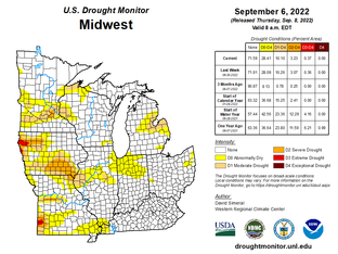
A big low pressure system has brought a big taste of fall weather to the area. It also brought some beneficial rain to the region. Here's a look at the rainfall totals Saturday through Sunday morning: Of course this rain once again missed the spots that needed the rain the most. Just to recap, here's where the drought conditions stand in Iowa: There will be a chance for some showers early Monday especially in far eastern Iowa and Illinois: Temperatures will be held down below

FALLING DOWN...
Our temperatures were falling and rain was falling down Saturday. You can see the impact of this weekend's cold front, sending temperatures down across much of the country: The slow moving storm will continue to produce rain into early Sunday morning in southeast Iowa into Illinois: Sunday will be cloudy and cool: Additional showers will rotate in late Sunday as the upper level low continues to swirl in the Great Lakes region: Rain will continue into Monday in far eastern Iow

A SUPER SOAKER...
While the majority of my area has managed to escape drought conditions this summer, that can't be said for my far southern counties. Most of the rains the past two months have missed that region allowing moderate to severe drought to develop and expand. My southern counties are on the eastern fringe of a large region of drought centered on the Plains that's slowly creeping into the SW half of Iowa. Notice much of the Midwest's dryness is focused on the NW half of Iowa and ce

A HAND-OFF IS COMING...
We've still got a couple more days of solid September weather to enjoy but a hand-off is coming. Not only will we see a turn to below normal temperatures, wet weather is likely to accompany the change. As they say, all good things must come to an end. The catalyst in this meteorological swing is a cut-off low that digs into the upper Midwest over the weekend. Models initially carve out an elongated trough (that aided with the injection of additional short wave energy), event