SUICIDE RIDGE AND THE LAND OF THE DRY...

I'm one of those odd dudes that looks for storms. Strange as it is, the first thing I do when I get up and the last thing I do before going to bed is check anything that might stir up weather trouble. From the first hint of a storm until its dying days I'm intimately involved in all that it does.
Today I was looking at the charts and it struck me, we're entering into a lousy weather pattern and I'm going to need a new hobby the next couple of weeks. I say that because I won't be getting friendly with any storms in the near future. A stout ridge is expected to set up over the northern Rockies and that will be the kiss of death for active weather here in the central Midwest. It's what I call the suicide ridge. Here it is on the 500mb jet stream chart February 17th.

The northwest flow coming off the ridge will keep moisture out of the pattern across the Midwest and the storms that form will be on the east side of the two troughs. That means the west and east coasts will be where the weather action is.
A really great way to illustrate my point is to show you the 16 day precipitation forecast off the GFS.

The entire west coast and much of south and east will be wet and wild. The center of the country near and east of the ridge just the opposite. Here's a tighter view of the 16 day precip. over the middle of the nation. A lot of what you see from Illinois east has already fallen. Some parts of Iowa and Missouri southwest into the Plains have 1/10th of an inch or less over the 16 day period.

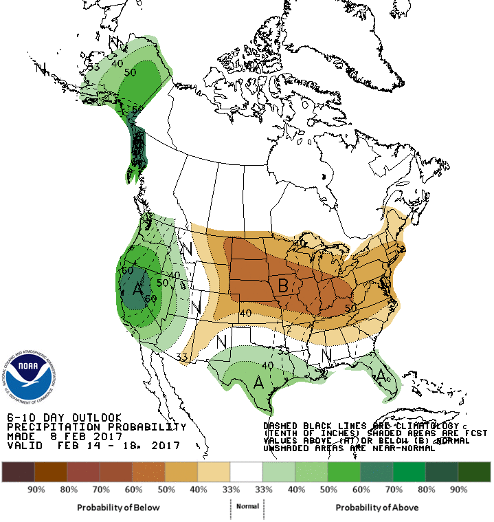
The 6-10 day precipitation forecast from the Climate Prediction Center is very much in sync with what the models are showing.

Not only does it look dry, the ridge looks to promote mild conditions around the Midwest. Here's the 6-10 day temperature outlook.

If all goes according to plan, the suicide ridge means the best of both worlds here in the heartland, mild and dry! We'll get our next warm-up cooking in less than 24 hours. Check out what the EURO is calling for highs Friday afternoon.

Now that's the way to start the weekend. Until next time roll weather...TS


