


A LITTLE BIT ABOUT A LOT OF THINGS...
- Aug 31, 2017
- 2 min read
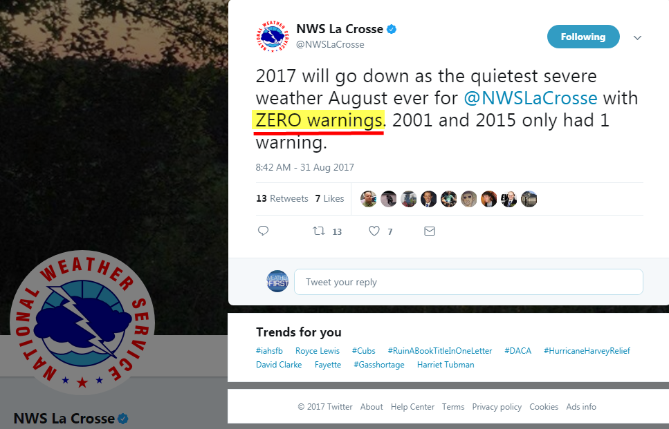
As I was digging through data today I came across an interesting tweet from the NWS in La Crosse, Wisconsin. As you can read they did not issue a single severe weather warning during August. That's the first time that has ever happened and so this goes down as the quietest severe weather August on record for NE Iowa, SE. Minnesota, and SW Wisconsin.
It isn't surprising when you consider the lack of warmth and moisture over the region during August. Much of the Midwest ended up running 2-5 degrees below normal on temperatures during the month.

Precipitation has also been light, especially over much of my area where monthly rainfall has been less than 1/2" between Iowa City and the Quad Cities. Here's the August total rainfall centered on Iowa.

Below in the monthly anomalies you can see August rainfall running 2-4" below normal over much of eastern Iowa and northern Illinois.

The ongoing lack of rain continues to fuel drought over many parts of Iowa and WC Illinois. The latest drought monitor issued Thursday shows the worst conditions in southern Iowa.

The long range forecast is far from promising with the GFS showing this for rainfall the next 16 days. Nothing in parts of Iowa and SW Wisconsin. On average most of the region should see at least 2.00" over that 16 day period.

Here's a larger perspective of the 16 day GFS rain forecast. Pretty darn dry across the Midwest.

The 8-14 day rainfall outlook from the Climate Prediction Center also shows the dry pattern.

The bottom line is that the holiday weekend ahead should be a dry one. After a pleasantly cool start Friday, temperatures will climb and some spots could see their warmest readings in a month. For my local area that means highs Sunday and Labor Day in the mid to upper 80s.
Last but not least, another concern is growing in the Atlantic. Hurricane Irma (at the time of this post a major category 3) is heading west.

The storm is moving into a favorable environment to strengthen even more. The EURO which nailed the track of Harvey shows the storm with a good chance to strike some part of the U.S. in about 9-10 days. Below on the left you can see its EPS ensemble members showing various tracks that range from the western Gulf to just off the east coast of the country. The mean of all the solutions right now has a landfall near the Carolinas.

The majority of the EPS members have the storms winds reaching at least 140 mph. Several members are showing winds of 175. That would make it a powerful category 5. It's far too early to know how Irma evolves but there are some very ominous signs. Here's hoping this one stays out to sea. Until next time roll weather...TS


Comments