


THE WINDS OF CHANGE ARE STIRRING...
- Apr 8, 2019
- 2 min read
After a long, hard winter there's nothing like the first stretch of warm spring weather. Those days when you can wear shorts, t/shirts, and see the grass turn green before your eyes. Here in Cedar Rapids we strung together 3 consecutive days with 70 degree highs. The last time we did that was September 23-25th of 2018!

Monday was the best of the bunch with highs in the range of 75 to 80 common across Iowa. Des Moines and Waterloo both peaking at 80 for the first time this year.

While it will be about 15 degrees cooler Tuesday, it still looks like a decent day with highs of 60-65 under partly sunny skies.
After that the winds of change start blowing as the Midwest comes under the influence of a powerful spring storm that promises to bring a wide variety of weather with significant impacts. The way it's looking now the surface low will deepen to 975 to 980 mb) Wednesday over SE Nebraska. The NWS in South Dakota calling the storm "potentially historic" in that state. It looks very similar to the bomb in mid-March that produced the record flooding in western Iowa and eastern Nebraska along the Missouri. This time there's no snow on the ground so flooding of that magnitude is unlikely. However, heavy precipitation of 2-4" will be widespread over Nebraska, eastern South Dakota, southern Minnesota, and NW Iowa. With saturated grounds flooding of some magnitude is likely to resume following the storm.

One aspect of the system that will make it severe in the cold sector will be heavy wet snow and powerful winds in excess of 50 mph. White out conditions are expected in some areas with snowfall rates of 1-2" per hour. Look at what the models are showing for snowfall.
The EURO.

The GFS

The Canadian GEM

With the storm tracking so far NW, the heaviest precipitation should bypass all but the far northern parts of my area (roughly north of HWY 20 north).

Here's the latest rainfall forecasts.
The EURO.

The GFS
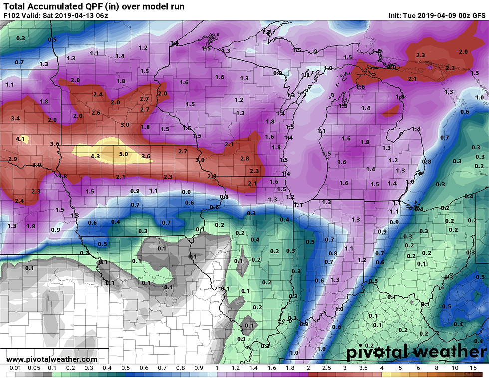
The Canadian GEM

The other big story with this storm will be the winds. They are going to howl 30-45 mph in many spots Wednesday and Thursday. The easterly component will dramatically cool temperatures Wednesday when highs in my area will remain in the 30s north and 40s south. Thursday, depending on how far north the warm front can return, highs could range from the upper 30s north to low 70s south. A very tight thermal boundary that's extremely difficult to forecast.
Thursday could also be a day when some strong storms may pop up late over far SE Iowa and WC Illinois. The timing of the cold front and dry punch will be key to the instability and where any storms can fire. At this point the area SE of the Quad Cities in Illinois is most favored. Something to keep and eye on.
The bottom line is we have one more day of mild tranquil conditions before the weather hits the fan. Until next time, roll weather...TS


Comments