


WICKED WIND OF THE WEST...
- Nov 27, 2019
- 5 min read
PLEASE CONSIDER THE VALUE...TSwails.com has been far ahead of the competition in catching and forecasting the trends of our extreme weather the past few weeks. It takes a great deal of commitment, passion, and knowledge to do that. Now that I'm no longer in television, this is my job and that's the reason I'm asking for a voluntary subscription fee of $12 dollars a year, one dollar a month to keep TSwails going. Together we can create one of the best, most unique, and reliable weather sites in the Midwest. Your contribution of 3 cents a day, allows me to stay free of the corporate world and pour my energy into doing what I do best, forecasting the weather! We hope you see the value and hard work that goes into the site everyday. You support in any way is sincerely appreciated. Thanks and roll weather. To donate click on the secure green box below.

That powerful late fall storm is now well into Wisconsin. Rain and snow is now over for my area and is pretty much finished in Minnesota and the SW half of Wisconsin. 6-12" fell in a band from NW Iowa through NW Wisconsin.Here are some snow reports.
Iowa:

Regional snow reports:

As of late morning many roads are reported to be snow covered where the heavier snows fell and travel is slow. However major roads and interstates are improving quickly and by late day conditions will be much better on any treated or plowed roads.
Here are late morning road conditions.
Iowa

Minnesota
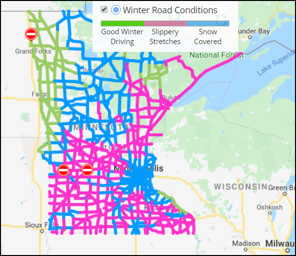
Wisconsin

With precipitation ending the big issue the rest of the day will be the wicked winds of the west which could gust over 50 mph. That will cause issues for high profile vehicles such as semi's and RV's. Tonight the winds ease and weather conditions will be much better right on through Thanksgiving Day. The next system impacts the Midwest late Friday into Sunday. For my area occasional rain will be the issue until colder air turns the rain to some snow showers Sunday. Any accumulations in my area appear light, an inch, probably less. The weekend snow forecast from the GFS.

Got to do some holiday traveling myself so for now I'm signing off. Will be back with you later when I arrive at my turkey eating destination. Safe traveling to all and enjoy the holiday! Roll weather...TS
PEOPLE! Christmas is only a month away. Are you looking for something special for that hard to buy for person? Maybe you just want to treat yourself for being on the nice list! Well, here's an idea that can "give" any weather enthusiast a lifetime of pleasure. It's called WEATHER SCHOOL. What a person experiences here will open up the world of forecasting for years of enjoyment to come. Consider giving the gift of weather. Better hurry, only 18 seats left. You can get all the details below.

TSwails.com is offering a very special and unique opportunity to learn first-hand the ins and outs of weather forecasting with one of the best meteorologists in the Midwest along with his team of expert meteorologists.
That’s right… You want to forecast right along with Terry Swails, well now you can. He’s teaching weather with TSwails newest program called WEATHER SCHOOL. The opening bell rings this January and you can be a member of the very first graduating class. The one-day forecasting seminar for weather enthusiasts will be held at his home in January. It’s not your typical run-of-the-mill school. There will be no tests, but Terry, Rebecca, and Nick will cram your head with so much knowledge, it’ll be spinning like a tornado before the day is over
You want to know the essential online sites to use for models, radar, and the basic weather tools? DONE! You want to understand the structure of models and the role they play? DONE! You want to be able to construct forecasts from the ground up? DONE!
WEATHER SCHOOL will be presented in a seminar-type format where you'll have the ability to ask questions and dig deep. You’ll get the scoop on data acquisition, model analysis, severe weather, and actual forecasting from the big dog himself, T. Swails. With 43 years of experience and an uncanny ability to break the science down, you’ll open the door to forecasting like never before.
Along with the head master T. Swails himself, meteorologists Rebecca Kopelman and Nick Stewart of KGAN TV will be there to lend their knowledge and experience to the discussion. It will be fun, informative, and factual! This is the day for you to see, feel, and experience what it’s like to be in the hot seat of a meteorologist.
The seminar will be held January 25th and will last from noon until 5:00pm. We have limited seating and the cost is $99 dollars per person. A catered lunch will be provided. Again..not a lot of seats so reservations with a pre-payment are required. Sorry, no refunds. If there’s enough interest, a second session will be added in early February. To register or get additional information send an email to carolynswettstone@yahoo.com
GIVE THE GIFT OF WEATHER. This might be the perfect gift for that hard to buy for person this Christmas. Along with a WEATHER SCHOOL admittance voucher, TSwails will send a special holiday greeting to your weather enthusiast if you give the gift of weather with the TSwails touch!
WEATHER SCHOOL AGENDA:
WELCOME AND INTRODUCTION
Purpose: To help weather enthusiasts understand the basics of forecasting and apply the knowledge and techniques learned to construct personal forecasts.
Session 1: DATA ACQUISITION
The essential on-line sites for models, observations, satellite and radar images, and general weather data.
Session 2: ANALYSIS:
Determining your objective goals. Short term, intermediate, or long-term. Understanding the process of analysis and its relationship to forecasting.
Model options and choices. What to use and when!
The GFS, EURO, NAM 3k, NAM 12K, Canadian, HRRR, MJO, ensembles, teleconnections, etc.
Locating, learning, and knowing what’s essential to make a reliable forecast.
The art and science of model interpretation: Using and understanding model output. Its called guidance for a reason!
Learn how to analyze key parameters such as:
Surface and upper air data
Vorticity and energy
Precipitation output
Wind and pressure
Session 3: MAKING A FORECAST FROM MODEL GUIDANCE
A simulation of the basic process using model output.
BREAK: A 25-30 minute recess to enjoy a catered lunch…
Session 4: SEVERE WEATHER:
Thunderstorms, tornadoes, derechoes, and squall lines.
Soundings. What are they and why should I care?
Instability (CAPE) vs (CIN) Critical interaction involving moisture, heating, and forcing.
Uncovering the ingredients of a severe weather set-up.
TVS signatures. What to look for on radar.
Role of SPC vs NWS, and your local TV station regarding the warning process.
Simulated model driven forecast of a severe weather event/tornado outbreak
Session 5: WINTER STORMS:
The key ingredients required for significant winter storm:
How to forecast the rain snow line.
How to forecast snow totals from QPF
Determining totals from snow ratios.
What to look for at the surface and at upper levels (500 and 850mb)
Model bias and determining the storm track
Simulated model driven forecast of a significant Midwest winter storm
QUESTION AND ANSWER SESSION
An open period for attendees to ask questions regarding relevant topics or issues discussed during the day.
CONCLUSION:
Some final words of inspiration from the events headliners
Once again, to reserve a spot or ask questions send an email to carolynswettstone@yahoo.com See you when the bell rings! Roll weather...T. Swails


Comments